![](/images/other/stat-length.png)
![Tour Mountainbike Louvemont - LAC du DER ... le canal des Fabriques. - Photo](https://media.geolcdn.com/t/1900/400/b6538103-d610-48f2-ba11-16ea1b3e6267.jpg&format=pjpeg&maxdim=2)
LAC du DER ... le canal des Fabriques.
GerardBouche
Benutzer
![Länge](/images/other/stat-length.png)
Länge
9,7 km
![Maximale Höhe](https://static1.geolcdn.com/siteimages/upload/files/1508320355ic_sort_altitude_max_24dp.png)
Maximale Höhe
191 m
![Positive Höhendifferenz](https://static1.geolcdn.com/siteimages/upload/files/1508320355ic_sort_den_pos_24dp.png)
Positive Höhendifferenz
88 m
![Km-Effort](/images/other/stat-length.png)
Km-Effort
10,9 km
![Min. Höhe](https://static1.geolcdn.com/siteimages/upload/files/1508320355ic_sort_altitude_min_24dp.png)
Min. Höhe
139 m
![Negative Höhendifferenz](https://static1.geolcdn.com/siteimages/upload/files/1508320355ic_sort_den_neg_24dp.png)
Negative Höhendifferenz
89 m
![Boucle](https://static1.geolcdn.com/siteimages/upload/files/16400158638029165_repeat_loop_refresh_sync_direction_icon.png)
Boucle
Ja
Erstellungsdatum :
2020-09-14 07:52:51.905
Letzte Änderung :
2020-09-14 09:25:03.387
![Mountainbike](https://static1.geolcdn.com/sitytour/trail-icons/202.png)
1h27
Schwierigkeit : Sehr leicht
![Scannen Sie diesen QR-Code, um die Tour in der SityTrail-Anwendung zu öffnen](https://capi.geolives.com/qq0zvz2zws4bq2lad0pu/sitytour/trails/2550346/qr.png?size=200)
Kostenlosegpshiking-Anwendung
Über SityTrail
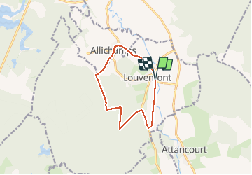
Tour Mountainbike von 9,7 km verfügbar auf Großer Osten, Haute-Marne, Louvemont. Diese Tour wird von GerardBouche vorgeschlagen.
Beschreibung
Par le canal de St.Dizier, le Château du Petit Bois, le Château de la Sablière et de très beaux petits sentiers dans la foret domaniale du DER.
Ort
Land:
France
Region :
Großer Osten
Abteilung/Provinz :
Haute-Marne
Kommune :
Louvemont
Standort:
Unknown
Gehen Sie:(Dec)
Gehen Sie:(UTM)
641269 ; 5379337 (31U) N.
Kommentare
Touren in der Umgebung
![Tour Mountainbike Éclaron-Braucourt-Sainte-Livière - Lac du DER - CHANTECOQ ... par St-Marie- Nuisement. - Photo](https://media.geolcdn.com/t/375/260/0f27a926-3a1d-4ecb-8e04-b7fa88246190.jpg&format=jpg&maxdim=2)
![Mountainbike Mountainbike](https://static1.geolcdn.com/sitytour/trail-icons/202.png)
Lac du DER - CHANTECOQ ... par St-Marie- Nuisement.
Mountainbike
Sehr leicht
Éclaron-Braucourt-Sainte-Livière,
Großer Osten,
Haute-Marne,
France
![](/images/other/stat-length.png)
37 km | 40 km-effort
3h 13min
![](https://static1.geolcdn.com/siteimages/upload/files/16400158638029165_repeat_loop_refresh_sync_direction_icon.png)
Ja
![Tour Rennrad Louvemont - 24 08 2020 WASSY - Photo](https://media.geolcdn.com/t/375/260/792bb28f-ea85-4049-9dd3-646f5ebb5ba7.jpg&format=jpg&maxdim=2)
![Rennrad Rennrad](https://static1.geolcdn.com/sitytour/trail-icons/201.png)
24 08 2020 WASSY
Rennrad
Einfach
Louvemont,
Großer Osten,
Haute-Marne,
France
![](/images/other/stat-length.png)
37 km | 40 km-effort
2h 27min
![](https://static1.geolcdn.com/siteimages/upload/files/16400158638029165_repeat_loop_refresh_sync_direction_icon.png)
Nein
![Tour Mountainbike Louvemont - Espace VTT FFC Lac du Der en Champagne - Circuit n°06 - Le canal des Fabriques - Photo](https://media.geolcdn.com/t/375/260/ext.jpg?maxdim=2&url=https%3A%2F%2Fservices.sitytrail.com%2FGeolivesWS%2FDownloadMedia.ashx%3FTrailID%3D102267%26Media%3D2728_1.jpg)
![Mountainbike Mountainbike](https://static1.geolcdn.com/sitytour/trail-icons/202.png)
Espace VTT FFC Lac du Der en Champagne - Circuit n°06 - Le canal des Fabriques
Mountainbike
Medium
Louvemont,
Großer Osten,
Haute-Marne,
France
![](/images/other/stat-length.png)
8,8 km | 9,9 km-effort
40min
![](https://static1.geolcdn.com/siteimages/upload/files/16400158638029165_repeat_loop_refresh_sync_direction_icon.png)
Ja
![Tour Wandern Humbécourt - Humbécourt cimetière Nadine - Photo](https://media.geolcdn.com/t/375/260/ext.jpg?maxdim=2&url=https%3A%2F%2Fstatic1.geolcdn.com%2Fsiteimages%2Fupload%2Ffiles%2F1553511878bg_sport_marche.png)
![Wandern Wandern](https://static1.geolcdn.com/sitytour/trail-icons/101.png)
Humbécourt cimetière Nadine
Wandern
Humbécourt,
Großer Osten,
Haute-Marne,
France
![](/images/other/stat-length.png)
8,3 km | 9,2 km-effort
2h 25min
![](https://static1.geolcdn.com/siteimages/upload/files/16400158638029165_repeat_loop_refresh_sync_direction_icon.png)
Ja
![Tour Wandern Éclaron-Braucourt-Sainte-Livière - Sources du Lac Nadine OKOK - Photo](https://media.geolcdn.com/t/375/260/ext.jpg?maxdim=2&url=https%3A%2F%2Fstatic1.geolcdn.com%2Fsiteimages%2Fupload%2Ffiles%2F1553511878bg_sport_marche.png)
![Wandern Wandern](https://static1.geolcdn.com/sitytour/trail-icons/101.png)
Sources du Lac Nadine OKOK
Wandern
Éclaron-Braucourt-Sainte-Livière,
Großer Osten,
Haute-Marne,
France
![](/images/other/stat-length.png)
8,3 km | 9,6 km-effort
2h 33min
![](https://static1.geolcdn.com/siteimages/upload/files/16400158638029165_repeat_loop_refresh_sync_direction_icon.png)
Ja
![Tour Wandern Humbécourt - Humbécourt cimetière Nadine - Photo](https://media.geolcdn.com/t/375/260/ext.jpg?maxdim=2&url=https%3A%2F%2Fstatic1.geolcdn.com%2Fsiteimages%2Fupload%2Ffiles%2F1553511878bg_sport_marche.png)
![Wandern Wandern](https://static1.geolcdn.com/sitytour/trail-icons/101.png)
Humbécourt cimetière Nadine
Wandern
Humbécourt,
Großer Osten,
Haute-Marne,
France
![](/images/other/stat-length.png)
8,6 km | 9,7 km-effort
2h 38min
![](https://static1.geolcdn.com/siteimages/upload/files/16400158638029165_repeat_loop_refresh_sync_direction_icon.png)
Ja
![Tour Wandern Attancourt - ASLH/Attancourt/vers Wassy - Photo](https://media.geolcdn.com/t/375/260/ext.jpg?maxdim=2&url=https%3A%2F%2Fstatic1.geolcdn.com%2Fsiteimages%2Fupload%2Ffiles%2F1553511878bg_sport_marche.png)
![Wandern Wandern](https://static1.geolcdn.com/sitytour/trail-icons/101.png)
ASLH/Attancourt/vers Wassy
Wandern
Attancourt,
Großer Osten,
Haute-Marne,
France
![](/images/other/stat-length.png)
10,2 km | 11 km-effort
3h 43min
![](https://static1.geolcdn.com/siteimages/upload/files/16400158638029165_repeat_loop_refresh_sync_direction_icon.png)
Ja
![Tour Wandern Wassy - Pont Varin église - Photo](https://media.geolcdn.com/t/375/260/ext.jpg?maxdim=2&url=https%3A%2F%2Fstatic1.geolcdn.com%2Fsiteimages%2Fupload%2Ffiles%2F1553511878bg_sport_marche.png)
![Wandern Wandern](https://static1.geolcdn.com/sitytour/trail-icons/101.png)
Pont Varin église
Wandern
Wassy,
Großer Osten,
Haute-Marne,
France
![](/images/other/stat-length.png)
9,8 km | 11,1 km-effort
2h 43min
![](https://static1.geolcdn.com/siteimages/upload/files/16400158638029165_repeat_loop_refresh_sync_direction_icon.png)
Nein
![Tour Fahrrad Éclaron-Braucourt-Sainte-Livière - philibert Haute Marne1 - Photo](https://media.geolcdn.com/t/375/260/ext.jpg?maxdim=2&url=https%3A%2F%2Fstatic1.geolcdn.com%2Fsiteimages%2Fupload%2Ffiles%2F1524743154velo.jpg)
![Fahrrad Fahrrad](https://static1.geolcdn.com/sitytour/trail-icons/200.png)
philibert Haute Marne1
Fahrrad
Sehr leicht
Éclaron-Braucourt-Sainte-Livière,
Großer Osten,
Haute-Marne,
France
![](/images/other/stat-length.png)
41 km | 46 km-effort
7h 13min
![](https://static1.geolcdn.com/siteimages/upload/files/16400158638029165_repeat_loop_refresh_sync_direction_icon.png)
Ja