![](/images/other/stat-length.png)
![Tour Wandern Giffaumont-Champaubert - LAC du DER ... balade autour des étangs. - Photo](https://media.geolcdn.com/t/1900/400/f034f1a0-af10-4d0f-b65c-aba72fbd116a.jpg&format=pjpeg&maxdim=2)
LAC du DER ... balade autour des étangs.
GerardBouche
Benutzer
![Länge](/images/other/stat-length.png)
Länge
8,1 km
![Maximale Höhe](https://static1.geolcdn.com/siteimages/upload/files/1508320355ic_sort_altitude_max_24dp.png)
Maximale Höhe
141 m
![Positive Höhendifferenz](https://static1.geolcdn.com/siteimages/upload/files/1508320355ic_sort_den_pos_24dp.png)
Positive Höhendifferenz
65 m
![Km-Effort](/images/other/stat-length.png)
Km-Effort
9 km
![Min. Höhe](https://static1.geolcdn.com/siteimages/upload/files/1508320355ic_sort_altitude_min_24dp.png)
Min. Höhe
121 m
![Negative Höhendifferenz](https://static1.geolcdn.com/siteimages/upload/files/1508320355ic_sort_den_neg_24dp.png)
Negative Höhendifferenz
65 m
![Boucle](https://static1.geolcdn.com/siteimages/upload/files/16400158638029165_repeat_loop_refresh_sync_direction_icon.png)
Boucle
Ja
Erstellungsdatum :
2020-09-08 12:04:41.874
Letzte Änderung :
2020-09-08 14:40:23.857
![Wandern](https://static1.geolcdn.com/sitytour/trail-icons/101.png)
2h25
Schwierigkeit : Sehr leicht
![Scannen Sie diesen QR-Code, um die Tour in der SityTrail-Anwendung zu öffnen](https://capi.geolives.com/qq0zvz2zws4bq2lad0pu/sitytour/trails/2543323/qr.png?size=200)
Kostenlosegpshiking-Anwendung
Über SityTrail
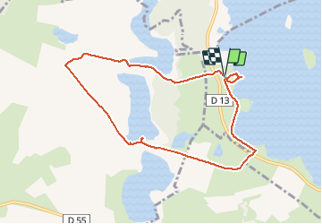
Tour Wandern von 8,1 km verfügbar auf Großer Osten, Marne, Giffaumont-Champaubert. Diese Tour wird von GerardBouche vorgeschlagen.
Beschreibung
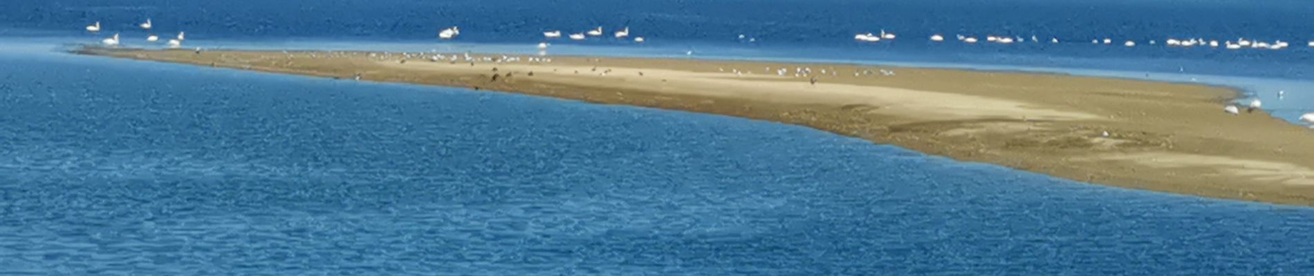
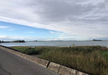
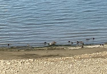
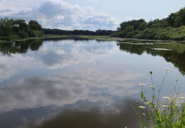
Depuis le site de Chantecoq, un petit sentier ombragé vous emmène à la découverte des étangs des Landres, du Grand Coulon et de la forêt. Un observatoire sur le parcours ... ne pas oublier les jumelles !
Ort
Land:
France
Region :
Großer Osten
Abteilung/Provinz :
Marne
Kommune :
Giffaumont-Champaubert
Standort:
Unknown
Gehen Sie:(Dec)
Gehen Sie:(UTM)
625642 ; 5380971 (31U) N.
Kommentare
Touren in der Umgebung
![Tour Wandern Giffaumont-Champaubert - Voyage autour des Etangs - Photo](https://media.geolcdn.com/t/375/260/ext.jpg?maxdim=2&url=https%3A%2F%2Fstatic1.geolcdn.com%2Fsiteimages%2Fupload%2Ffiles%2F1553511878bg_sport_marche.png)
![Wandern Wandern](https://static1.geolcdn.com/sitytour/trail-icons/101.png)
Voyage autour des Etangs
Wandern
Einfach
(2)
Giffaumont-Champaubert,
Großer Osten,
Marne,
France
![](/images/other/stat-length.png)
7,2 km | 8 km-effort
1h 30min
![](https://static1.geolcdn.com/siteimages/upload/files/16400158638029165_repeat_loop_refresh_sync_direction_icon.png)
Ja
![Tour Zu Fuß Giffaumont-Champaubert - Circuit des Étangs d'Outines - Photo](https://media.geolcdn.com/t/375/260/c97e5221-43ba-460a-8b85-afd25566fc45.jpeg&format=jpg&maxdim=2)
![Zu Fuß Zu Fuß](https://static1.geolcdn.com/sitytour/trail-icons/100.png)
Circuit des Étangs d'Outines
Zu Fuß
Einfach
Giffaumont-Champaubert,
Großer Osten,
Marne,
France
![](/images/other/stat-length.png)
6,2 km | 6,7 km-effort
1h 31min
![](https://static1.geolcdn.com/siteimages/upload/files/16400158638029165_repeat_loop_refresh_sync_direction_icon.png)
Nein
![Tour Wandern Giffaumont-Champaubert - LAC dur DER ... la forêt, la terre et l'eau. - Photo](https://media.geolcdn.com/t/375/260/16ddca7d-e5a5-4726-a093-703886190c99.jpg&format=jpg&maxdim=2)
![Wandern Wandern](https://static1.geolcdn.com/sitytour/trail-icons/101.png)
LAC dur DER ... la forêt, la terre et l'eau.
Wandern
Sehr leicht
Giffaumont-Champaubert,
Großer Osten,
Marne,
France
![](/images/other/stat-length.png)
13,5 km | 14,9 km-effort
3h 32min
![](https://static1.geolcdn.com/siteimages/upload/files/16400158638029165_repeat_loop_refresh_sync_direction_icon.png)
Ja
![Tour Wandern Outines - près de outine - Photo](https://media.geolcdn.com/t/375/260/ext.jpg?maxdim=2&url=https%3A%2F%2Fstatic1.geolcdn.com%2Fsiteimages%2Fupload%2Ffiles%2F1553511878bg_sport_marche.png)
![Wandern Wandern](https://static1.geolcdn.com/sitytour/trail-icons/101.png)
près de outine
Wandern
Einfach
(1)
Outines,
Großer Osten,
Marne,
France
![](/images/other/stat-length.png)
7,8 km | 8,6 km-effort
2h 26min
![](https://static1.geolcdn.com/siteimages/upload/files/16400158638029165_repeat_loop_refresh_sync_direction_icon.png)
Ja
![Tour Wandern Giffaumont-Champaubert - lac du der - Photo](https://media.geolcdn.com/t/375/260/a2a32ad6-c50c-4066-848f-0c39f2554faa.jpg&format=jpg&maxdim=2)
![Wandern Wandern](https://static1.geolcdn.com/sitytour/trail-icons/101.png)
lac du der
Wandern
Einfach
Giffaumont-Champaubert,
Großer Osten,
Marne,
France
![](/images/other/stat-length.png)
5 km | 5,5 km-effort
2h 7min
![](https://static1.geolcdn.com/siteimages/upload/files/16400158638029165_repeat_loop_refresh_sync_direction_icon.png)
Ja
![Tour sport Giffaumont-Champaubert - Lac du Der Giffaumont. 17/10/2024 - Photo](https://media.geolcdn.com/t/375/260/1a9b1d86-ae35-4a73-a178-1b037d185480.jpg&format=jpg&maxdim=2)
Lac du Der Giffaumont. 17/10/2024
sport
Sehr leicht
(1)
Giffaumont-Champaubert,
Großer Osten,
Marne,
France
![](/images/other/stat-length.png)
10,8 km | 11,6 km-effort
Unbekannt
![](https://static1.geolcdn.com/siteimages/upload/files/16400158638029165_repeat_loop_refresh_sync_direction_icon.png)
Ja
![Tour sport Giffaumont-Champaubert - Lac du der marne - Photo](https://media.geolcdn.com/t/375/260/67577c8f-d5c4-4774-9adb-8fa823eba333.jpg&format=jpg&maxdim=2)
Lac du der marne
sport
Sehr leicht
Giffaumont-Champaubert,
Großer Osten,
Marne,
France
![](/images/other/stat-length.png)
12,9 km | 13,8 km-effort
Unbekannt
![](https://static1.geolcdn.com/siteimages/upload/files/16400158638029165_repeat_loop_refresh_sync_direction_icon.png)
Ja
![Tour Wandern Giffaumont-Champaubert - Le Der du 24-07-2024 après-midi - Photo](https://media.geolcdn.com/t/375/260/a447f8d6-20a5-4a72-ad72-ea3940b4a46d.jpg&format=jpg&maxdim=2)
![Wandern Wandern](https://static1.geolcdn.com/sitytour/trail-icons/101.png)
Le Der du 24-07-2024 après-midi
Wandern
Einfach
Giffaumont-Champaubert,
Großer Osten,
Marne,
France
![](/images/other/stat-length.png)
4 km | 4,4 km-effort
1h 0min
![](https://static1.geolcdn.com/siteimages/upload/files/16400158638029165_repeat_loop_refresh_sync_direction_icon.png)
Ja
![Tour Wandern Giffaumont-Champaubert - Le Der du 24-07-2024 les étangs d'Outines - Photo](https://media.geolcdn.com/t/375/260/329f329c-a4de-4923-998d-799d7d582e49.jpg&format=jpg&maxdim=2)
![Wandern Wandern](https://static1.geolcdn.com/sitytour/trail-icons/101.png)
Le Der du 24-07-2024 les étangs d'Outines
Wandern
Medium
Giffaumont-Champaubert,
Großer Osten,
Marne,
France
![](/images/other/stat-length.png)
7,9 km | 8,8 km-effort
2h 1min
![](https://static1.geolcdn.com/siteimages/upload/files/16400158638029165_repeat_loop_refresh_sync_direction_icon.png)
Ja