![](/images/other/stat-length.png)
![Tour Wandern Le Tilleul - Le Tilleul - Jumel - Etretat - Photo](https://media.geolcdn.com/t/1900/400/dfc79e4a-8b15-4f8a-8eec-e0e894a1de8b.jpg&format=pjpeg&maxdim=2)
Le Tilleul - Jumel - Etretat
DDLEDANDY
Benutzer
![Länge](/images/other/stat-length.png)
Länge
12,2 km
![Maximale Höhe](https://static1.geolcdn.com/siteimages/upload/files/1508320355ic_sort_altitude_max_24dp.png)
Maximale Höhe
109 m
![Positive Höhendifferenz](https://static1.geolcdn.com/siteimages/upload/files/1508320355ic_sort_den_pos_24dp.png)
Positive Höhendifferenz
249 m
![Km-Effort](/images/other/stat-length.png)
Km-Effort
15,5 km
![Min. Höhe](https://static1.geolcdn.com/siteimages/upload/files/1508320355ic_sort_altitude_min_24dp.png)
Min. Höhe
7 m
![Negative Höhendifferenz](https://static1.geolcdn.com/siteimages/upload/files/1508320355ic_sort_den_neg_24dp.png)
Negative Höhendifferenz
250 m
![Boucle](https://static1.geolcdn.com/siteimages/upload/files/16400158638029165_repeat_loop_refresh_sync_direction_icon.png)
Boucle
Ja
Erstellungsdatum :
2020-09-01 07:13:20.187
Letzte Änderung :
2020-09-01 10:03:06.413
![Wandern](https://static1.geolcdn.com/sitytour/trail-icons/101.png)
2h46
Schwierigkeit : Einfach
![Scannen Sie diesen QR-Code, um die Tour in der SityTrail-Anwendung zu öffnen](https://capi.geolives.com/qq0zvz2zws4bq2lad0pu/sitytour/trails/2534352/qr.png?size=200)
Kostenlosegpshiking-Anwendung
Über SityTrail
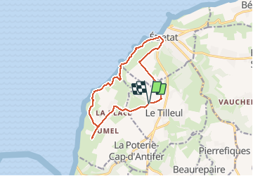
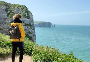
Tour Wandern von 12,2 km verfügbar auf Normandie, Seine-Maritime, Le Tilleul. Diese Tour wird von DDLEDANDY vorgeschlagen.
Beschreibung
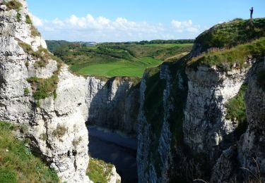
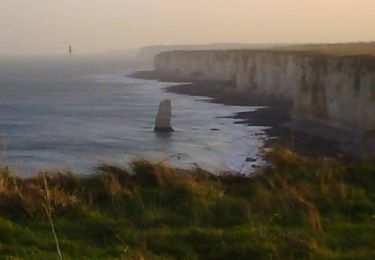
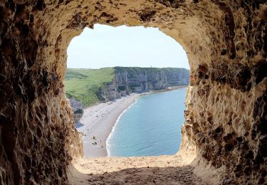
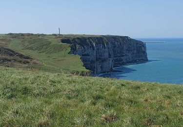
Parcours très sympathique qui permet de profiter de nombreux points de vue sur mer et côte d'Albâtre sur le tiers du parcours
Ort
Land:
France
Region :
Normandie
Abteilung/Provinz :
Seine-Maritime
Kommune :
Le Tilleul
Standort:
Unknown
Gehen Sie:(Dec)
Gehen Sie:(UTM)
297758 ; 5507533 (31U) N.
Kommentare
Touren in der Umgebung
![Tour Wandern Étretat - étretat golf - Photo](https://media.geolcdn.com/t/375/260/ext.jpg?maxdim=2&url=https%3A%2F%2Fservices.sitytrail.com%2FGeolivesWS%2FDownloadMedia.ashx%3FTrailID%3D302991%26Media%3Dfix__20140518154039.jpg)
![Wandern Wandern](https://static1.geolcdn.com/sitytour/trail-icons/101.png)
étretat golf
Wandern
Einfach
(1)
Étretat,
Normandie,
Seine-Maritime,
France
![](/images/other/stat-length.png)
4,7 km | 6,7 km-effort
1h 42min
![](https://static1.geolcdn.com/siteimages/upload/files/16400158638029165_repeat_loop_refresh_sync_direction_icon.png)
Ja
![Tour Wandern Étretat - Le sentier nature des falaises d'Etretat - Photo](https://media.geolcdn.com/t/375/260/ext.jpg?maxdim=2&url=https%3A%2F%2Fservices.sitytrail.com%2FGeolivesWS%2FDownloadMedia.ashx%3FTrailID%3D172695%26Media%3D14074_5.jpg)
![Wandern Wandern](https://static1.geolcdn.com/sitytour/trail-icons/101.png)
Le sentier nature des falaises d'Etretat
Wandern
Medium
(2)
Étretat,
Normandie,
Seine-Maritime,
France
![](/images/other/stat-length.png)
9,3 km | 12,7 km-effort
3h 30min
![](https://static1.geolcdn.com/siteimages/upload/files/16400158638029165_repeat_loop_refresh_sync_direction_icon.png)
Ja
![Tour Mountainbike Étretat - Etretat Yport - Photo](https://media.geolcdn.com/t/375/260/ext.jpg?maxdim=2&url=https%3A%2F%2Fservices.sitytrail.com%2FGeolivesWS%2FDownloadMedia.ashx%3FTrailID%3D104928%26Media%3D8466_1.jpg)
![Mountainbike Mountainbike](https://static1.geolcdn.com/sitytour/trail-icons/202.png)
Etretat Yport
Mountainbike
Schwierig
(4)
Étretat,
Normandie,
Seine-Maritime,
France
![](/images/other/stat-length.png)
35 km | 43 km-effort
3h 0min
![](https://static1.geolcdn.com/siteimages/upload/files/16400158638029165_repeat_loop_refresh_sync_direction_icon.png)
Ja
![Tour Wandern Le Tilleul - La Valleuse d'Antifer - Photo](https://media.geolcdn.com/t/375/260/5e0af125-3ee6-4ef5-8573-7b5656fc4a5d.jpg&format=jpg&maxdim=2)
![Wandern Wandern](https://static1.geolcdn.com/sitytour/trail-icons/101.png)
La Valleuse d'Antifer
Wandern
Schwierig
(1)
Le Tilleul,
Normandie,
Seine-Maritime,
France
![](/images/other/stat-length.png)
12,5 km | 16,3 km-effort
3h 42min
![](https://static1.geolcdn.com/siteimages/upload/files/16400158638029165_repeat_loop_refresh_sync_direction_icon.png)
Ja
![Tour Wandern La Poterie-Cap-d'Antifer - Etretat - Photo](https://media.geolcdn.com/t/375/260/ext.jpg?maxdim=2&url=https%3A%2F%2Fstatic1.geolcdn.com%2Fsiteimages%2Fupload%2Ffiles%2F1553511878bg_sport_marche.png)
![Wandern Wandern](https://static1.geolcdn.com/sitytour/trail-icons/101.png)
Etretat
Wandern
Einfach
(1)
La Poterie-Cap-d'Antifer,
Normandie,
Seine-Maritime,
France
![](/images/other/stat-length.png)
10,6 km | 14,4 km-effort
3h 8min
![](https://static1.geolcdn.com/siteimages/upload/files/16400158638029165_repeat_loop_refresh_sync_direction_icon.png)
Ja
![Tour Wandern Étretat - Etretat les falaises - Photo](https://media.geolcdn.com/t/375/260/ext.jpg?maxdim=2&url=https%3A%2F%2Fstatic1.geolcdn.com%2Fsiteimages%2Fupload%2Ffiles%2F1553511878bg_sport_marche.png)
![Wandern Wandern](https://static1.geolcdn.com/sitytour/trail-icons/101.png)
Etretat les falaises
Wandern
Einfach
(1)
Étretat,
Normandie,
Seine-Maritime,
France
![](/images/other/stat-length.png)
7,6 km | 10,2 km-effort
2h 56min
![](https://static1.geolcdn.com/siteimages/upload/files/16400158638029165_repeat_loop_refresh_sync_direction_icon.png)
Ja
![Tour Wandern Étretat - GR21 Etretat à Fécamp - Photo](https://media.geolcdn.com/t/375/260/ext.jpg?maxdim=2&url=https%3A%2F%2Fstatic1.geolcdn.com%2Fsiteimages%2Fupload%2Ffiles%2F1553511878bg_sport_marche.png)
![Wandern Wandern](https://static1.geolcdn.com/sitytour/trail-icons/101.png)
GR21 Etretat à Fécamp
Wandern
Einfach
(1)
Étretat,
Normandie,
Seine-Maritime,
France
![](/images/other/stat-length.png)
16,4 km | 21 km-effort
4h 42min
![](https://static1.geolcdn.com/siteimages/upload/files/16400158638029165_repeat_loop_refresh_sync_direction_icon.png)
Nein
![Tour Wandern Bénouville - L'aiguille de Belval - Photo](https://media.geolcdn.com/t/375/260/e5015acf-207d-4f0a-9245-b6a712853198.jpg&format=jpg&maxdim=2)
![Wandern Wandern](https://static1.geolcdn.com/sitytour/trail-icons/101.png)
L'aiguille de Belval
Wandern
Medium
Bénouville,
Normandie,
Seine-Maritime,
France
![](/images/other/stat-length.png)
9 km | 11,1 km-effort
2h 31min
![](https://static1.geolcdn.com/siteimages/upload/files/16400158638029165_repeat_loop_refresh_sync_direction_icon.png)
Ja
![Tour Wandern Étretat - Falaise d'Etretat - Photo](https://media.geolcdn.com/t/375/260/f69257bf-8597-4797-8e18-5f418d814afc.jpg&format=jpg&maxdim=2)
![Wandern Wandern](https://static1.geolcdn.com/sitytour/trail-icons/101.png)
Falaise d'Etretat
Wandern
Einfach
Étretat,
Normandie,
Seine-Maritime,
France
![](/images/other/stat-length.png)
9 km | 11,8 km-effort
2h 19min
![](https://static1.geolcdn.com/siteimages/upload/files/16400158638029165_repeat_loop_refresh_sync_direction_icon.png)
Ja