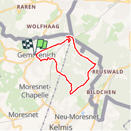
![](/images/other/stat-length.png)
![Tour Wandern Bleiberg - Promenade des Trois Bornes (9,5km) - Photo](https://media.geolcdn.com/t/1900/400/ext.pjpeg?maxdim=2&url=https%3A%2F%2Fstatic1.geolcdn.com%2Fsiteimages%2Fupload%2Ffiles%2F1553511878bg_sport_marche.png)
Promenade des Trois Bornes (9,5km)
Maison du Tourisme du pays de Herve
Randonnées de la Maison du Tourisme du Pays de Herve GUIDE+
![Länge](/images/other/stat-length.png)
![Maximale Höhe](https://static1.geolcdn.com/siteimages/upload/files/1508320355ic_sort_altitude_max_24dp.png)
![Positive Höhendifferenz](https://static1.geolcdn.com/siteimages/upload/files/1508320355ic_sort_den_pos_24dp.png)
![Km-Effort](/images/other/stat-length.png)
![Min. Höhe](https://static1.geolcdn.com/siteimages/upload/files/1508320355ic_sort_altitude_min_24dp.png)
![Negative Höhendifferenz](https://static1.geolcdn.com/siteimages/upload/files/1508320355ic_sort_den_neg_24dp.png)
![Boucle](https://static1.geolcdn.com/siteimages/upload/files/16400158638029165_repeat_loop_refresh_sync_direction_icon.png)
![Wandern](https://static1.geolcdn.com/sitytour/trail-icons/101.png)
--
Schwierigkeit : Unbekannt
![Scannen Sie diesen QR-Code, um die Tour in der SityTrail-Anwendung zu öffnen](https://capi.geolives.com/qq0zvz2zws4bq2lad0pu/sitytour/trails/253130/qr.png?size=200)
Kostenlosegpshiking-Anwendung
Über SityTrail
Tour Wandern von 9,6 km verfügbar auf Wallonien, Lüttich, Bleiberg. Diese Tour wird von Maison du Tourisme du pays de Herve vorgeschlagen.
Beschreibung
Les Trois Frontières est le point de rencontre entre la Belgique, les Pays Bas et l''Allemagne, et, de 1839 à 1919, de l''ancien territoire de "MORESNET-NEUTRE" (aujourd''hui La Calamine). Les trois bornes présentes sur le site ne le sont qu''à titre symbolique et se situent toutes trois en territoire néerlandais. En réalité, on découvrira le vrai point de rencontre des trois pays à la borne 193, près de la tour, marquée des trois lettres B(Belgique) D(Allemagne) et NL (Pays Bas).
Ort
Kommentare
Touren in der Umgebung
![Tour Wandern Kelmis - Le pays calaminaire - Photo](https://media.geolcdn.com/t/375/260/30655fe2-e81a-47ed-96f4-20092bed94b7.jpg&format=jpg&maxdim=2)
![Wandern Wandern](https://static1.geolcdn.com/sitytour/trail-icons/101.png)
Wandern
![](/images/other/stat-length.png)
![](https://static1.geolcdn.com/siteimages/upload/files/16400158638029165_repeat_loop_refresh_sync_direction_icon.png)
![Tour Wandern Vaals - 2023-04-07_19h11m12_788 - Photo](https://media.geolcdn.com/t/375/260/bd8f5c72-b581-4e46-b6f7-9a77fca5b16a.jpg&format=jpg&maxdim=2)
![Wandern Wandern](https://static1.geolcdn.com/sitytour/trail-icons/101.png)
Wandern
![](/images/other/stat-length.png)
![](https://static1.geolcdn.com/siteimages/upload/files/16400158638029165_repeat_loop_refresh_sync_direction_icon.png)
![Tour Wandern Vaals - 2023-04-07_19h07m33_235 - Photo](https://media.geolcdn.com/t/375/260/2b2b6b31-a826-484c-a3a8-d4c3abde9549.jpg&format=jpg&maxdim=2)
![Wandern Wandern](https://static1.geolcdn.com/sitytour/trail-icons/101.png)
Wandern
![](/images/other/stat-length.png)
![](https://static1.geolcdn.com/siteimages/upload/files/16400158638029165_repeat_loop_refresh_sync_direction_icon.png)
![Tour Wandern Kelmis - La Calamine - Photo](https://media.geolcdn.com/t/375/260/606e5792-434a-491a-b5eb-2bfc2ef6f1ed.jpg&format=jpg&maxdim=2)
![Wandern Wandern](https://static1.geolcdn.com/sitytour/trail-icons/101.png)
Wandern
![](/images/other/stat-length.png)
![](https://static1.geolcdn.com/siteimages/upload/files/16400158638029165_repeat_loop_refresh_sync_direction_icon.png)
![Tour Wandern Aachen - Aix-la-Chapelle - Photo](https://media.geolcdn.com/t/375/260/19678e47-68ef-4997-bad3-67eb75fafd82.jpg&format=jpg&maxdim=2)
![Wandern Wandern](https://static1.geolcdn.com/sitytour/trail-icons/101.png)
Wandern
![](/images/other/stat-length.png)
![](https://static1.geolcdn.com/siteimages/upload/files/16400158638029165_repeat_loop_refresh_sync_direction_icon.png)
![Tour Wandern Kelmis - 2022-01-18_14h17m25_kelmis - Photo](https://media.geolcdn.com/t/375/260/9eea9d75-ea39-4660-b255-7d2a2255555e.jpg&format=jpg&maxdim=2)
![Wandern Wandern](https://static1.geolcdn.com/sitytour/trail-icons/101.png)
Wandern
![](/images/other/stat-length.png)
![](https://static1.geolcdn.com/siteimages/upload/files/16400158638029165_repeat_loop_refresh_sync_direction_icon.png)
![Tour Wandern Vaals - 2021-07-14_08h55m00_1431 - Photo](https://media.geolcdn.com/t/375/260/be698cb8-a234-4803-8ecd-dfa4be54f61b.jpg&format=jpg&maxdim=2)
![Wandern Wandern](https://static1.geolcdn.com/sitytour/trail-icons/101.png)
Wandern
![](/images/other/stat-length.png)
![](https://static1.geolcdn.com/siteimages/upload/files/16400158638029165_repeat_loop_refresh_sync_direction_icon.png)
![Tour Wandern Raeren - 2021-04-02_18h39m41_975 - Photo](https://media.geolcdn.com/t/375/260/4dbde2fb-33e3-4e75-84b3-1404a45e04cc.jpg&format=jpg&maxdim=2)
![Wandern Wandern](https://static1.geolcdn.com/sitytour/trail-icons/101.png)
Wandern
![](/images/other/stat-length.png)
![](https://static1.geolcdn.com/siteimages/upload/files/16400158638029165_repeat_loop_refresh_sync_direction_icon.png)
![Tour Wandern Kelmis - 20200730 - Les 3 Bornes 7.3 Km - Photo](https://media.geolcdn.com/t/375/260/ab7b3f98-4235-4a73-ba70-1bedd5c785f3.jpg&format=jpg&maxdim=2)
![Wandern Wandern](https://static1.geolcdn.com/sitytour/trail-icons/101.png)
Wandern
![](/images/other/stat-length.png)
![](https://static1.geolcdn.com/siteimages/upload/files/16400158638029165_repeat_loop_refresh_sync_direction_icon.png)