![](/images/other/stat-length.png)
![Tour Mountainbike Salvan - WallisBike 03 Les Marecottes - Verbier - Photo](https://media.geolcdn.com/t/1900/400/ext.pjpeg?maxdim=2&url=https%3A%2F%2Fstatic1.geolcdn.com%2Fsiteimages%2Fupload%2Ffiles%2F1524743154velo.jpg)
WallisBike 03 Les Marecottes - Verbier
ovronne
Benutzer
![Länge](/images/other/stat-length.png)
Länge
48 km
![Maximale Höhe](https://static1.geolcdn.com/siteimages/upload/files/1508320355ic_sort_altitude_max_24dp.png)
Maximale Höhe
2347 m
![Positive Höhendifferenz](https://static1.geolcdn.com/siteimages/upload/files/1508320355ic_sort_den_pos_24dp.png)
Positive Höhendifferenz
3046 m
![Km-Effort](/images/other/stat-length.png)
Km-Effort
87 km
![Min. Höhe](https://static1.geolcdn.com/siteimages/upload/files/1508320355ic_sort_altitude_min_24dp.png)
Min. Höhe
495 m
![Negative Höhendifferenz](https://static1.geolcdn.com/siteimages/upload/files/1508320355ic_sort_den_neg_24dp.png)
Negative Höhendifferenz
2661 m
![Boucle](https://static1.geolcdn.com/siteimages/upload/files/16400158638029165_repeat_loop_refresh_sync_direction_icon.png)
Boucle
Nein
Erstellungsdatum :
2014-12-11 00:00:00.0
Letzte Änderung :
2014-12-11 00:00:00.0
![Mountainbike](https://static1.geolcdn.com/sitytour/trail-icons/202.png)
7h46
Schwierigkeit : Unbekannt
![Scannen Sie diesen QR-Code, um die Tour in der SityTrail-Anwendung zu öffnen](https://capi.geolives.com/qq0zvz2zws4bq2lad0pu/sitytour/trails/25097/qr.png?size=200)
Kostenlosegpshiking-Anwendung
Über SityTrail
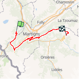
Tour Mountainbike von 48 km verfügbar auf Wallis, Sankt Moritz, Salvan. Diese Tour wird von ovronne vorgeschlagen.
Beschreibung
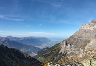
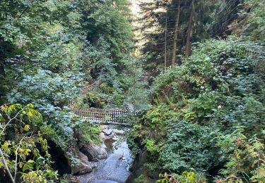
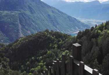
Troisième étape de la traversée des Alpes Suisse de St-Gingolph à Scuol.
Départe des Marécottes, montée vers Trient et le Col de la Forclaz.
Descente sur Martigny, montée direction Chemin, le Col des Planches, le Col du Lein et la Pierre Avoi.
Descente sur l''arrivée Verbier.
Ort
Land:
Switzerland
Region :
Wallis
Abteilung/Provinz :
Sankt Moritz
Kommune :
Salvan
Standort:
Unknown
Gehen Sie:(Dec)
Gehen Sie:(UTM)
345927 ; 5108353 (32T) N.
Kommentare
Touren in der Umgebung
![Tour Zu Fuß Martigny - Géoglyphe de Grande Tête - Photo](https://media.geolcdn.com/t/375/260/bef67359-bcde-421e-ab80-f0f245a262d6.jpeg&format=jpg&maxdim=2)
![Zu Fuß Zu Fuß](https://static1.geolcdn.com/sitytour/trail-icons/100.png)
Géoglyphe de Grande Tête
Zu Fuß
Einfach
Martigny,
Wallis,
Martinach,
Switzerland
![](/images/other/stat-length.png)
3,8 km | 4,5 km-effort
1h 0min
![](https://static1.geolcdn.com/siteimages/upload/files/16400158638029165_repeat_loop_refresh_sync_direction_icon.png)
Nein
![Tour Zu Fuß Martigny-Combe - Chemin pédestre de montagne, région Martigny - Photo](https://media.geolcdn.com/t/375/260/bed65172-7217-48ce-88ff-bc4aa3ca0006.jpeg&format=jpg&maxdim=2)
![Zu Fuß Zu Fuß](https://static1.geolcdn.com/sitytour/trail-icons/100.png)
Chemin pédestre de montagne, région Martigny
Zu Fuß
Einfach
Martigny-Combe,
Wallis,
Martinach,
Switzerland
![](/images/other/stat-length.png)
3,9 km | 10,8 km-effort
2h 27min
![](https://static1.geolcdn.com/siteimages/upload/files/16400158638029165_repeat_loop_refresh_sync_direction_icon.png)
Nein
![Tour Zu Fuß Salvan - Tour du Vallon de Van - Photo](https://media.geolcdn.com/t/375/260/7c24bf3d-9c77-4982-9b22-de277e75b752.jpeg&format=jpg&maxdim=2)
![Zu Fuß Zu Fuß](https://static1.geolcdn.com/sitytour/trail-icons/100.png)
Tour du Vallon de Van
Zu Fuß
Einfach
Salvan,
Wallis,
Sankt Moritz,
Switzerland
![](/images/other/stat-length.png)
6,7 km | 11,3 km-effort
2h 34min
![](https://static1.geolcdn.com/siteimages/upload/files/16400158638029165_repeat_loop_refresh_sync_direction_icon.png)
Ja
![Tour Wandern Dorénaz - le Diabley - Photo](https://media.geolcdn.com/t/375/260/60e318b6-2b8d-4887-8d86-bf3d436e082f.jpg&format=jpg&maxdim=2)
![Wandern Wandern](https://static1.geolcdn.com/sitytour/trail-icons/101.png)
le Diabley
Wandern
Medium
Dorénaz,
Wallis,
Sankt Moritz,
Switzerland
![](/images/other/stat-length.png)
13,3 km | 31 km-effort
4h 36min
![](https://static1.geolcdn.com/siteimages/upload/files/16400158638029165_repeat_loop_refresh_sync_direction_icon.png)
Ja
![Tour Wandern Salvan - Les gorges à Martigny - Photo](https://media.geolcdn.com/t/375/260/025ef769-e08e-4ddc-a583-500a79aae8e5.jpg&format=jpg&maxdim=2)
![Wandern Wandern](https://static1.geolcdn.com/sitytour/trail-icons/101.png)
Les gorges à Martigny
Wandern
Schwierig
Salvan,
Wallis,
Sankt Moritz,
Switzerland
![](/images/other/stat-length.png)
10,5 km | 17,7 km-effort
2h 34min
![](https://static1.geolcdn.com/siteimages/upload/files/16400158638029165_repeat_loop_refresh_sync_direction_icon.png)
Nein
![Tour Wandern Salvan - Sentier Nature - Rochers du Soir - Photo](https://media.geolcdn.com/t/375/260/ext.jpg?maxdim=2&url=https%3A%2F%2Fstatic1.geolcdn.com%2Fsiteimages%2Fupload%2Ffiles%2F1553511878bg_sport_marche.png)
![Wandern Wandern](https://static1.geolcdn.com/sitytour/trail-icons/101.png)
Sentier Nature - Rochers du Soir
Wandern
Sehr leicht
Salvan,
Wallis,
Sankt Moritz,
Switzerland
![](/images/other/stat-length.png)
3,6 km | 6 km-effort
Unbekannt
![](https://static1.geolcdn.com/siteimages/upload/files/16400158638029165_repeat_loop_refresh_sync_direction_icon.png)
Ja
![Tour Wandern Martigny - vs_hike817a - Photo](https://media.geolcdn.com/t/375/260/ext.jpg?maxdim=2&url=https%3A%2F%2Fstatic1.geolcdn.com%2Fsiteimages%2Fupload%2Ffiles%2F1553511878bg_sport_marche.png)
![Wandern Wandern](https://static1.geolcdn.com/sitytour/trail-icons/101.png)
vs_hike817a
Wandern
Sehr leicht
Martigny,
Wallis,
Martinach,
Switzerland
![](/images/other/stat-length.png)
5,7 km | 8,7 km-effort
1h 37min
![](https://static1.geolcdn.com/siteimages/upload/files/16400158638029165_repeat_loop_refresh_sync_direction_icon.png)
Ja
![Tour Wandern Martigny-Combe - les raperins à l'alpage d'Arpille - Photo](https://media.geolcdn.com/t/375/260/ext.jpg?maxdim=2&url=https%3A%2F%2Fstatic1.geolcdn.com%2Fsiteimages%2Fupload%2Ffiles%2F1553511878bg_sport_marche.png)
![Wandern Wandern](https://static1.geolcdn.com/sitytour/trail-icons/101.png)
les raperins à l'alpage d'Arpille
Wandern
Schwierig
Martigny-Combe,
Wallis,
Martinach,
Switzerland
![](/images/other/stat-length.png)
4,3 km | 11,3 km-effort
1h 27min
![](https://static1.geolcdn.com/siteimages/upload/files/16400158638029165_repeat_loop_refresh_sync_direction_icon.png)
Nein
![Tour Wandern Salvan - Gorges du Dailley - marmites glacières 23.05.17 - Photo](https://media.geolcdn.com/t/375/260/ext.jpg?maxdim=2&url=https%3A%2F%2Fservices.sitytrail.com%2FGeolivesWS%2FDownloadMedia.ashx%3FTrailID%3D758410%26Media%3D6da60f99-40b0-4807-9bbb-0b6fdda625b6.jpg)
![Wandern Wandern](https://static1.geolcdn.com/sitytour/trail-icons/101.png)
Gorges du Dailley - marmites glacières 23.05.17
Wandern
Medium
Salvan,
Wallis,
Sankt Moritz,
Switzerland
![](/images/other/stat-length.png)
8,1 km | 14,8 km-effort
3h 9min
![](https://static1.geolcdn.com/siteimages/upload/files/16400158638029165_repeat_loop_refresh_sync_direction_icon.png)
Ja