![](/images/other/stat-length.png)
![Tour Mountainbike Savines-le-Lac - eygoires boscodon sentier GR retour partiel route - Photo](https://media.geolcdn.com/t/1900/400/ext.pjpeg?maxdim=2&url=https%3A%2F%2Fstatic1.geolcdn.com%2Fsiteimages%2Fupload%2Ffiles%2F1524743154velo.jpg)
eygoires boscodon sentier GR retour partiel route
guariso
Benutzer
![Länge](/images/other/stat-length.png)
Länge
23 km
![Maximale Höhe](https://static1.geolcdn.com/siteimages/upload/files/1508320355ic_sort_altitude_max_24dp.png)
Maximale Höhe
1110 m
![Positive Höhendifferenz](https://static1.geolcdn.com/siteimages/upload/files/1508320355ic_sort_den_pos_24dp.png)
Positive Höhendifferenz
611 m
![Km-Effort](/images/other/stat-length.png)
Km-Effort
31 km
![Min. Höhe](https://static1.geolcdn.com/siteimages/upload/files/1508320355ic_sort_altitude_min_24dp.png)
Min. Höhe
776 m
![Negative Höhendifferenz](https://static1.geolcdn.com/siteimages/upload/files/1508320355ic_sort_den_neg_24dp.png)
Negative Höhendifferenz
610 m
![Boucle](https://static1.geolcdn.com/siteimages/upload/files/16400158638029165_repeat_loop_refresh_sync_direction_icon.png)
Boucle
Ja
Erstellungsdatum :
2020-08-10 06:49:15.383
Letzte Änderung :
2020-08-10 09:40:43.305
![Mountainbike](https://static1.geolcdn.com/sitytour/trail-icons/202.png)
2h45
Schwierigkeit : Medium
![Scannen Sie diesen QR-Code, um die Tour in der SityTrail-Anwendung zu öffnen](https://capi.geolives.com/qq0zvz2zws4bq2lad0pu/sitytour/trails/2508936/qr.png?size=200)
Kostenlosegpshiking-Anwendung
Über SityTrail
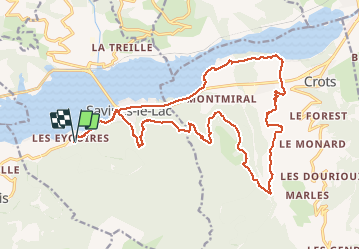
Tour Mountainbike von 23 km verfügbar auf Provence-Alpes-Côte d'Azur, Hochalpen, Savines-le-Lac. Diese Tour wird von guariso vorgeschlagen.
Beschreibung
descente GR pas facile possibilité de descendre par la route.
traversée du boscodon possible seulement en été, sinon contourner.
Ort
Land:
France
Region :
Provence-Alpes-Côte d'Azur
Abteilung/Provinz :
Hochalpen
Kommune :
Savines-le-Lac
Standort:
Unknown
Gehen Sie:(Dec)
Gehen Sie:(UTM)
292327 ; 4932722 (32T) N.
Kommentare
Touren in der Umgebung
![Tour Wandern Crots - Le Cirque de Morgon - Photo](https://media.geolcdn.com/t/375/260/ext.jpg?maxdim=2&url=https%3A%2F%2Fservices.sitytrail.com%2FGeolivesWS%2FDownloadMedia.ashx%3FTrailID%3D109626%26Media%3D4261_1.jpg)
![Wandern Wandern](https://static1.geolcdn.com/sitytour/trail-icons/101.png)
Le Cirque de Morgon
Wandern
Schwierig
(5)
Crots,
Provence-Alpes-Côte d'Azur,
Hochalpen,
France
![](/images/other/stat-length.png)
10,6 km | 21 km-effort
5h 30min
![](https://static1.geolcdn.com/siteimages/upload/files/16400158638029165_repeat_loop_refresh_sync_direction_icon.png)
Ja
![Tour Wandern Pontis - PONTIS , le dolmen - Photo](https://media.geolcdn.com/t/375/260/d93d41b4-eb7a-4763-938e-68a4d680a655.jpg&format=jpg&maxdim=2)
![Wandern Wandern](https://static1.geolcdn.com/sitytour/trail-icons/101.png)
PONTIS , le dolmen
Wandern
Medium
(1)
Pontis,
Provence-Alpes-Côte d'Azur,
Alpes-de-Haute-Provence,
France
![](/images/other/stat-length.png)
12,9 km | 21 km-effort
3h 50min
![](https://static1.geolcdn.com/siteimages/upload/files/16400158638029165_repeat_loop_refresh_sync_direction_icon.png)
Ja
![Tour Wandern Crots - Morgon par le Grand Clot - Photo](https://media.geolcdn.com/t/375/260/2470b249-9732-40d6-87a8-fc728b4285cc.jpg&format=jpg&maxdim=2)
![Wandern Wandern](https://static1.geolcdn.com/sitytour/trail-icons/101.png)
Morgon par le Grand Clot
Wandern
Einfach
(1)
Crots,
Provence-Alpes-Côte d'Azur,
Hochalpen,
France
![](/images/other/stat-length.png)
11,8 km | 22 km-effort
5h 49min
![](https://static1.geolcdn.com/siteimages/upload/files/16400158638029165_repeat_loop_refresh_sync_direction_icon.png)
Ja
![Tour Wandern Pontis - pic de Morgon par les ortals et les traverses - Photo](https://media.geolcdn.com/t/375/260/cb777f72-56d2-4b64-b456-51d964e0cfaa.jpg&format=jpg&maxdim=2)
![Wandern Wandern](https://static1.geolcdn.com/sitytour/trail-icons/101.png)
pic de Morgon par les ortals et les traverses
Wandern
Schwierig
Pontis,
Provence-Alpes-Côte d'Azur,
Alpes-de-Haute-Provence,
France
![](/images/other/stat-length.png)
12,3 km | 26 km-effort
8h 49min
![](https://static1.geolcdn.com/siteimages/upload/files/16400158638029165_repeat_loop_refresh_sync_direction_icon.png)
Ja
![Tour Wandern Pontis - Le Grand Morgon par la face nord 07/09/23 - Photo](https://media.geolcdn.com/t/375/260/a64e7d52-33b6-427f-a518-e6356f0ffab5.jpg&format=jpg&maxdim=2)
![Wandern Wandern](https://static1.geolcdn.com/sitytour/trail-icons/101.png)
Le Grand Morgon par la face nord 07/09/23
Wandern
Schwierig
Pontis,
Provence-Alpes-Côte d'Azur,
Alpes-de-Haute-Provence,
France
![](/images/other/stat-length.png)
7,8 km | 18,9 km-effort
4h 18min
![](https://static1.geolcdn.com/siteimages/upload/files/16400158638029165_repeat_loop_refresh_sync_direction_icon.png)
Ja
![Tour Wandern Crots - Grand Morgon - Photo](https://media.geolcdn.com/t/375/260/c2ea8bef-d143-4c62-a26e-6fbe8e0329c8.jpg&format=jpg&maxdim=2)
![Wandern Wandern](https://static1.geolcdn.com/sitytour/trail-icons/101.png)
Grand Morgon
Wandern
Medium
Crots,
Provence-Alpes-Côte d'Azur,
Hochalpen,
France
![](/images/other/stat-length.png)
11,4 km | 22 km-effort
4h 56min
![](https://static1.geolcdn.com/siteimages/upload/files/16400158638029165_repeat_loop_refresh_sync_direction_icon.png)
Ja
![Tour Wandern Crots - SityTrail - 2251353 - morgon-par-le-grand-clot - Photo](https://media.geolcdn.com/t/375/260/1bb998f8-1a6a-4350-bb2c-9f136211e7d5.jpg&format=jpg&maxdim=2)
![Wandern Wandern](https://static1.geolcdn.com/sitytour/trail-icons/101.png)
SityTrail - 2251353 - morgon-par-le-grand-clot
Wandern
Medium
Crots,
Provence-Alpes-Côte d'Azur,
Hochalpen,
France
![](/images/other/stat-length.png)
11,8 km | 22 km-effort
5h 30min
![](https://static1.geolcdn.com/siteimages/upload/files/16400158638029165_repeat_loop_refresh_sync_direction_icon.png)
Ja
![Tour Wandern Pontis - Morgon par les Traverses, retour par les Ortals - Photo](https://media.geolcdn.com/t/375/260/11e2532a-2629-4e4d-ad92-dc03a7dece44.jpg&format=jpg&maxdim=2)
![Wandern Wandern](https://static1.geolcdn.com/sitytour/trail-icons/101.png)
Morgon par les Traverses, retour par les Ortals
Wandern
Sehr schwierig
Pontis,
Provence-Alpes-Côte d'Azur,
Alpes-de-Haute-Provence,
France
![](/images/other/stat-length.png)
17,1 km | 33 km-effort
5h 49min
![](https://static1.geolcdn.com/siteimages/upload/files/16400158638029165_repeat_loop_refresh_sync_direction_icon.png)
Nein
![Tour Wandern Pontis - Le Morgonnet - Photo](https://media.geolcdn.com/t/375/260/c7e993fb-0242-4eef-8121-d454bffdb753.jpg&format=jpg&maxdim=2)
![Wandern Wandern](https://static1.geolcdn.com/sitytour/trail-icons/101.png)
Le Morgonnet
Wandern
Medium
Pontis,
Provence-Alpes-Côte d'Azur,
Alpes-de-Haute-Provence,
France
![](/images/other/stat-length.png)
5,9 km | 10,6 km-effort
2h 46min
![](https://static1.geolcdn.com/siteimages/upload/files/16400158638029165_repeat_loop_refresh_sync_direction_icon.png)
Ja