![](/images/other/stat-length.png)
![Tour Mountainbike Binn - WallisBike 09 Binn - Ulrichen - Photo](https://media.geolcdn.com/t/1900/400/ext.pjpeg?maxdim=2&url=https%3A%2F%2Fstatic1.geolcdn.com%2Fsiteimages%2Fupload%2Ffiles%2F1524743154velo.jpg)
WallisBike 09 Binn - Ulrichen
ovronne
Benutzer
![Länge](/images/other/stat-length.png)
Länge
36 km
![Maximale Höhe](https://static1.geolcdn.com/siteimages/upload/files/1508320355ic_sort_altitude_max_24dp.png)
Maximale Höhe
2655 m
![Positive Höhendifferenz](https://static1.geolcdn.com/siteimages/upload/files/1508320355ic_sort_den_pos_24dp.png)
Positive Höhendifferenz
1762 m
![Km-Effort](/images/other/stat-length.png)
Km-Effort
60 km
![Min. Höhe](https://static1.geolcdn.com/siteimages/upload/files/1508320355ic_sort_altitude_min_24dp.png)
Min. Höhe
1266 m
![Negative Höhendifferenz](https://static1.geolcdn.com/siteimages/upload/files/1508320355ic_sort_den_neg_24dp.png)
Negative Höhendifferenz
1821 m
![Boucle](https://static1.geolcdn.com/siteimages/upload/files/16400158638029165_repeat_loop_refresh_sync_direction_icon.png)
Boucle
Nein
Erstellungsdatum :
2014-12-11 00:00:00.0
Letzte Änderung :
2014-12-11 00:00:00.0
![Mountainbike](https://static1.geolcdn.com/sitytour/trail-icons/202.png)
8h30
Schwierigkeit : Unbekannt
![Scannen Sie diesen QR-Code, um die Tour in der SityTrail-Anwendung zu öffnen](https://capi.geolives.com/qq0zvz2zws4bq2lad0pu/sitytour/trails/25059/qr.png?size=200)
Kostenlosegpshiking-Anwendung
Über SityTrail
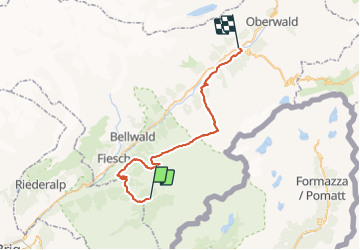
Tour Mountainbike von 36 km verfügbar auf Wallis, Goms, Binn. Diese Tour wird von ovronne vorgeschlagen.
Beschreibung
Neuvième étape de la traversée des Alpes Suisse de St-Gingolph à Scuol.
Départ de Binn, descente vers Ausserbinn. Direction le Rappetal et montée jusqu''au Chummefurgge. Descente du Blinnental jusqu''à Reckingen et direction Ulrichen.
Ort
Land:
Switzerland
Region :
Wallis
Abteilung/Provinz :
Goms
Kommune :
Binn
Standort:
Unknown
Gehen Sie:(Dec)
Gehen Sie:(UTM)
437348 ; 5134866 (32T) N.
Kommentare
Touren in der Umgebung
![Tour Zu Fuß Ernen - Mühlebach-Niederwald - Photo](https://media.geolcdn.com/t/375/260/29e6dc00-4e1f-444c-baf1-1548b7a6c9f2.jpeg&format=jpg&maxdim=2)
![Zu Fuß Zu Fuß](https://static1.geolcdn.com/sitytour/trail-icons/100.png)
Mühlebach-Niederwald
Zu Fuß
Einfach
Ernen,
Wallis,
Goms,
Switzerland
![](/images/other/stat-length.png)
4,6 km | 6,2 km-effort
1h 24min
![](https://static1.geolcdn.com/siteimages/upload/files/16400158638029165_repeat_loop_refresh_sync_direction_icon.png)
Nein
![Tour Zu Fuß Binn - Binn-Ausserbinn - Photo](https://media.geolcdn.com/t/375/260/ext.jpg?maxdim=2&url=https%3A%2F%2Fstatic1.geolcdn.com%2Fsiteimages%2Fupload%2Ffiles%2F1545311037marcheuse_200dpi.jpg)
![Zu Fuß Zu Fuß](https://static1.geolcdn.com/sitytour/trail-icons/100.png)
![Tour Zu Fuß Ernen - Ausserbinn-Ernen - Photo](https://media.geolcdn.com/t/375/260/ext.jpg?maxdim=2&url=https%3A%2F%2Fstatic1.geolcdn.com%2Fsiteimages%2Fupload%2Ffiles%2F1545311037marcheuse_200dpi.jpg)
![Zu Fuß Zu Fuß](https://static1.geolcdn.com/sitytour/trail-icons/100.png)
Ausserbinn-Ernen
Zu Fuß
Einfach
Ernen,
Wallis,
Goms,
Switzerland
![](/images/other/stat-length.png)
3,3 km | 4,6 km-effort
1h 2min
![](https://static1.geolcdn.com/siteimages/upload/files/16400158638029165_repeat_loop_refresh_sync_direction_icon.png)
Nein
![Tour Andere Aktivitäten Binn - y10_eggerhorn - Photo](https://media.geolcdn.com/t/375/260/ext.jpg?maxdim=2&url=https%3A%2F%2Fstatic1.geolcdn.com%2Fsiteimages%2Fupload%2Ffiles%2F1545311037marcheuse_200dpi.jpg)
![Andere Aktivitäten Andere Aktivitäten](https://static1.geolcdn.com/sitytour/trail-icons/900.png)
y10_eggerhorn
Andere Aktivitäten
Sehr leicht
Binn,
Wallis,
Goms,
Switzerland
![](/images/other/stat-length.png)
14,7 km | 30 km-effort
6h 42min
![](https://static1.geolcdn.com/siteimages/upload/files/16400158638029165_repeat_loop_refresh_sync_direction_icon.png)
Nein
![Tour Wandern Fiesch - fsdfsafssaf - Photo](https://media.geolcdn.com/t/375/260/ext.jpg?maxdim=2&url=https%3A%2F%2Fstatic1.geolcdn.com%2Fsiteimages%2Fupload%2Ffiles%2F1553511878bg_sport_marche.png)
![Wandern Wandern](https://static1.geolcdn.com/sitytour/trail-icons/101.png)
fsdfsafssaf
Wandern
Sehr leicht
Fiesch,
Wallis,
Goms,
Switzerland
![](/images/other/stat-length.png)
14,4 km | 40 km-effort
Unbekannt
![](https://static1.geolcdn.com/siteimages/upload/files/16400158638029165_repeat_loop_refresh_sync_direction_icon.png)
Nein
![Tour Mountainbike Fiesch - Bike32919 - Photo](https://media.geolcdn.com/t/375/260/ext.jpg?maxdim=2&url=https%3A%2F%2Fstatic1.geolcdn.com%2Fsiteimages%2Fupload%2Ffiles%2F1524743154velo.jpg)
![Mountainbike Mountainbike](https://static1.geolcdn.com/sitytour/trail-icons/202.png)
Bike32919
Mountainbike
Sehr leicht
Fiesch,
Wallis,
Goms,
Switzerland
![](/images/other/stat-length.png)
54 km | 89 km-effort
Unbekannt
![](https://static1.geolcdn.com/siteimages/upload/files/16400158638029165_repeat_loop_refresh_sync_direction_icon.png)
Ja
![Tour Wandern Ernen - vs_hike619a - Photo](https://media.geolcdn.com/t/375/260/ext.jpg?maxdim=2&url=https%3A%2F%2Fstatic1.geolcdn.com%2Fsiteimages%2Fupload%2Ffiles%2F1553511878bg_sport_marche.png)
![Wandern Wandern](https://static1.geolcdn.com/sitytour/trail-icons/101.png)
vs_hike619a
Wandern
Sehr leicht
Ernen,
Wallis,
Goms,
Switzerland
![](/images/other/stat-length.png)
12,6 km | 30 km-effort
4h 48min
![](https://static1.geolcdn.com/siteimages/upload/files/16400158638029165_repeat_loop_refresh_sync_direction_icon.png)
Nein
![Tour Wandern Fiesch - sf_e10b - Photo](https://media.geolcdn.com/t/375/260/ext.jpg?maxdim=2&url=https%3A%2F%2Fstatic1.geolcdn.com%2Fsiteimages%2Fupload%2Ffiles%2F1553511878bg_sport_marche.png)
![Wandern Wandern](https://static1.geolcdn.com/sitytour/trail-icons/101.png)
![Tour Wandern Binn - walser_10c - Photo](https://media.geolcdn.com/t/375/260/ext.jpg?maxdim=2&url=https%3A%2F%2Fstatic1.geolcdn.com%2Fsiteimages%2Fupload%2Ffiles%2F1553511878bg_sport_marche.png)
![Wandern Wandern](https://static1.geolcdn.com/sitytour/trail-icons/101.png)