![](/images/other/stat-length.png)
![Tour Mountainbike Alleyras - Pourcheresse - les balcons de l'allier - Photo](https://media.geolcdn.com/t/1900/400/ext.pjpeg?maxdim=2&url=https%3A%2F%2Fstatic1.geolcdn.com%2Fsiteimages%2Fupload%2Ffiles%2F1524743154velo.jpg)
Pourcheresse - les balcons de l'allier
jm.lemore
Benutzer
![Länge](/images/other/stat-length.png)
Länge
42 km
![Maximale Höhe](https://static1.geolcdn.com/siteimages/upload/files/1508320355ic_sort_altitude_max_24dp.png)
Maximale Höhe
1125 m
![Positive Höhendifferenz](https://static1.geolcdn.com/siteimages/upload/files/1508320355ic_sort_den_pos_24dp.png)
Positive Höhendifferenz
1222 m
![Km-Effort](/images/other/stat-length.png)
Km-Effort
58 km
![Min. Höhe](https://static1.geolcdn.com/siteimages/upload/files/1508320355ic_sort_altitude_min_24dp.png)
Min. Höhe
835 m
![Negative Höhendifferenz](https://static1.geolcdn.com/siteimages/upload/files/1508320355ic_sort_den_neg_24dp.png)
Negative Höhendifferenz
1212 m
![Boucle](https://static1.geolcdn.com/siteimages/upload/files/16400158638029165_repeat_loop_refresh_sync_direction_icon.png)
Boucle
Nein
Erstellungsdatum :
2020-08-06 07:02:00.327
Letzte Änderung :
2020-08-06 11:42:14.468
![Mountainbike](https://static1.geolcdn.com/sitytour/trail-icons/202.png)
4h15
Schwierigkeit : Schwierig
![Scannen Sie diesen QR-Code, um die Tour in der SityTrail-Anwendung zu öffnen](https://capi.geolives.com/qq0zvz2zws4bq2lad0pu/sitytour/trails/2504414/qr.png?size=200)
Kostenlosegpshiking-Anwendung
Über SityTrail
Tour Mountainbike von 42 km verfügbar auf Auvergne-Rhone-Alpen, Haute-Loire, Alleyras. Diese Tour wird von jm.lemore vorgeschlagen.
Beschreibung
superbe balade, joueuse et technique.
très adaptée aux VTTAE. sinon, il faut vraiment avoir une bonne forme.
Ort
Land:
France
Region :
Auvergne-Rhone-Alpen
Abteilung/Provinz :
Haute-Loire
Kommune :
Alleyras
Standort:
Unknown
Gehen Sie:(Dec)
Gehen Sie:(UTM)
552141 ; 4971096 (31T) N.
Kommentare
Touren in der Umgebung
![Tour Wandern Alleyras - GR 470 Pourcheresse / Chapeauroux - Photo](https://media.geolcdn.com/t/375/260/d388fb7f-c7d9-465f-a0e4-9ed7721522c8.jpg&format=jpg&maxdim=2)
![Wandern Wandern](https://static1.geolcdn.com/sitytour/trail-icons/101.png)
GR 470 Pourcheresse / Chapeauroux
Wandern
Medium
Alleyras,
Auvergne-Rhone-Alpen,
Haute-Loire,
France
![](/images/other/stat-length.png)
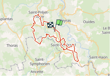
17,4 km | 24 km-effort
5h 8min
![](https://static1.geolcdn.com/siteimages/upload/files/16400158638029165_repeat_loop_refresh_sync_direction_icon.png)
Nein
![Tour Wandern Alleyras - vers Montrisol d'Allier - Photo](https://media.geolcdn.com/t/375/260/cccf6055-cbfb-4328-b6f3-4de34eb10b9b.jpg&format=jpg&maxdim=2)
![Wandern Wandern](https://static1.geolcdn.com/sitytour/trail-icons/101.png)
vers Montrisol d'Allier
Wandern
Medium
Alleyras,
Auvergne-Rhone-Alpen,
Haute-Loire,
France
![](/images/other/stat-length.png)
12,9 km | 18,4 km-effort
2h 37min
![](https://static1.geolcdn.com/siteimages/upload/files/16400158638029165_repeat_loop_refresh_sync_direction_icon.png)
Ja
![Tour Wandern Alleyras - Vallées 2 - Photo](https://media.geolcdn.com/t/375/260/8b8d2ca3-6474-43f7-b7d1-cb414f966ec9.jpg&format=jpg&maxdim=2)
![Wandern Wandern](https://static1.geolcdn.com/sitytour/trail-icons/101.png)
Vallées 2
Wandern
Einfach
Alleyras,
Auvergne-Rhone-Alpen,
Haute-Loire,
France
![](/images/other/stat-length.png)
5,3 km | 7,7 km-effort
1h 30min
![](https://static1.geolcdn.com/siteimages/upload/files/16400158638029165_repeat_loop_refresh_sync_direction_icon.png)
Ja
![Tour Wandern Alleyras - Alleyras - Photo](https://media.geolcdn.com/t/375/260/d7db957f-193c-44c9-b8fe-0dda88c88d23.jpg&format=jpg&maxdim=2)
![Wandern Wandern](https://static1.geolcdn.com/sitytour/trail-icons/101.png)
Alleyras
Wandern
Einfach
Alleyras,
Auvergne-Rhone-Alpen,
Haute-Loire,
France
![](/images/other/stat-length.png)
3,1 km | 4,8 km-effort
35min
![](https://static1.geolcdn.com/siteimages/upload/files/16400158638029165_repeat_loop_refresh_sync_direction_icon.png)
Nein
![Tour Zu Fuß Saint-Christophe-d'Allier - Les bords de l'Allier - Photo](https://media.geolcdn.com/t/375/260/ext.jpg?maxdim=2&url=https%3A%2F%2Fstatic1.geolcdn.com%2Fsiteimages%2Fupload%2Ffiles%2F1545311037marcheuse_200dpi.jpg)
![Zu Fuß Zu Fuß](https://static1.geolcdn.com/sitytour/trail-icons/100.png)
Les bords de l'Allier
Zu Fuß
Einfach
Saint-Christophe-d'Allier,
Auvergne-Rhone-Alpen,
Haute-Loire,
France
![](/images/other/stat-length.png)
9,8 km | 13,4 km-effort
3h 3min
![](https://static1.geolcdn.com/siteimages/upload/files/16400158638029165_repeat_loop_refresh_sync_direction_icon.png)
Ja
![Tour Mountainbike Alleyras - alleyras mazemblard ouides agrain 22012012 - Photo](https://media.geolcdn.com/t/375/260/ext.jpg?maxdim=2&url=https%3A%2F%2Fservices.sitytrail.com%2FGeolivesWS%2FDownloadMedia.ashx%3FTrailID%3D99078%26Media%3D20120122120315.jpg)
![Mountainbike Mountainbike](https://static1.geolcdn.com/sitytour/trail-icons/202.png)
alleyras mazemblard ouides agrain 22012012
Mountainbike
Schwierig
Alleyras,
Auvergne-Rhone-Alpen,
Haute-Loire,
France
![](/images/other/stat-length.png)
25 km | 37 km-effort
3h 32min
![](https://static1.geolcdn.com/siteimages/upload/files/16400158638029165_repeat_loop_refresh_sync_direction_icon.png)
Ja
![Tour Wandern Bel-Air-Val-d'Ance - chambon le chateau - Photo](https://media.geolcdn.com/t/375/260/ext.jpg?maxdim=2&url=https%3A%2F%2Fstatic1.geolcdn.com%2Fsiteimages%2Fupload%2Ffiles%2F1553511878bg_sport_marche.png)
![Wandern Wandern](https://static1.geolcdn.com/sitytour/trail-icons/101.png)
chambon le chateau
Wandern
Medium
Bel-Air-Val-d'Ance,
Okzitanien,
Lozère,
France
![](/images/other/stat-length.png)
8,7 km | 10,9 km-effort
2h 18min
![](https://static1.geolcdn.com/siteimages/upload/files/16400158638029165_repeat_loop_refresh_sync_direction_icon.png)
Ja
![Tour Mountainbike Saint-Christophe-d'Allier - Sodo fin rouluraid 2024 - Photo](https://media.geolcdn.com/t/375/260/ext.jpg?maxdim=2&url=https%3A%2F%2Fstatic1.geolcdn.com%2Fsiteimages%2Fupload%2Ffiles%2F1524743154velo.jpg)
![Mountainbike Mountainbike](https://static1.geolcdn.com/sitytour/trail-icons/202.png)
Sodo fin rouluraid 2024
Mountainbike
Einfach
Saint-Christophe-d'Allier,
Auvergne-Rhone-Alpen,
Haute-Loire,
France
![](/images/other/stat-length.png)
12,4 km | 16,2 km-effort
2h 4min
![](https://static1.geolcdn.com/siteimages/upload/files/16400158638029165_repeat_loop_refresh_sync_direction_icon.png)
Ja
![Tour Wandern Alleyras - bolena plus baume - Photo](https://media.geolcdn.com/t/375/260/d1cb8394-bcee-4a66-b8c8-c7364de4f23b.jpg&format=jpg&maxdim=2)
![Wandern Wandern](https://static1.geolcdn.com/sitytour/trail-icons/101.png)
bolena plus baume
Wandern
Schwierig
Alleyras,
Auvergne-Rhone-Alpen,
Haute-Loire,
France
![](/images/other/stat-length.png)
14,9 km | 21 km-effort
5h 8min
![](https://static1.geolcdn.com/siteimages/upload/files/16400158638029165_repeat_loop_refresh_sync_direction_icon.png)
Ja