![](/images/other/stat-length.png)
![Tour Andere Aktivitäten La Ferrière - Lac du Cul-des-prés - Photo](https://media.geolcdn.com/t/1900/400/ext.pjpeg?maxdim=2&url=https%3A%2F%2Fstatic1.geolcdn.com%2Fsiteimages%2Fupload%2Ffiles%2F1545311037marcheuse_200dpi.jpg)
Lac du Cul-des-prés
steve
Benutzer
![Länge](/images/other/stat-length.png)
![Maximale Höhe](https://static1.geolcdn.com/siteimages/upload/files/1508320355ic_sort_altitude_max_24dp.png)
![Positive Höhendifferenz](https://static1.geolcdn.com/siteimages/upload/files/1508320355ic_sort_den_pos_24dp.png)
![Km-Effort](/images/other/stat-length.png)
![Min. Höhe](https://static1.geolcdn.com/siteimages/upload/files/1508320355ic_sort_altitude_min_24dp.png)
![Negative Höhendifferenz](https://static1.geolcdn.com/siteimages/upload/files/1508320355ic_sort_den_neg_24dp.png)
![Boucle](https://static1.geolcdn.com/siteimages/upload/files/16400158638029165_repeat_loop_refresh_sync_direction_icon.png)
![Andere Aktivitäten](https://static1.geolcdn.com/sitytour/trail-icons/900.png)
--
Schwierigkeit : Unbekannt
![Scannen Sie diesen QR-Code, um die Tour in der SityTrail-Anwendung zu öffnen](https://capi.geolives.com/qq0zvz2zws4bq2lad0pu/sitytour/trails/24990/qr.png?size=200)
Kostenlosegpshiking-Anwendung
Über SityTrail
Tour Andere Aktivitäten von 12,6 km verfügbar auf Bern, Verwaltungskreis Berner Jura, La Ferrière. Diese Tour wird von steve vorgeschlagen.
Beschreibung
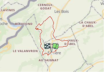
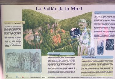
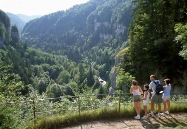
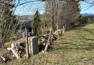
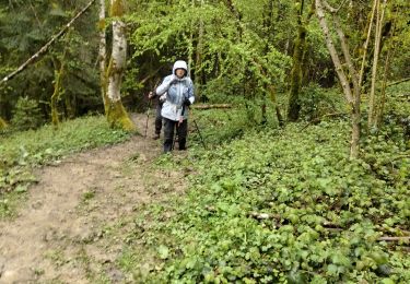
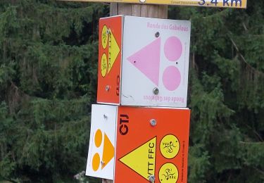
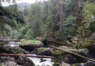
Départ de La Ferrière sur la place du village. Direction l''école puis descendre dans la combe. Suivre les losanges jaunes. Le canal est souvent à sec l''été. L''eau venant de la Ronde passant sous la ville de La Chaux-de-Fonds puis en partie de la STEP en passant par le Valanvron pour finir dans le lac du Cul-des-Prés et aussi en partie dans l''étang de Biaufond. Arrivé au lac, il faut remonter dans la forêt. La montée est assez rude. Près du golf des Bois, nous retournons sur la halte de La Large journée. Remontant sur l''hôtel-pension de La Chaux-d''Abel, nous suivons la route jusqu''au village.
Ort
Kommentare
Touren in der Umgebung
![Tour Wandern Charquemont - Échelles de la mort - Photo](https://media.geolcdn.com/t/375/260/7b9848bb-a43e-4c47-8544-5e7b63b496f6.jpg&format=jpg&maxdim=2)
![Wandern Wandern](https://static1.geolcdn.com/sitytour/trail-icons/101.png)
Wandern
![](/images/other/stat-length.png)
![](https://static1.geolcdn.com/siteimages/upload/files/16400158638029165_repeat_loop_refresh_sync_direction_icon.png)
![Tour Wandern Charquemont - Les Echelles de la Mort - Doubs - Photo](https://media.geolcdn.com/t/375/260/ext.jpg?maxdim=2&url=https%3A%2F%2Fservices.sitytrail.com%2FGeolivesWS%2FDownloadMedia.ashx%3FTrailID%3D108929%26Media%3D2620_1.jpg)
![Wandern Wandern](https://static1.geolcdn.com/sitytour/trail-icons/101.png)
Wandern
![](/images/other/stat-length.png)
![](https://static1.geolcdn.com/siteimages/upload/files/16400158638029165_repeat_loop_refresh_sync_direction_icon.png)
![Tour Zu Fuß Renan (BE) - Renan Le Plan-Pertuis - Photo](https://media.geolcdn.com/t/375/260/418efa7c-d347-4edd-a4f0-3cf84ea5789b.jpeg&format=jpg&maxdim=2)
![Zu Fuß Zu Fuß](https://static1.geolcdn.com/sitytour/trail-icons/100.png)
Zu Fuß
![](/images/other/stat-length.png)
![](https://static1.geolcdn.com/siteimages/upload/files/16400158638029165_repeat_loop_refresh_sync_direction_icon.png)
![Tour Wandern Fournet-Blancheroche - Combe de Biaufond - Photo](https://media.geolcdn.com/t/375/260/ext.jpg?maxdim=2&url=https%3A%2F%2Fstatic1.geolcdn.com%2Fsiteimages%2Fupload%2Ffiles%2F1553511878bg_sport_marche.png)
![Wandern Wandern](https://static1.geolcdn.com/sitytour/trail-icons/101.png)
Wandern
![](/images/other/stat-length.png)
![](https://static1.geolcdn.com/siteimages/upload/files/16400158638029165_repeat_loop_refresh_sync_direction_icon.png)
![Tour Wandern Charquemont - lçendre cha4quemond - Photo](https://media.geolcdn.com/t/375/260/d4b171d3-4707-4b81-9ad5-a84cf10f6378.jpg&format=jpg&maxdim=2)
![Wandern Wandern](https://static1.geolcdn.com/sitytour/trail-icons/101.png)
Wandern
![](/images/other/stat-length.png)
![](https://static1.geolcdn.com/siteimages/upload/files/16400158638029165_repeat_loop_refresh_sync_direction_icon.png)
![Tour Wandern Charquemont - LES ECHELLES DE LA MORT - Photo](https://media.geolcdn.com/t/375/260/eedace1f-3156-432d-a68f-d4e4629d6189.jpg&format=jpg&maxdim=2)
![Wandern Wandern](https://static1.geolcdn.com/sitytour/trail-icons/101.png)
Wandern
![](/images/other/stat-length.png)
![](https://static1.geolcdn.com/siteimages/upload/files/16400158638029165_repeat_loop_refresh_sync_direction_icon.png)
![Tour Wandern Charquemont - boucle autour des échelles de la mort - Photo](https://media.geolcdn.com/t/375/260/f6a45577-d0bb-4b93-af68-edc642da0084.jpg&format=jpg&maxdim=2)
![Wandern Wandern](https://static1.geolcdn.com/sitytour/trail-icons/101.png)
Wandern
![](/images/other/stat-length.png)
![](https://static1.geolcdn.com/siteimages/upload/files/16400158638029165_repeat_loop_refresh_sync_direction_icon.png)
![Tour Wandern Fournet-Blancheroche - Fournet Blancheroche Le Refrain (IBP87) 22 avril 2021 CAF - Photo](https://media.geolcdn.com/t/375/260/c01e38d9-a694-41fc-adc2-319ae93eb4b6.jpg&format=jpg&maxdim=2)
![Wandern Wandern](https://static1.geolcdn.com/sitytour/trail-icons/101.png)
Wandern
![](/images/other/stat-length.png)
![](https://static1.geolcdn.com/siteimages/upload/files/16400158638029165_repeat_loop_refresh_sync_direction_icon.png)
![Tour Wandern Fournet-Blancheroche - Barrage du Refrain (IBP 88) 01 avril 2021 reco Pierre R - Photo](https://media.geolcdn.com/t/375/260/266a57a6-9e26-42c4-a107-5fce4ac3d2b6.jpg&format=jpg&maxdim=2)
![Wandern Wandern](https://static1.geolcdn.com/sitytour/trail-icons/101.png)
Wandern
![](/images/other/stat-length.png)
![](https://static1.geolcdn.com/siteimages/upload/files/16400158638029165_repeat_loop_refresh_sync_direction_icon.png)