![](/images/other/stat-length.png)
![Tour Mountainbike Varces-Allières-et-Risset - tour du Cornafion par col de l'Arc et col Vert - Photo](https://media.geolcdn.com/t/1900/400/ed419b48-96d1-4afd-b336-4324cb35bedc.jpg&format=pjpeg&maxdim=2)
tour du Cornafion par col de l'Arc et col Vert
Yannick Pietruszewski
Benutzer
![Länge](/images/other/stat-length.png)
Länge
36 km
![Maximale Höhe](https://static1.geolcdn.com/siteimages/upload/files/1508320355ic_sort_altitude_max_24dp.png)
Maximale Höhe
1746 m
![Positive Höhendifferenz](https://static1.geolcdn.com/siteimages/upload/files/1508320355ic_sort_den_pos_24dp.png)
Positive Höhendifferenz
1890 m
![Km-Effort](/images/other/stat-length.png)
Km-Effort
61 km
![Min. Höhe](https://static1.geolcdn.com/siteimages/upload/files/1508320355ic_sort_altitude_min_24dp.png)
Min. Höhe
276 m
![Negative Höhendifferenz](https://static1.geolcdn.com/siteimages/upload/files/1508320355ic_sort_den_neg_24dp.png)
Negative Höhendifferenz
1887 m
![Boucle](https://static1.geolcdn.com/siteimages/upload/files/16400158638029165_repeat_loop_refresh_sync_direction_icon.png)
Boucle
Ja
Erstellungsdatum :
2020-07-30 07:02:54.753
Letzte Änderung :
2020-07-31 16:29:35.83
![Mountainbike](https://static1.geolcdn.com/sitytour/trail-icons/202.png)
6h12
Schwierigkeit : Schwierig
![Scannen Sie diesen QR-Code, um die Tour in der SityTrail-Anwendung zu öffnen](https://capi.geolives.com/qq0zvz2zws4bq2lad0pu/sitytour/trails/2495774/qr.png?size=200)
Kostenlosegpshiking-Anwendung
Über SityTrail
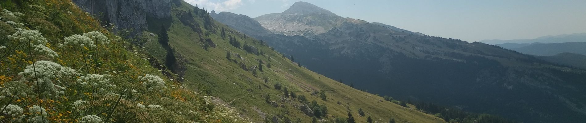
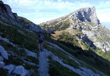
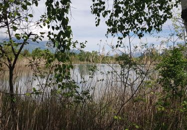
Tour Mountainbike von 36 km verfügbar auf Auvergne-Rhone-Alpen, Isère, Varces-Allières-et-Risset. Diese Tour wird von Yannick Pietruszewski vorgeschlagen.
Beschreibung
canicule en vallée, bon en altitude, sentiers bien sec comme on aime, pas mal de randonneurs près des cols. Attention, parcours avec beaucoup de portage et poussage
Ort
Land:
France
Region :
Auvergne-Rhone-Alpen
Abteilung/Provinz :
Isère
Kommune :
Varces-Allières-et-Risset
Standort:
Unknown
Gehen Sie:(Dec)
Gehen Sie:(UTM)
710758 ; 4996100 (31T) N.
Kommentare
Touren in der Umgebung
![Tour Wandern Claix - caba - Photo](https://media.geolcdn.com/t/375/260/ext.jpg?maxdim=2&url=https%3A%2F%2Fstatic1.geolcdn.com%2Fsiteimages%2Fupload%2Ffiles%2F1553511878bg_sport_marche.png)
![Wandern Wandern](https://static1.geolcdn.com/sitytour/trail-icons/101.png)
caba
Wandern
Sehr leicht
(1)
Claix,
Auvergne-Rhone-Alpen,
Isère,
France
![](/images/other/stat-length.png)
8,7 km | 16,6 km-effort
5h 2min
![](https://static1.geolcdn.com/siteimages/upload/files/16400158638029165_repeat_loop_refresh_sync_direction_icon.png)
Ja
![Tour Wandern Claix - Le balcon du pic Saint Michel Par la grotte des pouliches - Photo](https://media.geolcdn.com/t/375/260/26eba98c-7ea6-42d6-9ec9-9d07c3062889.jpg&format=jpg&maxdim=2)
![Wandern Wandern](https://static1.geolcdn.com/sitytour/trail-icons/101.png)
Le balcon du pic Saint Michel Par la grotte des pouliches
Wandern
Schwierig
Claix,
Auvergne-Rhone-Alpen,
Isère,
France
![](/images/other/stat-length.png)
14,5 km | 31 km-effort
8h 0min
![](https://static1.geolcdn.com/siteimages/upload/files/16400158638029165_repeat_loop_refresh_sync_direction_icon.png)
Ja
![Tour Nordic Walking Claix - Le Peuil 5 Km - Photo](https://media.geolcdn.com/t/375/260/ext.jpg?maxdim=2&url=https%3A%2F%2Fstatic1.geolcdn.com%2Fsiteimages%2Fupload%2Ffiles%2F1545311037marcheuse_200dpi.jpg)
![Nordic Walking Nordic Walking](https://static1.geolcdn.com/sitytour/trail-icons/102.png)
Le Peuil 5 Km
Nordic Walking
Einfach
(1)
Claix,
Auvergne-Rhone-Alpen,
Isère,
France
![](/images/other/stat-length.png)
5,3 km | 7,1 km-effort
1h 28min
![](https://static1.geolcdn.com/siteimages/upload/files/16400158638029165_repeat_loop_refresh_sync_direction_icon.png)
Ja
![Tour Wandern Champ-sur-Drac - 38 Couvent St Michel Champ / drac - Photo](https://media.geolcdn.com/t/375/260/2541c209-e2b9-4fc5-ac0c-29659bf67ee5.jpg&format=jpg&maxdim=2)
![Wandern Wandern](https://static1.geolcdn.com/sitytour/trail-icons/101.png)
38 Couvent St Michel Champ / drac
Wandern
Medium
Champ-sur-Drac,
Auvergne-Rhone-Alpen,
Isère,
France
![](/images/other/stat-length.png)
9,4 km | 19,7 km-effort
3h 0min
![](https://static1.geolcdn.com/siteimages/upload/files/16400158638029165_repeat_loop_refresh_sync_direction_icon.png)
Ja
![Tour Wandern Varces-Allières-et-Risset - Les Etangs de Reymure réaménagés en 2023. - Photo](https://media.geolcdn.com/t/375/260/a9036917-cc32-4324-8d0a-4d872f501612.jpg&format=jpg&maxdim=2)
![Wandern Wandern](https://static1.geolcdn.com/sitytour/trail-icons/101.png)
Les Etangs de Reymure réaménagés en 2023.
Wandern
Medium
Varces-Allières-et-Risset,
Auvergne-Rhone-Alpen,
Isère,
France
![](/images/other/stat-length.png)
7,9 km | 8,6 km-effort
2h 35min
![](https://static1.geolcdn.com/siteimages/upload/files/16400158638029165_repeat_loop_refresh_sync_direction_icon.png)
Ja
![Tour Wandern Vif - la ferme oriol en circuit - Photo](https://media.geolcdn.com/t/375/260/40456475-f1df-45a6-819a-93e9ddb16412.jpg&format=jpg&maxdim=2)
![Wandern Wandern](https://static1.geolcdn.com/sitytour/trail-icons/101.png)
la ferme oriol en circuit
Wandern
Sehr schwierig
Vif,
Auvergne-Rhone-Alpen,
Isère,
France
![](/images/other/stat-length.png)
13,7 km | 24 km-effort
3h 15min
![](https://static1.geolcdn.com/siteimages/upload/files/16400158638029165_repeat_loop_refresh_sync_direction_icon.png)
Ja
![Tour Wandern Claix - La Tourbière du Peuil - Photo](https://media.geolcdn.com/t/375/260/12a96e27-edba-4d2b-ae09-b32ddf1adbb4.jpg&format=jpg&maxdim=2)
![Wandern Wandern](https://static1.geolcdn.com/sitytour/trail-icons/101.png)
La Tourbière du Peuil
Wandern
Einfach
Claix,
Auvergne-Rhone-Alpen,
Isère,
France
![](/images/other/stat-length.png)
4 km | 5,4 km-effort
1h 13min
![](https://static1.geolcdn.com/siteimages/upload/files/16400158638029165_repeat_loop_refresh_sync_direction_icon.png)
Ja
![Tour Nordic Walking Vif - Les Etangs de la Plaine de Reymure - Photo](https://media.geolcdn.com/t/375/260/1d6be850-f5d4-4e8e-a42b-a881c0492ad2.jpg&format=jpg&maxdim=2)
![Nordic Walking Nordic Walking](https://static1.geolcdn.com/sitytour/trail-icons/102.png)
Les Etangs de la Plaine de Reymure
Nordic Walking
Einfach
Vif,
Auvergne-Rhone-Alpen,
Isère,
France
![](/images/other/stat-length.png)
9,4 km | 10,3 km-effort
2h 0min
![](https://static1.geolcdn.com/siteimages/upload/files/16400158638029165_repeat_loop_refresh_sync_direction_icon.png)
Ja
![Tour Wandern Claix - Traversée Le Peuil - Le Pré du Four - Retour par la cabane de La Robine - Photo](https://media.geolcdn.com/t/375/260/910cc0e9-4f5c-4c48-a8a7-87d4365e7188.jpg&format=jpg&maxdim=2)
![Wandern Wandern](https://static1.geolcdn.com/sitytour/trail-icons/101.png)
Traversée Le Peuil - Le Pré du Four - Retour par la cabane de La Robine
Wandern
Medium
Claix,
Auvergne-Rhone-Alpen,
Isère,
France
![](/images/other/stat-length.png)
13,4 km | 23 km-effort
4h 1min
![](https://static1.geolcdn.com/siteimages/upload/files/16400158638029165_repeat_loop_refresh_sync_direction_icon.png)
Ja