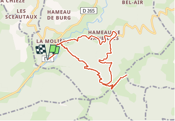
![](/images/other/stat-length.png)
![Tour Wandern Saint-Vincent-de-Durfort - Randonnée nocturne aux Croix de Gruas - Photo](https://media.geolcdn.com/t/1900/400/9f5fe7bb-9305-41c6-ab29-b616b2a46650.jpg&format=pjpeg&maxdim=2)
Randonnée nocturne aux Croix de Gruas
jome63
Benutzer
![Länge](/images/other/stat-length.png)
![Maximale Höhe](https://static1.geolcdn.com/siteimages/upload/files/1508320355ic_sort_altitude_max_24dp.png)
![Positive Höhendifferenz](https://static1.geolcdn.com/siteimages/upload/files/1508320355ic_sort_den_pos_24dp.png)
![Km-Effort](/images/other/stat-length.png)
![Min. Höhe](https://static1.geolcdn.com/siteimages/upload/files/1508320355ic_sort_altitude_min_24dp.png)
![Negative Höhendifferenz](https://static1.geolcdn.com/siteimages/upload/files/1508320355ic_sort_den_neg_24dp.png)
![Boucle](https://static1.geolcdn.com/siteimages/upload/files/16400158638029165_repeat_loop_refresh_sync_direction_icon.png)
![Wandern](https://static1.geolcdn.com/sitytour/trail-icons/101.png)
3h17
Schwierigkeit : Schwierig
![Scannen Sie diesen QR-Code, um die Tour in der SityTrail-Anwendung zu öffnen](https://capi.geolives.com/qq0zvz2zws4bq2lad0pu/sitytour/trails/2495009/qr.png?size=200)
Kostenlosegpshiking-Anwendung
Über SityTrail
Tour Wandern von 10,3 km verfügbar auf Auvergne-Rhone-Alpen, Ardèche, Saint-Vincent-de-Durfort. Diese Tour wird von jome63 vorgeschlagen.
Beschreibung
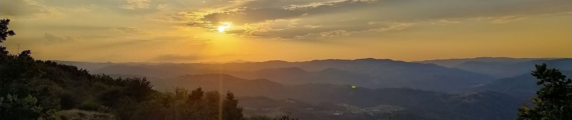
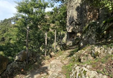
Une randonnée nocturne proposée par l'équipe du camping Coeur d'Ardèche : Le départ se situe au camping, après avoir vérifié que chacun a bien une lampe pour le retour de nuit. La montée demande un effort physique, mais elle peut se faire avec un rythme plus lent. Arrivée aux Croix de Gruas, nous avons été jusqu'à une source d'eau bien fraîche. Le point de vue depuis les Croix de Gruas permet de voir plusieurs départements, et un sublime coucher de soleil sur l'Ardèche ! Le retour se faisant de nuit, nous avons emprunté la route départementale, où nous n'avons croisé aucune voiture.
www.campingcoeurardeche.com
Ort
Kommentare
Touren in der Umgebung
![Tour Wandern Lyas - 07 privas Livier zel - Photo](https://media.geolcdn.com/t/375/260/8d24354e-b88b-4db6-bb2a-e550ffe8d9ce.jpg&format=jpg&maxdim=2)
![Wandern Wandern](https://static1.geolcdn.com/sitytour/trail-icons/101.png)
Wandern
![](/images/other/stat-length.png)
![](https://static1.geolcdn.com/siteimages/upload/files/16400158638029165_repeat_loop_refresh_sync_direction_icon.png)
![Tour Wandern Pranles - 07 chirouze prandes - Photo](https://media.geolcdn.com/t/375/260/410f3c87-d596-4d9a-9969-d749769d3ba9.jpg&format=jpg&maxdim=2)
![Wandern Wandern](https://static1.geolcdn.com/sitytour/trail-icons/101.png)
Wandern
![](/images/other/stat-length.png)
![](https://static1.geolcdn.com/siteimages/upload/files/16400158638029165_repeat_loop_refresh_sync_direction_icon.png)
![Tour Wandern Les Ollières-sur-Eyrieux - 07 ollieres sur eyrieux Gruas - Photo](https://media.geolcdn.com/t/375/260/9ffda187-d312-43bf-86a6-ea773d0d4ffe.jpg&format=jpg&maxdim=2)
![Wandern Wandern](https://static1.geolcdn.com/sitytour/trail-icons/101.png)
Wandern
![](/images/other/stat-length.png)
![](https://static1.geolcdn.com/siteimages/upload/files/16400158638029165_repeat_loop_refresh_sync_direction_icon.png)
![Tour Wandern Coux - Jaubernie - Photo](https://media.geolcdn.com/t/375/260/ext.jpg?maxdim=2&url=https%3A%2F%2Fstatic1.geolcdn.com%2Fsiteimages%2Fupload%2Ffiles%2F1553511878bg_sport_marche.png)
![Wandern Wandern](https://static1.geolcdn.com/sitytour/trail-icons/101.png)
Wandern
![](/images/other/stat-length.png)
![](https://static1.geolcdn.com/siteimages/upload/files/16400158638029165_repeat_loop_refresh_sync_direction_icon.png)
![Tour sport Pranles - Volcan des Chirouses - Azur - Photo](https://media.geolcdn.com/t/375/260/e60b1bfd-acf1-4756-a1be-a13c787b6ba0.jpg&format=jpg&maxdim=2)
sport
![](/images/other/stat-length.png)
![](https://static1.geolcdn.com/siteimages/upload/files/16400158638029165_repeat_loop_refresh_sync_direction_icon.png)
![Tour Rennrad Saint-Fortunat-sur-Eyrieux - 07 st Fortunat st agreve vv - Photo](https://media.geolcdn.com/t/375/260/8f83dac9-764a-4d77-bc61-77b94ef715b6.jpg&format=jpg&maxdim=2)
![Rennrad Rennrad](https://static1.geolcdn.com/sitytour/trail-icons/201.png)
Rennrad
![](/images/other/stat-length.png)
![](https://static1.geolcdn.com/siteimages/upload/files/16400158638029165_repeat_loop_refresh_sync_direction_icon.png)
![Tour Wandern Flaviac - Flaviac Serre de l'Eglise 15km - Photo](https://media.geolcdn.com/t/375/260/6203886c-16c3-47c9-ace2-85f55b06e3cd.jpg&format=jpg&maxdim=2)
![Wandern Wandern](https://static1.geolcdn.com/sitytour/trail-icons/101.png)
Wandern
![](/images/other/stat-length.png)
![](https://static1.geolcdn.com/siteimages/upload/files/16400158638029165_repeat_loop_refresh_sync_direction_icon.png)
![Tour Wandern Pranles - Volcan de Chirouse 14 km. - Photo](https://media.geolcdn.com/t/375/260/aa0a374f-85d6-48cb-ab24-139c041e256a.jpeg&format=jpg&maxdim=2)
![Wandern Wandern](https://static1.geolcdn.com/sitytour/trail-icons/101.png)
Wandern
![](/images/other/stat-length.png)
![](https://static1.geolcdn.com/siteimages/upload/files/16400158638029165_repeat_loop_refresh_sync_direction_icon.png)
![Tour Wandern Flaviac - 2023-05-28_15h23m00_t268154536_nb flaviac - Photo](https://media.geolcdn.com/t/375/260/6c6fdff5-3cac-4ee3-b783-0d4bea6142ec.jpg&format=jpg&maxdim=2)
![Wandern Wandern](https://static1.geolcdn.com/sitytour/trail-icons/101.png)
Wandern
![](/images/other/stat-length.png)
![](https://static1.geolcdn.com/siteimages/upload/files/16400158638029165_repeat_loop_refresh_sync_direction_icon.png)