![](/images/other/stat-length.png)
![Tour Mountainbike Gedinne - Gedinne - Croix Scaille - Photo](https://media.geolcdn.com/t/1900/400/8f0394ef-5175-45b7-b0d6-7e7f7b1ca866.jpg&format=pjpeg&maxdim=2)
Gedinne - Croix Scaille
beautrix
Benutzer
![Länge](/images/other/stat-length.png)
Länge
32 km
![Maximale Höhe](https://static1.geolcdn.com/siteimages/upload/files/1508320355ic_sort_altitude_max_24dp.png)
Maximale Höhe
512 m
![Positive Höhendifferenz](https://static1.geolcdn.com/siteimages/upload/files/1508320355ic_sort_den_pos_24dp.png)
Positive Höhendifferenz
610 m
![Km-Effort](/images/other/stat-length.png)
Km-Effort
40 km
![Min. Höhe](https://static1.geolcdn.com/siteimages/upload/files/1508320355ic_sort_altitude_min_24dp.png)
Min. Höhe
294 m
![Negative Höhendifferenz](https://static1.geolcdn.com/siteimages/upload/files/1508320355ic_sort_den_neg_24dp.png)
Negative Höhendifferenz
600 m
![Boucle](https://static1.geolcdn.com/siteimages/upload/files/16400158638029165_repeat_loop_refresh_sync_direction_icon.png)
Boucle
Ja
Erstellungsdatum :
2020-07-25 08:18:56.804
Letzte Änderung :
2020-07-26 09:34:48.792
![Mountainbike](https://static1.geolcdn.com/sitytour/trail-icons/202.png)
2h03
Schwierigkeit : Medium
![Scannen Sie diesen QR-Code, um die Tour in der SityTrail-Anwendung zu öffnen](https://capi.geolives.com/qq0zvz2zws4bq2lad0pu/sitytour/trails/2489174/qr.png?size=200)
Kostenlosegpshiking-Anwendung
Über SityTrail
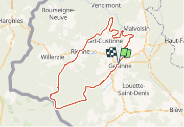
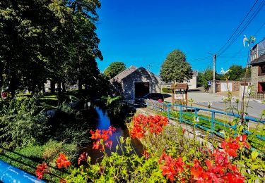
Tour Mountainbike von 32 km verfügbar auf Wallonien, Namur, Gedinne. Diese Tour wird von beautrix vorgeschlagen.
Beschreibung
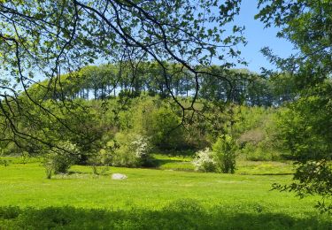
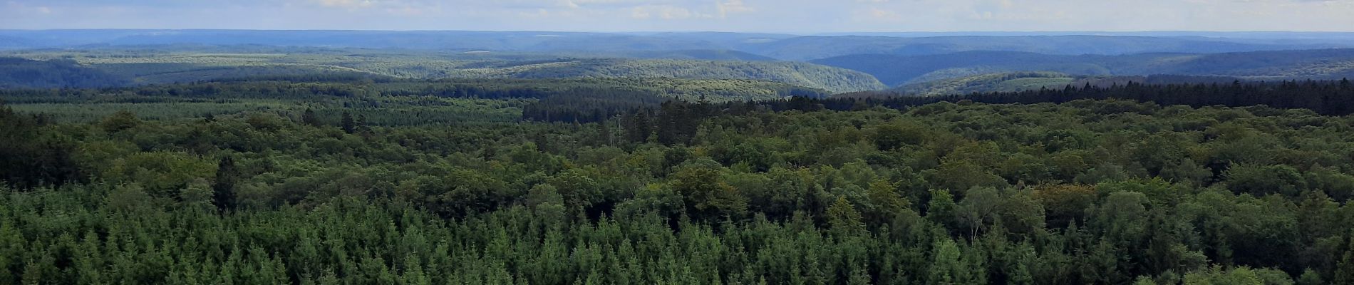
Un beau parcours forestier, pour atteindre la Croix scaille, point culminant de la province de Namur.
Chemins faciles, pas trop techniques... De longues et belles descentes.
Ort
Land:
Belgium
Region :
Wallonien
Abteilung/Provinz :
Namur
Kommune :
Gedinne
Standort:
Gedinne
Gehen Sie:(Dec)
Gehen Sie:(UTM)
638882 ; 5538293 (31U) N.
Kommentare
Touren in der Umgebung
![Tour Wandern Gedinne - RB-Na-08 Dans la vallée de la Houille - Photo](https://media.geolcdn.com/t/375/260/ext.jpg?maxdim=2&url=https%3A%2F%2Fservices.sitytrail.com%2FGeolivesWS%2FDownloadMedia.ashx%3FTrailID%3D179634%26Media%3D50c146e4-51ae-4441-b546-c84e45c04bf9.jpg)
![Wandern Wandern](https://static1.geolcdn.com/sitytour/trail-icons/101.png)
RB-Na-08 Dans la vallée de la Houille
Wandern
Medium
(5)
Gedinne,
Wallonien,
Namur,
Belgium
![](/images/other/stat-length.png)
22 km | 28 km-effort
6h 0min
![](https://static1.geolcdn.com/siteimages/upload/files/16400158638029165_repeat_loop_refresh_sync_direction_icon.png)
Ja
![Tour Wandern Gedinne - La vallée de la Houille - Rienne - Photo](https://media.geolcdn.com/t/375/260/ext.jpg?maxdim=2&url=https%3A%2F%2Fstatic1.geolcdn.com%2Fsiteimages%2Fupload%2Ffiles%2F1553511878bg_sport_marche.png)
![Wandern Wandern](https://static1.geolcdn.com/sitytour/trail-icons/101.png)
La vallée de la Houille - Rienne
Wandern
Medium
(1)
Gedinne,
Wallonien,
Namur,
Belgium
![](/images/other/stat-length.png)
22 km | 28 km-effort
5h 30min
![](https://static1.geolcdn.com/siteimages/upload/files/16400158638029165_repeat_loop_refresh_sync_direction_icon.png)
Ja
![Tour Wandern Gedinne - Balade à Patignies - Gedinne - Photo](https://media.geolcdn.com/t/375/260/79e5cc1f-1a8a-44ba-9eaa-8936fd24b6f1.jpg&format=jpg&maxdim=2)
![Wandern Wandern](https://static1.geolcdn.com/sitytour/trail-icons/101.png)
Balade à Patignies - Gedinne
Wandern
Schwierig
Gedinne,
Wallonien,
Namur,
Belgium
![](/images/other/stat-length.png)
9,9 km | 12,7 km-effort
2h 52min
![](https://static1.geolcdn.com/siteimages/upload/files/16400158638029165_repeat_loop_refresh_sync_direction_icon.png)
Ja
![Tour Wandern Gedinne - Marche Adeps à Gedinne - Photo](https://media.geolcdn.com/t/375/260/b2e3f402-523c-4b23-a693-153835da4cba.jpeg&format=jpg&maxdim=2)
![Wandern Wandern](https://static1.geolcdn.com/sitytour/trail-icons/101.png)
Marche Adeps à Gedinne
Wandern
Schwierig
Gedinne,
Wallonien,
Namur,
Belgium
![](/images/other/stat-length.png)
10,3 km | 13,2 km-effort
2h 59min
![](https://static1.geolcdn.com/siteimages/upload/files/16400158638029165_repeat_loop_refresh_sync_direction_icon.png)
Ja
![Tour Wandern Gedinne - Balade à Gedinne - Photo](https://media.geolcdn.com/t/375/260/92091b90-2951-4f34-a96b-1298e851235d.jpg&format=jpg&maxdim=2)
![Wandern Wandern](https://static1.geolcdn.com/sitytour/trail-icons/101.png)
Balade à Gedinne
Wandern
Schwierig
Gedinne,
Wallonien,
Namur,
Belgium
![](/images/other/stat-length.png)
12,2 km | 15,5 km-effort
3h 31min
![](https://static1.geolcdn.com/siteimages/upload/files/16400158638029165_repeat_loop_refresh_sync_direction_icon.png)
Ja
![Tour Wandern Gedinne - Balade de Bourseigne-Vieille à Vencimont - Photo](https://media.geolcdn.com/t/375/260/25a96cf8-0350-40e1-8c90-b4807b7178ca.jpeg&format=jpg&maxdim=2)
![Wandern Wandern](https://static1.geolcdn.com/sitytour/trail-icons/101.png)
Balade de Bourseigne-Vieille à Vencimont
Wandern
Schwierig
Gedinne,
Wallonien,
Namur,
Belgium
![](/images/other/stat-length.png)
12,1 km | 16 km-effort
3h 38min
![](https://static1.geolcdn.com/siteimages/upload/files/16400158638029165_repeat_loop_refresh_sync_direction_icon.png)
Ja
![Tour Wandern Gedinne - Balade à Malvoisin - Gedinne - Photo](https://media.geolcdn.com/t/375/260/d0ef5110-1a6d-4a12-ba4f-4365dc035d50.jpeg&format=jpg&maxdim=2)
![Wandern Wandern](https://static1.geolcdn.com/sitytour/trail-icons/101.png)
Balade à Malvoisin - Gedinne
Wandern
Schwierig
Gedinne,
Wallonien,
Namur,
Belgium
![](/images/other/stat-length.png)
9,2 km | 12,1 km-effort
2h 44min
![](https://static1.geolcdn.com/siteimages/upload/files/16400158638029165_repeat_loop_refresh_sync_direction_icon.png)
Ja
![Tour Zu Fuß Gedinne - La Croix du Garde 05 - Photo](https://media.geolcdn.com/t/375/260/ext.jpg?maxdim=2&url=https%3A%2F%2Fpivotmedia.tourismewallonie.be%2FOTH-A0-006F-0SD2%2FOTH-A0-006F-0SD2.jpg)
![Zu Fuß Zu Fuß](https://static1.geolcdn.com/sitytour/trail-icons/100.png)
La Croix du Garde 05
Zu Fuß
Einfach
Gedinne,
Wallonien,
Namur,
Belgium
![](/images/other/stat-length.png)
9,7 km | 11,9 km-effort
2h 42min
![](https://static1.geolcdn.com/siteimages/upload/files/16400158638029165_repeat_loop_refresh_sync_direction_icon.png)
Ja
![Tour Zu Fuß Gedinne - Chersi 06 - Photo](https://media.geolcdn.com/t/375/260/ext.jpg?maxdim=2&url=https%3A%2F%2Fpivotmedia.tourismewallonie.be%2FOTH-A0-006F-1O8S%2FOTH-A0-006F-1O8S.jpg)
![Zu Fuß Zu Fuß](https://static1.geolcdn.com/sitytour/trail-icons/100.png)