![](/images/other/stat-length.png)
![Tour Wandern Borce - 64 Lac d' Estaens-chemin des échelles - Photo](https://media.geolcdn.com/t/1900/400/ext.pjpeg?maxdim=2&url=https%3A%2F%2Fstatic1.geolcdn.com%2Fsiteimages%2Fupload%2Ffiles%2F1553511878bg_sport_marche.png)
64 Lac d' Estaens-chemin des échelles
Maryma
Benutzer
![Länge](/images/other/stat-length.png)
![Maximale Höhe](https://static1.geolcdn.com/siteimages/upload/files/1508320355ic_sort_altitude_max_24dp.png)
![Positive Höhendifferenz](https://static1.geolcdn.com/siteimages/upload/files/1508320355ic_sort_den_pos_24dp.png)
![Km-Effort](/images/other/stat-length.png)
![Min. Höhe](https://static1.geolcdn.com/siteimages/upload/files/1508320355ic_sort_altitude_min_24dp.png)
![Negative Höhendifferenz](https://static1.geolcdn.com/siteimages/upload/files/1508320355ic_sort_den_neg_24dp.png)
![Boucle](https://static1.geolcdn.com/siteimages/upload/files/16400158638029165_repeat_loop_refresh_sync_direction_icon.png)
![Wandern](https://static1.geolcdn.com/sitytour/trail-icons/101.png)
4h03
Schwierigkeit : Medium
![Scannen Sie diesen QR-Code, um die Tour in der SityTrail-Anwendung zu öffnen](https://capi.geolives.com/qq0zvz2zws4bq2lad0pu/sitytour/trails/2487885/qr.png?size=200)
Kostenlosegpshiking-Anwendung
Über SityTrail
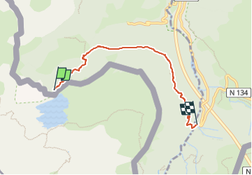
Tour Wandern von 5,3 km verfügbar auf Neu-Aquitanien, Pyrenäen-Atlantik, Borce. Diese Tour wird von Maryma vorgeschlagen.
Beschreibung
la rando effectuée est en fait une boucle. Le départ est le point d'arrivée. Après la montée en lacet, je suis partie vers Sansanet juste avant la cabane d'Escouret- puis la borne frontalière pour aller jusqu'au lac d'Estaens. Là je l'ai contourné par la droite (Est) jusqu'à trouver une sente qui descende par une cheminée rejoindre le chemin tracé. Attention, à la vue vertigineuse et à l'échelle qui peut être glissante en fonction du temps.
Une variété de paysages, des troupeaux au bord du lac, un côté plus sauvage quand on revient côté français et la cabane Escouret où l'on peut acheter du fromage de brebis, excellent et très bon marché!
Au total 4 heures de marche, pour une bonne dizaine de kilomètres et 600m D
Ort
Kommentare
Touren in der Umgebung
![Tour Zu Fuß Urdos - Sentier de Peyranère au Refuge de Larry PNP - Photo](https://media.geolcdn.com/t/375/260/12d86d0c-9ae8-4a0a-b713-61ee3738bf3b.jpeg&format=jpg&maxdim=2)
![Zu Fuß Zu Fuß](https://static1.geolcdn.com/sitytour/trail-icons/100.png)
Zu Fuß
![](/images/other/stat-length.png)
![](https://static1.geolcdn.com/siteimages/upload/files/16400158638029165_repeat_loop_refresh_sync_direction_icon.png)
![Tour Zu Fuß Urdos - Sentier du Plateau de la Gentiane PNP - Photo](https://media.geolcdn.com/t/375/260/12d86d0c-9ae8-4a0a-b713-61ee3738bf3b.jpeg&format=jpg&maxdim=2)
![Zu Fuß Zu Fuß](https://static1.geolcdn.com/sitytour/trail-icons/100.png)
Zu Fuß
![](/images/other/stat-length.png)
![](https://static1.geolcdn.com/siteimages/upload/files/16400158638029165_repeat_loop_refresh_sync_direction_icon.png)
![Tour Zu Fuß Urdos - Sentier du Lac d'Estaëns PNP - Photo](https://media.geolcdn.com/t/375/260/f2b54571-15e4-4669-844e-6d4a7160a93e.jpeg&format=jpg&maxdim=2)
![Zu Fuß Zu Fuß](https://static1.geolcdn.com/sitytour/trail-icons/100.png)
Zu Fuß
![](/images/other/stat-length.png)
![](https://static1.geolcdn.com/siteimages/upload/files/16400158638029165_repeat_loop_refresh_sync_direction_icon.png)
![Tour Wandern Borce - Boucle Lescun 4J - E4 - Photo](https://media.geolcdn.com/t/375/260/ext.jpg?maxdim=2&url=https%3A%2F%2Fstatic1.geolcdn.com%2Fsiteimages%2Fupload%2Ffiles%2F1553511878bg_sport_marche.png)
![Wandern Wandern](https://static1.geolcdn.com/sitytour/trail-icons/101.png)
Wandern
![](/images/other/stat-length.png)
![](https://static1.geolcdn.com/siteimages/upload/files/16400158638029165_repeat_loop_refresh_sync_direction_icon.png)
![Tour Wandern Borce - hrp Arlet to candanchu - Photo](https://media.geolcdn.com/t/375/260/ext.jpg?maxdim=2&url=https%3A%2F%2Fstatic1.geolcdn.com%2Fsiteimages%2Fupload%2Ffiles%2F1553511878bg_sport_marche.png)
![Wandern Wandern](https://static1.geolcdn.com/sitytour/trail-icons/101.png)
Wandern
![](/images/other/stat-length.png)
![](https://static1.geolcdn.com/siteimages/upload/files/16400158638029165_repeat_loop_refresh_sync_direction_icon.png)
![Tour Wandern Borce - Chemin de l'escalé - Photo](https://media.geolcdn.com/t/375/260/a66f4049-6310-4965-a5bd-700ca57594e4.jpg&format=jpg&maxdim=2)
![Wandern Wandern](https://static1.geolcdn.com/sitytour/trail-icons/101.png)
Wandern
![](/images/other/stat-length.png)
![](https://static1.geolcdn.com/siteimages/upload/files/16400158638029165_repeat_loop_refresh_sync_direction_icon.png)
![Tour Wandern Borce - Lac d'Estaens - Photo](https://media.geolcdn.com/t/375/260/1c0d5bd9-b4bf-4d4c-82d2-78a185a6a0dd.jpg&format=jpg&maxdim=2)
![Wandern Wandern](https://static1.geolcdn.com/sitytour/trail-icons/101.png)
Wandern
![](/images/other/stat-length.png)
![](https://static1.geolcdn.com/siteimages/upload/files/16400158638029165_repeat_loop_refresh_sync_direction_icon.png)
![Tour Wandern Urdos - Plateau de la gentiane - Photo](https://media.geolcdn.com/t/375/260/b1985722-4b53-4d00-9ae9-e27a98bdc95b.jpg&format=jpg&maxdim=2)
![Wandern Wandern](https://static1.geolcdn.com/sitytour/trail-icons/101.png)
Wandern
![](/images/other/stat-length.png)
![](https://static1.geolcdn.com/siteimages/upload/files/16400158638029165_repeat_loop_refresh_sync_direction_icon.png)
![Tour Wandern Urdos - Lac d'Estaens et environs - Photo](https://media.geolcdn.com/t/375/260/795b0e28-1fa9-4eb7-baf6-c4a84979127a.jpg&format=jpg&maxdim=2)
![Wandern Wandern](https://static1.geolcdn.com/sitytour/trail-icons/101.png)
Wandern
![](/images/other/stat-length.png)
![](https://static1.geolcdn.com/siteimages/upload/files/16400158638029165_repeat_loop_refresh_sync_direction_icon.png)