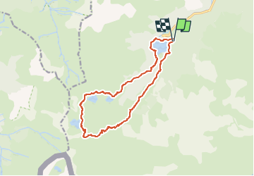
![](/images/other/stat-length.png)
![Tour Zu Fuß Laruns - 64 Lacs d'Ayous - Photo](https://media.geolcdn.com/t/1900/400/ext.pjpeg?maxdim=2&url=https%3A%2F%2Fstatic1.geolcdn.com%2Fsiteimages%2Fupload%2Ffiles%2F1545311037marcheuse_200dpi.jpg)
64 Lacs d'Ayous
Maryma
Benutzer
![Länge](/images/other/stat-length.png)
![Maximale Höhe](https://static1.geolcdn.com/siteimages/upload/files/1508320355ic_sort_altitude_max_24dp.png)
![Positive Höhendifferenz](https://static1.geolcdn.com/siteimages/upload/files/1508320355ic_sort_den_pos_24dp.png)
![Km-Effort](/images/other/stat-length.png)
![Min. Höhe](https://static1.geolcdn.com/siteimages/upload/files/1508320355ic_sort_altitude_min_24dp.png)
![Negative Höhendifferenz](https://static1.geolcdn.com/siteimages/upload/files/1508320355ic_sort_den_neg_24dp.png)
![Boucle](https://static1.geolcdn.com/siteimages/upload/files/16400158638029165_repeat_loop_refresh_sync_direction_icon.png)
![Zu Fuß](https://static1.geolcdn.com/sitytour/trail-icons/100.png)
--
Schwierigkeit : Medium
![Scannen Sie diesen QR-Code, um die Tour in der SityTrail-Anwendung zu öffnen](https://capi.geolives.com/qq0zvz2zws4bq2lad0pu/sitytour/trails/2487859/qr.png?size=200)
Kostenlosegpshiking-Anwendung
Über SityTrail
Tour Zu Fuß von 15 km verfügbar auf Neu-Aquitanien, Pyrenäen-Atlantik, Laruns. Diese Tour wird von Maryma vorgeschlagen.
Beschreibung
Pas de difficulté particulière. Le chemin à la sortie du lac Bious Artigues monte bien ; intéressant car chemin peu fréquenté et à l'ombre. Bien suivre la carte.
Un chapelet de lacs qui s'enchaînent. Magnifiés par la présence de troupeaux de chevaux et vaches.
Bivouac autour du lac Gentau ; baignades également à Gentau et Bersau. Ne suis pas sûre que cela soit bon pour l'écosystème. Nous apportons nos huiles solaires et bactéries dans un milieu fermé. A vous de voir. Retour au pied du pic du midi d'Ossau. Il fera l'objet d'une prochaine randonnée . Au lac Bious Artigues, canoé et bar.
Ort
Kommentare
Touren in der Umgebung
![Tour Wandern Laruns - Ossau : Tour des lacs d’Ayous - Photo](https://media.geolcdn.com/t/375/260/506674d0-c4fd-4a53-a5f4-01b6386a74ed.jpg&format=jpg&maxdim=2)
![Wandern Wandern](https://static1.geolcdn.com/sitytour/trail-icons/101.png)
Wandern
![](/images/other/stat-length.png)
![](https://static1.geolcdn.com/siteimages/upload/files/16400158638029165_repeat_loop_refresh_sync_direction_icon.png)
![Tour Wandern Laruns - Tour des Lacs d'Ayous en boucle depuis Bious-Artigues - Photo](https://media.geolcdn.com/t/375/260/ext.jpg?maxdim=2&url=https%3A%2F%2Fservices.sitytrail.com%2FGeolivesWS%2FDownloadMedia.ashx%3FTrailID%3D109944%26Media%3D5004_1.jpg)
![Wandern Wandern](https://static1.geolcdn.com/sitytour/trail-icons/101.png)
Wandern
![](/images/other/stat-length.png)
![](https://static1.geolcdn.com/siteimages/upload/files/16400158638029165_repeat_loop_refresh_sync_direction_icon.png)
![Tour Wandern Laruns - Tour des Lacs d'Ayous + Pic des Moines (2349m) - Photo](https://media.geolcdn.com/t/375/260/ext.jpg?maxdim=2&url=https%3A%2F%2Fservices.sitytrail.com%2FGeolivesWS%2FDownloadMedia.ashx%3FTrailID%3D103574%26Media%3D5886_1.jpg)
![Wandern Wandern](https://static1.geolcdn.com/sitytour/trail-icons/101.png)
Wandern
![](/images/other/stat-length.png)
![](https://static1.geolcdn.com/siteimages/upload/files/16400158638029165_repeat_loop_refresh_sync_direction_icon.png)
![Tour Wandern Laruns - GR 10 - U - Photo](https://media.geolcdn.com/t/375/260/ext.jpg?maxdim=2&url=https%3A%2F%2Fstatic1.geolcdn.com%2Fsiteimages%2Fupload%2Ffiles%2F1553511878bg_sport_marche.png)
![Wandern Wandern](https://static1.geolcdn.com/sitytour/trail-icons/101.png)
Wandern
![](/images/other/stat-length.png)
![](https://static1.geolcdn.com/siteimages/upload/files/16400158638029165_repeat_loop_refresh_sync_direction_icon.png)
![Tour Wandern Laruns - chemin des fenetres - Photo](https://media.geolcdn.com/t/375/260/ext.jpg?maxdim=2&url=https%3A%2F%2Fstatic1.geolcdn.com%2Fsiteimages%2Fupload%2Ffiles%2F1553511878bg_sport_marche.png)
![Wandern Wandern](https://static1.geolcdn.com/sitytour/trail-icons/101.png)
Wandern
![](/images/other/stat-length.png)
![](https://static1.geolcdn.com/siteimages/upload/files/16400158638029165_repeat_loop_refresh_sync_direction_icon.png)
![Tour sport Laruns - Gabas Etsaut - Photo](https://media.geolcdn.com/t/375/260/7c21af10-1d22-476f-b216-9aa4a04acfe4.jpg&format=jpg&maxdim=2)
sport
![](/images/other/stat-length.png)
![](https://static1.geolcdn.com/siteimages/upload/files/16400158638029165_repeat_loop_refresh_sync_direction_icon.png)
![Tour Wandern Laruns - Lac d’Aule et Col du Turin Garié - Photo](https://media.geolcdn.com/t/375/260/5b20a947-15d2-453e-9b90-ef85d05c68e0.jpg&format=jpg&maxdim=2)
![Wandern Wandern](https://static1.geolcdn.com/sitytour/trail-icons/101.png)
Wandern
![](/images/other/stat-length.png)
![](https://static1.geolcdn.com/siteimages/upload/files/16400158638029165_repeat_loop_refresh_sync_direction_icon.png)
![Tour Wandern Laruns - lacs d'Ayous - Photo](https://media.geolcdn.com/t/375/260/dd136f74-904d-495b-bdb2-8389a76c47db.jpg&format=jpg&maxdim=2)
![Wandern Wandern](https://static1.geolcdn.com/sitytour/trail-icons/101.png)
Wandern
![](/images/other/stat-length.png)
![](https://static1.geolcdn.com/siteimages/upload/files/16400158638029165_repeat_loop_refresh_sync_direction_icon.png)
![Tour Zu Fuß Laruns - Voie d'OssauB - Photo](https://media.geolcdn.com/t/375/260/7ccbfa81-52aa-450a-9353-320987110b82.jpeg&format=jpg&maxdim=2)
![Zu Fuß Zu Fuß](https://static1.geolcdn.com/sitytour/trail-icons/100.png)
Zu Fuß
![](/images/other/stat-length.png)
![](https://static1.geolcdn.com/siteimages/upload/files/16400158638029165_repeat_loop_refresh_sync_direction_icon.png)