Tour Mountainbike Saint-Gingolph - WallisBike 01 St-Gingolph - Morgins - Photo

WallisBike 01 St-Gingolph - Morgins

 ovronne
ovronne

Benutzer

© OpenStreetMap contributors
Länge
Länge
38 km
Maximale Höhe
Maximale Höhe
1863 m
Positive Höhendifferenz
2659 m
Km-Effort
Km-Effort  
70 km
Min. Höhe
Min. Höhe
397 m
Negative Höhendifferenz
1707 m
Boucle
Boucle
Nein
Erstellungsdatum :
2014-12-11 00:00:00.0
Letzte Änderung :
2014-12-11 00:00:00.0

(0 Nachricht)

Mountainbike
Mountainbike
7h00
Schwierigkeit : Unbekannt

Scannen Sie diesen QR-Code, um die Tour in der SityTrail-Anwendung zu öffnen

Kostenlosegpshiking-Anwendung

Logo SityTrail SityTrail

IGN / Geografische Institute

SityTrail aus dem App Store herunterladen SityTrail von Google Play herunterladen

Logo SityTrail SityTrail World

Die Welt öffnet sich für Sie

SityTrail aus dem App Store herunterladen SityTrail von Google Play herunterladen SityTrail auf Huawei AppGallery herunterladen

Über SityTrail

Tour Mountainbike von 38 km verfügbar auf Wallis, Monthey, Saint-Gingolph. Diese Tour wird von ovronne vorgeschlagen.

Beschreibung

Première étape de la traversée des Alpes Suisse de St-Gingolph à Scuol.

De St-Gingolph montée en direction du Col de la Croix puis du Pas de Lovenex.
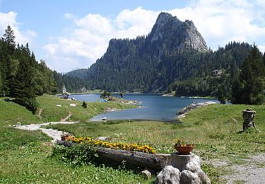
Descente sur le Lac de Taney, passage du Col de Taney et direction Torgon.
Montée vers les Portes de Culet et descente sur le point d''arrivée Morgins.

Höhenprofil

Ort

Land:
Switzerland
Region :
Wallis
Abteilung/Provinz :
Monthey
Kommune :
Saint-Gingolph
Standort:
Unknown
Gehen Sie:(Dec)
Gehen Sie:(UTM)
331327 ; 5139932 (32T) N.

Touren in der Umgebung

Tour Mountainbike Saint-Gingolph - TransAlpes VTT - 01/25 - St Gingolf - Lac de Tanay - Photo
Mountainbike
tracegps

Mountainbike

Schwierig
Saint-Gingolph, Wallis, Monthey, Switzerland
13,8 km | 27 km-effort
2h 30min
Nein
Tour Mountainbike Port-Valais - st gingolf - Photo
Mountainbike
tintin73

Mountainbike

Schwierig
Port-Valais, Wallis, Monthey, Switzerland
29 km | 45 km-effort
3h 24min
Nein
Tour Wandern Thollon-les-Mémises - 15 juillet - Photo
Wandern
Huangdi

Wandern

Sehr leicht
Thollon-les-Mémises, Auvergne-Rhone-Alpen, Hochsavoyen, France
10,8 km | 26 km-effort
4h 27min
Nein
Tour Andere Aktivitäten Saint-Gingolph - bdx001_0623 - Photo
Andere Aktivitäten
GUIDE+

Andere Aktivitäten

Sehr leicht
Saint-Gingolph, Wallis, Monthey, Switzerland
11,3 km | 35 km-effort
8h 5min
Nein
Tour Andere Aktivitäten Saint-Gingolph - ST_harlin_test - Photo
Andere Aktivitäten
GUIDE+

Andere Aktivitäten

Sehr leicht
Saint-Gingolph, Auvergne-Rhone-Alpen, Hochsavoyen, France
32 km | 84 km-effort
14h 44min
Nein
Tour Andere Aktivitäten Le Léman (VS) - bdr99_StGingolphe_Leysin - Photo
Andere Aktivitäten
GUIDE+

Andere Aktivitäten

Sehr leicht
Le Léman (VS), Wallis, Monthey, Switzerland
26 km | 38 km-effort
8h 59min
Nein
Tour Andere Aktivitäten Le Léman (VS) - bdr01_StGingolphe_Trient - Photo
Andere Aktivitäten
GUIDE+

Andere Aktivitäten

Sehr leicht
Le Léman (VS), Wallis, Monthey, Switzerland
68 km | 170 km-effort
40h 54min
Nein
Tour Andere Aktivitäten Saint-Gingolph - xxx20_Heremence_StGingolphe - Photo
Andere Aktivitäten
GUIDE+

Andere Aktivitäten

Sehr leicht
Saint-Gingolph, Wallis, Monthey, Switzerland
59 km | 59 km-effort
13h 24min
Nein
Tour Wandern Novel - Novel - Pic Boré via col de Blanchard - Photo
Wandern
marcel.F

Wandern

Schwierig
Novel, Auvergne-Rhone-Alpen, Hochsavoyen, France
12,8 km | 25 km-effort
7h 13min
Ja


Schließen
Meine Abonnements