![](/images/other/stat-length.png)
![Tour Auto Les Hauts-de-Chée - Colombey les 2 églises et le lac du Der depuis Les Hauts de Chée - Photo](https://media.geolcdn.com/t/1900/400/9428fe68-1bea-4a63-b3ae-4ab21133fd3d.jpg&format=pjpeg&maxdim=2)
Colombey les 2 églises et le lac du Der depuis Les Hauts de Chée
flzanichelli
Benutzer
![Länge](/images/other/stat-length.png)
Länge
248 km
![Maximale Höhe](https://static1.geolcdn.com/siteimages/upload/files/1508320355ic_sort_altitude_max_24dp.png)
Maximale Höhe
385 m
![Positive Höhendifferenz](https://static1.geolcdn.com/siteimages/upload/files/1508320355ic_sort_den_pos_24dp.png)
Positive Höhendifferenz
2877 m
![Km-Effort](/images/other/stat-length.png)
Km-Effort
286 km
![Min. Höhe](https://static1.geolcdn.com/siteimages/upload/files/1508320355ic_sort_altitude_min_24dp.png)
Min. Höhe
118 m
![Negative Höhendifferenz](https://static1.geolcdn.com/siteimages/upload/files/1508320355ic_sort_den_neg_24dp.png)
Negative Höhendifferenz
2877 m
![Boucle](https://static1.geolcdn.com/siteimages/upload/files/16400158638029165_repeat_loop_refresh_sync_direction_icon.png)
Boucle
Ja
Erstellungsdatum :
2020-07-13 06:29:22.134
Letzte Änderung :
2020-07-14 11:54:37.531
![Auto](https://static1.geolcdn.com/sitytour/trail-icons/401.png)
4h27
Schwierigkeit : Sehr leicht
![Scannen Sie diesen QR-Code, um die Tour in der SityTrail-Anwendung zu öffnen](https://capi.geolives.com/qq0zvz2zws4bq2lad0pu/sitytour/trails/2474167/qr.png?size=200)
Kostenlosegpshiking-Anwendung
Über SityTrail
Tour Auto von 248 km verfügbar auf Großer Osten, Meuse, Les Hauts-de-Chée. Diese Tour wird von flzanichelli vorgeschlagen.
Beschreibung
Ballade de la Meuse à l'aube
La Boisserie, le mémorial de Charles De Gaulle, la croix de Lorraine. L' Abbaye de Clairevaux. Le lac du Der et ses sports nautiques...un air de vacances au bord de l'eau.
Ort
Land:
France
Region :
Großer Osten
Abteilung/Provinz :
Meuse
Kommune :
Les Hauts-de-Chée
Standort:
Unknown
Gehen Sie:(Dec)
Gehen Sie:(UTM)
658258 ; 5414625 (31U) N.
Kommentare
Touren in der Umgebung
![Tour Fahrrad Les Hauts-de-Chée - Découverte des Eoliennes - Condé-en-Barrois - Photo](https://media.geolcdn.com/t/375/260/ext.jpg?maxdim=2&url=https%3A%2F%2Fservices.sitytrail.com%2FGeolivesWS%2FDownloadMedia.ashx%3FTrailID%3D111139%26Media%3D6506_5.jpg)
![Fahrrad Fahrrad](https://static1.geolcdn.com/sitytour/trail-icons/200.png)
Découverte des Eoliennes - Condé-en-Barrois
Fahrrad
Medium
Les Hauts-de-Chée,
Großer Osten,
Meuse,
France
![](/images/other/stat-length.png)
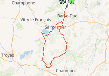
19,4 km | 23 km-effort
2h 0min
![](https://static1.geolcdn.com/siteimages/upload/files/16400158638029165_repeat_loop_refresh_sync_direction_icon.png)
Ja
![Tour Elektrofahrrad Les Hauts-de-Chée - Boucle Génicourt - Marat - Hargeville - Génicourt - Photo](https://media.geolcdn.com/t/375/260/ext.jpg?maxdim=2&url=https%3A%2F%2Fstatic1.geolcdn.com%2Fsiteimages%2Fupload%2Ffiles%2F1524743154velo.jpg)
![Elektrofahrrad Elektrofahrrad](https://static1.geolcdn.com/sitytour/trail-icons/205.png)
Boucle Génicourt - Marat - Hargeville - Génicourt
Elektrofahrrad
Sehr leicht
Les Hauts-de-Chée,
Großer Osten,
Meuse,
France
![](/images/other/stat-length.png)
13,6 km | 16,1 km-effort
1h 7min
![](https://static1.geolcdn.com/siteimages/upload/files/16400158638029165_repeat_loop_refresh_sync_direction_icon.png)
Ja
![Tour Andere Aktivitäten Les Hauts-de-Chée - Génicourt / Vavincourt - Photo](https://media.geolcdn.com/t/375/260/ext.jpg?maxdim=2&url=https%3A%2F%2Fstatic1.geolcdn.com%2Fsiteimages%2Fupload%2Ffiles%2F1545311037marcheuse_200dpi.jpg)
![Andere Aktivitäten Andere Aktivitäten](https://static1.geolcdn.com/sitytour/trail-icons/900.png)
Génicourt / Vavincourt
Andere Aktivitäten
Sehr leicht
Les Hauts-de-Chée,
Großer Osten,
Meuse,
France
![](/images/other/stat-length.png)
13,4 km | 15,3 km-effort
23min
![](https://static1.geolcdn.com/siteimages/upload/files/16400158638029165_repeat_loop_refresh_sync_direction_icon.png)
Ja
![Tour Mountainbike Les Hauts-de-Chée - Bel Com chez - Photo](https://media.geolcdn.com/t/375/260/ext.jpg?maxdim=2&url=https%3A%2F%2Fstatic1.geolcdn.com%2Fsiteimages%2Fupload%2Ffiles%2F1524743154velo.jpg)
![Mountainbike Mountainbike](https://static1.geolcdn.com/sitytour/trail-icons/202.png)
Bel Com chez
Mountainbike
Les Hauts-de-Chée,
Großer Osten,
Meuse,
France
![](/images/other/stat-length.png)
46 km | 54 km-effort
3h 25min
![](https://static1.geolcdn.com/siteimages/upload/files/16400158638029165_repeat_loop_refresh_sync_direction_icon.png)
Ja
![Tour Wandern Vavincourt - vavincourt-gare meuse TGV - Photo](https://media.geolcdn.com/t/375/260/ext.jpg?maxdim=2&url=https%3A%2F%2Fstatic1.geolcdn.com%2Fsiteimages%2Fupload%2Ffiles%2F1553511878bg_sport_marche.png)
![Wandern Wandern](https://static1.geolcdn.com/sitytour/trail-icons/101.png)
vavincourt-gare meuse TGV
Wandern
Medium
Vavincourt,
Großer Osten,
Meuse,
France
![](/images/other/stat-length.png)
26 km | 32 km-effort
6h 8min
![](https://static1.geolcdn.com/siteimages/upload/files/16400158638029165_repeat_loop_refresh_sync_direction_icon.png)
Nein
![Tour Elektrofahrrad Les Hauts-de-Chée - De Génicourt à la forêt de Rosnes - Photo](https://media.geolcdn.com/t/375/260/ext.jpg?maxdim=2&url=https%3A%2F%2Fstatic1.geolcdn.com%2Fsiteimages%2Fupload%2Ffiles%2F1524743154velo.jpg)
![Elektrofahrrad Elektrofahrrad](https://static1.geolcdn.com/sitytour/trail-icons/205.png)
De Génicourt à la forêt de Rosnes
Elektrofahrrad
Sehr leicht
Les Hauts-de-Chée,
Großer Osten,
Meuse,
France
![](/images/other/stat-length.png)
21 km | 25 km-effort
1h 28min
![](https://static1.geolcdn.com/siteimages/upload/files/16400158638029165_repeat_loop_refresh_sync_direction_icon.png)
Nein
![Tour Reiten Chardogne - rando Chardogne/conde/remb/vaub - Photo](https://media.geolcdn.com/t/375/260/ext.jpg?maxdim=2&url=https%3A%2F%2Fstatic1.geolcdn.com%2Fsiteimages%2Fupload%2Ffiles%2F1524743154cheval.jpg)
![Reiten Reiten](https://static1.geolcdn.com/sitytour/trail-icons/301.png)
rando Chardogne/conde/remb/vaub
Reiten
Medium
Chardogne,
Großer Osten,
Meuse,
France
![](/images/other/stat-length.png)
20 km | 23 km-effort
3h 2min
![](https://static1.geolcdn.com/siteimages/upload/files/16400158638029165_repeat_loop_refresh_sync_direction_icon.png)
Nein
![Tour Elektrofahrrad Les Hauts-de-Chée - Aérodrome Sud Meusien - Photo](https://media.geolcdn.com/t/375/260/ext.jpg?maxdim=2&url=https%3A%2F%2Fstatic1.geolcdn.com%2Fsiteimages%2Fupload%2Ffiles%2F1524743154velo.jpg)
![Elektrofahrrad Elektrofahrrad](https://static1.geolcdn.com/sitytour/trail-icons/205.png)
Aérodrome Sud Meusien
Elektrofahrrad
Sehr leicht
Les Hauts-de-Chée,
Großer Osten,
Meuse,
France
![](/images/other/stat-length.png)
4,8 km | 5,6 km-effort
29min
![](https://static1.geolcdn.com/siteimages/upload/files/16400158638029165_repeat_loop_refresh_sync_direction_icon.png)
Ja