![](/images/other/stat-length.png)
![Tour Zu Fuß Jarjayes - Autour de Puy Maurel - Photo](https://media.geolcdn.com/t/1900/400/ext.pjpeg?maxdim=2&url=https%3A%2F%2Fstatic1.geolcdn.com%2Fsiteimages%2Fupload%2Ffiles%2F1545311037marcheuse_200dpi.jpg)
Autour de Puy Maurel
rigol05
Benutzer
![Länge](/images/other/stat-length.png)
![Maximale Höhe](https://static1.geolcdn.com/siteimages/upload/files/1508320355ic_sort_altitude_max_24dp.png)
![Positive Höhendifferenz](https://static1.geolcdn.com/siteimages/upload/files/1508320355ic_sort_den_pos_24dp.png)
![Km-Effort](/images/other/stat-length.png)
![Min. Höhe](https://static1.geolcdn.com/siteimages/upload/files/1508320355ic_sort_altitude_min_24dp.png)
![Negative Höhendifferenz](https://static1.geolcdn.com/siteimages/upload/files/1508320355ic_sort_den_neg_24dp.png)
![Boucle](https://static1.geolcdn.com/siteimages/upload/files/16400158638029165_repeat_loop_refresh_sync_direction_icon.png)
![Zu Fuß](https://static1.geolcdn.com/sitytour/trail-icons/100.png)
--
Schwierigkeit : Medium
![Scannen Sie diesen QR-Code, um die Tour in der SityTrail-Anwendung zu öffnen](https://capi.geolives.com/qq0zvz2zws4bq2lad0pu/sitytour/trails/2468049/qr.png?size=200)
Kostenlosegpshiking-Anwendung
Über SityTrail
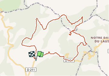
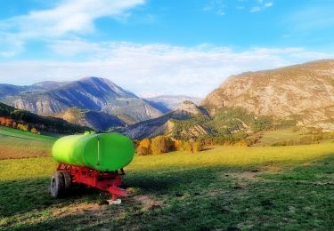
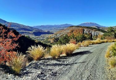
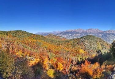
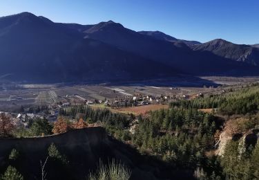
Tour Zu Fuß von 12,5 km verfügbar auf Provence-Alpes-Côte d'Azur, Hochalpen, Jarjayes. Diese Tour wird von rigol05 vorgeschlagen.
Beschreibung
Randonnée du 05/08/2020 - Départ Jarjayes parking (petit) cimetière de St.Pierre
Suivre le balisage jaune du départ du sentier ,puis la route et la piste jusqu'à la Sarrière. Quitter le balisage et emprunter N NE le sentier montant à la crête de Blache Coutière. Le suivre jusqu'à la côte 1112m. Descendre SE, rejoindre une exploitation agricole puis la route goudronnée. Attention ce tronçon traverse une propriété privée. Monter au Puy Maurel, suivre le balisage jaune, Col du Tourrond et route goudronnée jusqu'au stationnement
Ort
Kommentare
Touren in der Umgebung
![Tour Wandern Jarjayes - VALSAIRES CHAPELLE NOTRE DAME DU LAIS - Photo](https://media.geolcdn.com/t/375/260/860e51d5-4111-42e4-9649-8920f6056baf.jpg&format=jpg&maxdim=2)
![Wandern Wandern](https://static1.geolcdn.com/sitytour/trail-icons/101.png)
Wandern
![](/images/other/stat-length.png)
![](https://static1.geolcdn.com/siteimages/upload/files/16400158638029165_repeat_loop_refresh_sync_direction_icon.png)
![Tour Wandern Remollon - Remollon-un-tresor-cache-de-la-vallee-de-la-durance - Photo](https://media.geolcdn.com/t/375/260/073a624b-9a54-4ca5-a179-7003c0d6383d.jpg&format=jpg&maxdim=2)
![Wandern Wandern](https://static1.geolcdn.com/sitytour/trail-icons/101.png)
Wandern
![](/images/other/stat-length.png)
![](https://static1.geolcdn.com/siteimages/upload/files/16400158638029165_repeat_loop_refresh_sync_direction_icon.png)
![Tour Wandern Remollon - Des Demoiselles Coiffées aux balcons de Remollon - Photo](https://media.geolcdn.com/t/375/260/2094a0e8-535c-4f81-bf59-f1f898a15092.jpg&format=jpg&maxdim=2)
![Wandern Wandern](https://static1.geolcdn.com/sitytour/trail-icons/101.png)
Wandern
![](/images/other/stat-length.png)
![](https://static1.geolcdn.com/siteimages/upload/files/16400158638029165_repeat_loop_refresh_sync_direction_icon.png)
![Tour Elektrofahrrad Remollon - Le Puy et la Chapelle Saint-Sixte Via Remollon (Vélo) - Photo](https://media.geolcdn.com/t/375/260/9848f8cc-dc59-4eb7-862a-9f5bf908e081.jpg&format=jpg&maxdim=2)
![Elektrofahrrad Elektrofahrrad](https://static1.geolcdn.com/sitytour/trail-icons/205.png)
Elektrofahrrad
![](/images/other/stat-length.png)
![](https://static1.geolcdn.com/siteimages/upload/files/16400158638029165_repeat_loop_refresh_sync_direction_icon.png)
![Tour Elektrofahrrad Remollon - VTT-ae - Mont Colombis via Valserres - Croix des prés - Photo](https://media.geolcdn.com/t/375/260/cae6d5f9-a8e8-4077-ab5a-04e6867e007f.jpg&format=jpg&maxdim=2)
![Elektrofahrrad Elektrofahrrad](https://static1.geolcdn.com/sitytour/trail-icons/205.png)
Elektrofahrrad
![](/images/other/stat-length.png)
![](https://static1.geolcdn.com/siteimages/upload/files/16400158638029165_repeat_loop_refresh_sync_direction_icon.png)
![Tour Mountainbike Remollon - VTT-ae - La Croix des Prés avec V&H - Photo](https://media.geolcdn.com/t/375/260/9b08ae67-d798-4978-a9ac-e62d1c938cfe.jpg&format=jpg&maxdim=2)
![Mountainbike Mountainbike](https://static1.geolcdn.com/sitytour/trail-icons/202.png)
Mountainbike
![](/images/other/stat-length.png)
![](https://static1.geolcdn.com/siteimages/upload/files/16400158638029165_repeat_loop_refresh_sync_direction_icon.png)
![Tour Wandern Remollon - REMOLON Les demoiselles coiffées, Chapelle S Philippine .Tueuse o n l - Photo](https://media.geolcdn.com/t/375/260/0cbb9a09-f191-4c7c-af26-e28f897b633e.jpg&format=jpg&maxdim=2)
![Wandern Wandern](https://static1.geolcdn.com/sitytour/trail-icons/101.png)
Wandern
![](/images/other/stat-length.png)
![](https://static1.geolcdn.com/siteimages/upload/files/16400158638029165_repeat_loop_refresh_sync_direction_icon.png)
![Tour Wandern Remollon - Le Balcon de Remollon - Photo](https://media.geolcdn.com/t/375/260/96fc6b22-1a87-42f0-8bd0-326bf7c90e88.jpg&format=jpg&maxdim=2)
![Wandern Wandern](https://static1.geolcdn.com/sitytour/trail-icons/101.png)
Wandern
![](/images/other/stat-length.png)
![](https://static1.geolcdn.com/siteimages/upload/files/16400158638029165_repeat_loop_refresh_sync_direction_icon.png)
![Tour Wandern Saint-Étienne-le-Laus - N.D. du Laus - Col de l'Ange - Photo](https://media.geolcdn.com/t/375/260/3c060a35-f9ba-4b2a-aa26-bf027944e5fb.jpg&format=jpg&maxdim=2)
![Wandern Wandern](https://static1.geolcdn.com/sitytour/trail-icons/101.png)
Wandern
![](/images/other/stat-length.png)
![](https://static1.geolcdn.com/siteimages/upload/files/16400158638029165_repeat_loop_refresh_sync_direction_icon.png)