


13,6 km | 14,8 km-effort


Benutzer


Kostenlosegpshiking-Anwendung
 SityTrail
IGN / Geografische Institute
SityTrail World
Die Welt öffnet sich für Sie
Tour Wandern von 14,4 km verfügbar auf Okzitanien, Gard, Pujaut. Diese Tour wird von dansmabulle vorgeschlagen.
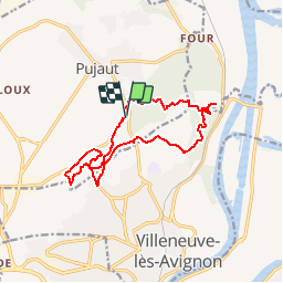
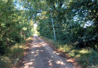
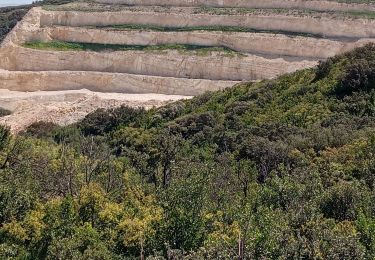
PUJAUT - FALAISES DE PUJAUT
14.5 Km - 05h00 Hrs
Départ randonnée : Au Sud de Pujaut sur la route d'Avignon. Des falaises de Pujaut au château pointu(variante) : 14km400.dénivelé cumulé :515m .amplitude :115m.Variante des « falaises de pujaut » qui comprend en plus1) un aller-retour du château pointu à la tour de la Caramude…il en reste une enceinte de moins de 2m de hauteur qui peut vous servir d’abris contre le Mistral. On domine en plus de la vallée du Rhône, une immense carrière.L’accès de la tour se fait le long d’une limite …que l’on peut franchir, qui est là pour prévenir de ne pas s’approcher de la « falaise de la carrière » pour risque de chute mais aussi de tir de mines(préférer donc un week end).2) Une « boucle » qui vous fait descendre au pied puis le long des falaises de Pujaut pour remonter par un sentier bordé par des buis. Attention la descente peut en rebuter certains, elle est parfois raide(ce n’est pas de l’escalade, on ne met jamais les mains…) dans un sentier d’éboulis.(Et par fort Mistral ça a été le passage le plus impressionnant….)Note :a) Au niveau des carrières du mas de Carles après la partie grillagée, sur votre gauche soyez attentif vous pourrez apercevoir une petite entrée des « grottes des carrières » et aller y faire une petite exploration.b)La partie du château pointu peut faire l’objet de battus de sangliers, des joggeurs ont été refoulés , devant notre groupe(12) ils (les chasseurs) nous ont laissés passer.Pour info : OUVERTURE GENERALE : 25 septembre 2011- FERMETURE GENERALE : 29 février 2012. Bonne randonnée
Wandern
Wandern
Wandern
Wandern
Wandern
Wandern
Wandern

Laufen
Radtourismus