![](/images/other/stat-length.png)
![Tour Wandern Villeneuve-lès-Avignon - VILLENEUVE LES AVIGNON - PUJAUT - FALAISES DE PUJAUT - 11.3Km - 04h00 - Dénivelé 230 m - Photo](https://media.geolcdn.com/t/1900/400/ext.pjpeg?maxdim=2&url=https%3A%2F%2Fstatic1.geolcdn.com%2Fsiteimages%2Fupload%2Ffiles%2F1553511878bg_sport_marche.png)
VILLENEUVE LES AVIGNON - PUJAUT - FALAISES DE PUJAUT - 11.3Km - 04h00 - Dénivelé 230 m
dansmabulle
Benutzer
![Länge](/images/other/stat-length.png)
![Maximale Höhe](https://static1.geolcdn.com/siteimages/upload/files/1508320355ic_sort_altitude_max_24dp.png)
![Positive Höhendifferenz](https://static1.geolcdn.com/siteimages/upload/files/1508320355ic_sort_den_pos_24dp.png)
![Km-Effort](/images/other/stat-length.png)
![Min. Höhe](https://static1.geolcdn.com/siteimages/upload/files/1508320355ic_sort_altitude_min_24dp.png)
![Negative Höhendifferenz](https://static1.geolcdn.com/siteimages/upload/files/1508320355ic_sort_den_neg_24dp.png)
![Boucle](https://static1.geolcdn.com/siteimages/upload/files/16400158638029165_repeat_loop_refresh_sync_direction_icon.png)
![Wandern](https://static1.geolcdn.com/sitytour/trail-icons/101.png)
3h03
Schwierigkeit : Medium
![Scannen Sie diesen QR-Code, um die Tour in der SityTrail-Anwendung zu öffnen](https://capi.geolives.com/qq0zvz2zws4bq2lad0pu/sitytour/trails/244614/qr.png?size=200)
Kostenlosegpshiking-Anwendung
Über SityTrail
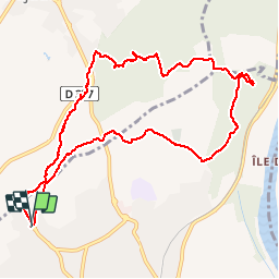
Tour Wandern von 11,2 km verfügbar auf Okzitanien, Gard, Villeneuve-lès-Avignon. Diese Tour wird von dansmabulle vorgeschlagen.
Beschreibung
11.3Km - 04:00 Hrs
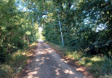
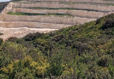
Départ randonnée : Ecole Joseph L'Hermitte à Villeneuve-les-Avignon Gard 30) Des falaises de Pujaut au château pointu : 11km.dénivelé cumulé :292m .amplitude :75m.Départ 9h du Parking de l’école primaire Joseph Lhermitte.Arrivé 15h30.Parcours très varié, à découvrir, avec ses panoramas magnifiques, vous faisant passer des falaises de villeneuve les avignon avec son château pointu :point de vue sur le rhône, Avignon et les toutes les montagnes à l’est(ventoux,alpilles,….)Aux falaises de Pujaut :vue à l’ouest sur les vignobles de tavel, « l’étang » de pujaut et les montagnes du Gard et au nord jusqu’à chateauneuf du pape…. Bonne randonnée
Ort
Kommentare
Touren in der Umgebung
![Tour Wandern Avignon - ile de la Barthelasse - Photo](https://media.geolcdn.com/t/375/260/e0f4fcd0-18e6-4d74-a6c3-369037188a72.jpg&format=jpg&maxdim=2)
![Wandern Wandern](https://static1.geolcdn.com/sitytour/trail-icons/101.png)
Wandern
![](/images/other/stat-length.png)
![](https://static1.geolcdn.com/siteimages/upload/files/16400158638029165_repeat_loop_refresh_sync_direction_icon.png)
![Tour Wandern Avignon - ile de Barthelasse 1ere du top 10 des balades d Avignon... pauvres avignonais... - Photo](https://media.geolcdn.com/t/375/260/963c3ee6-7875-4ee3-ace7-cd7418306cf7.jpg&format=jpg&maxdim=2)
![Wandern Wandern](https://static1.geolcdn.com/sitytour/trail-icons/101.png)
Wandern
![](/images/other/stat-length.png)
![](https://static1.geolcdn.com/siteimages/upload/files/16400158638029165_repeat_loop_refresh_sync_direction_icon.png)
![Wandern Wandern](https://static1.geolcdn.com/sitytour/trail-icons/101.png)
Wandern
![](/images/other/stat-length.png)
![](https://static1.geolcdn.com/siteimages/upload/files/16400158638029165_repeat_loop_refresh_sync_direction_icon.png)
![Tour Wandern Avignon - 2024-08-24 Barthelasse - grand bosquet - Photo](https://media.geolcdn.com/t/375/260/ad341062-73ba-4d71-afc7-9fafb7f4736e.jpg&format=jpg&maxdim=2)
![Wandern Wandern](https://static1.geolcdn.com/sitytour/trail-icons/101.png)
Wandern
![](/images/other/stat-length.png)
![](https://static1.geolcdn.com/siteimages/upload/files/16400158638029165_repeat_loop_refresh_sync_direction_icon.png)
![Tour Wandern Sauveterre - le hameau du four - Photo](https://media.geolcdn.com/t/375/260/50208cfd-9337-4f55-8c59-517d70d95b0c.jpg&format=jpg&maxdim=2)
![Wandern Wandern](https://static1.geolcdn.com/sitytour/trail-icons/101.png)
Wandern
![](/images/other/stat-length.png)
![](https://static1.geolcdn.com/siteimages/upload/files/16400158638029165_repeat_loop_refresh_sync_direction_icon.png)
![Tour Wandern Avignon - baguenaudage en Avignon - Photo](https://media.geolcdn.com/t/375/260/307f00c2-1f87-43b1-84c1-7a62203d52aa.jpg&format=jpg&maxdim=2)
![Wandern Wandern](https://static1.geolcdn.com/sitytour/trail-icons/101.png)
Wandern
![](/images/other/stat-length.png)
![](https://static1.geolcdn.com/siteimages/upload/files/16400158638029165_repeat_loop_refresh_sync_direction_icon.png)
![Tour Laufen Avignon - running hopital - Photo](https://media.geolcdn.com/t/375/260/ext.jpg?maxdim=2&url=https%3A%2F%2Fstatic1.geolcdn.com%2Fsiteimages%2Fupload%2Ffiles%2F1524743154running.jpg)
![Laufen Laufen](https://static1.geolcdn.com/sitytour/trail-icons/103.png)
Laufen
![](/images/other/stat-length.png)
![](https://static1.geolcdn.com/siteimages/upload/files/16400158638029165_repeat_loop_refresh_sync_direction_icon.png)
![Tour Radtourismus Les Angles - Avant dernière étape - Photo](https://media.geolcdn.com/t/375/260/77ee41c0-83af-4a4a-a427-853d84ab2441.jpg&format=jpg&maxdim=2)
![Radtourismus Radtourismus](https://static1.geolcdn.com/sitytour/trail-icons/204.png)
Radtourismus
![](/images/other/stat-length.png)
![](https://static1.geolcdn.com/siteimages/upload/files/16400158638029165_repeat_loop_refresh_sync_direction_icon.png)
![Tour Mountainbike Villeneuve-lès-Avignon - Rando VTT du Fort Saint André 2018 35km - Photo](https://media.geolcdn.com/t/375/260/ext.jpg?maxdim=2&url=https%3A%2F%2Fservices.sitytrail.com%2FGeolivesWS%2FDownloadMedia.ashx%3FTrailID%3D1056111%26Media%3Dfix__20181013164618.jpg)
![Mountainbike Mountainbike](https://static1.geolcdn.com/sitytour/trail-icons/202.png)
Mountainbike
![](/images/other/stat-length.png)
![](https://static1.geolcdn.com/siteimages/upload/files/16400158638029165_repeat_loop_refresh_sync_direction_icon.png)