![](/images/other/stat-length.png)
![Tour Andere Aktivitäten Lucens - Sentier Aventures Lucens - Cremin - Photo](https://media.geolcdn.com/t/1900/400/ext.pjpeg?maxdim=2&url=https%3A%2F%2Fstatic1.geolcdn.com%2Fsiteimages%2Fupload%2Ffiles%2F1545311037marcheuse_200dpi.jpg)
Sentier Aventures Lucens - Cremin
necira
Benutzer
![Länge](/images/other/stat-length.png)
Länge
5,4 km
![Maximale Höhe](https://static1.geolcdn.com/siteimages/upload/files/1508320355ic_sort_altitude_max_24dp.png)
Maximale Höhe
665 m
![Positive Höhendifferenz](https://static1.geolcdn.com/siteimages/upload/files/1508320355ic_sort_den_pos_24dp.png)
Positive Höhendifferenz
178 m
![Km-Effort](/images/other/stat-length.png)
Km-Effort
7,7 km
![Min. Höhe](https://static1.geolcdn.com/siteimages/upload/files/1508320355ic_sort_altitude_min_24dp.png)
Min. Höhe
547 m
![Negative Höhendifferenz](https://static1.geolcdn.com/siteimages/upload/files/1508320355ic_sort_den_neg_24dp.png)
Negative Höhendifferenz
174 m
![Boucle](https://static1.geolcdn.com/siteimages/upload/files/16400158638029165_repeat_loop_refresh_sync_direction_icon.png)
Boucle
Ja
Erstellungsdatum :
2014-12-11 00:00:00.0
Letzte Änderung :
2014-12-11 00:00:00.0
![Andere Aktivitäten](https://static1.geolcdn.com/sitytour/trail-icons/900.png)
--
Schwierigkeit : Unbekannt
![Scannen Sie diesen QR-Code, um die Tour in der SityTrail-Anwendung zu öffnen](https://capi.geolives.com/qq0zvz2zws4bq2lad0pu/sitytour/trails/24446/qr.png?size=200)
Kostenlosegpshiking-Anwendung
Über SityTrail
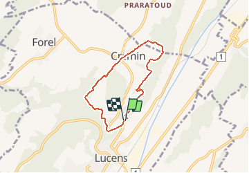
Tour Andere Aktivitäten von 5,4 km verfügbar auf Waadt, District de la Broye-Vully, Lucens. Diese Tour wird von necira vorgeschlagen.
Beschreibung
Sortie en famille
En saison on y trouve des Ancolies juste après le pont suspendu ainsi que du muguet juste après la Pointe de Cremin.
Ort
Land:
Switzerland
Region :
Waadt
Abteilung/Provinz :
District de la Broye-Vully
Kommune :
Lucens
Standort:
Lucens
Gehen Sie:(Dec)
Gehen Sie:(UTM)
335110 ; 5175731 (32T) N.
Kommentare
Touren in der Umgebung
![Tour Wandern Valbroye - wa13 - Photo](https://media.geolcdn.com/t/375/260/ext.jpg?maxdim=2&url=https%3A%2F%2Fstatic1.geolcdn.com%2Fsiteimages%2Fupload%2Ffiles%2F1553511878bg_sport_marche.png)
![Wandern Wandern](https://static1.geolcdn.com/sitytour/trail-icons/101.png)
wa13
Wandern
Sehr leicht
Valbroye,
Waadt,
District de la Broye-Vully,
Switzerland
![](/images/other/stat-length.png)
34 km | 45 km-effort
Unbekannt
![](https://static1.geolcdn.com/siteimages/upload/files/16400158638029165_repeat_loop_refresh_sync_direction_icon.png)
Nein
![Tour Andere Aktivitäten Villars-le-Comte - VILLARS-LE-COMTE - Photo](https://media.geolcdn.com/t/375/260/ext.jpg?maxdim=2&url=https%3A%2F%2Fstatic1.geolcdn.com%2Fsiteimages%2Fupload%2Ffiles%2F1545311037marcheuse_200dpi.jpg)
![Andere Aktivitäten Andere Aktivitäten](https://static1.geolcdn.com/sitytour/trail-icons/900.png)
VILLARS-LE-COMTE
Andere Aktivitäten
Sehr leicht
Villars-le-Comte,
Waadt,
District de la Broye-Vully,
Switzerland
![](/images/other/stat-length.png)
11,1 km | 14,7 km-effort
Unbekannt
![](https://static1.geolcdn.com/siteimages/upload/files/16400158638029165_repeat_loop_refresh_sync_direction_icon.png)
Ja
![Tour Andere Aktivitäten Moudon - chapelle - Photo](https://media.geolcdn.com/t/375/260/ext.jpg?maxdim=2&url=https%3A%2F%2Fstatic1.geolcdn.com%2Fsiteimages%2Fupload%2Ffiles%2F1545311037marcheuse_200dpi.jpg)
![Andere Aktivitäten Andere Aktivitäten](https://static1.geolcdn.com/sitytour/trail-icons/900.png)
chapelle
Andere Aktivitäten
Sehr leicht
Moudon,
Waadt,
District de la Broye-Vully,
Switzerland
![](/images/other/stat-length.png)
5,8 km | 8,2 km-effort
Unbekannt
![](https://static1.geolcdn.com/siteimages/upload/files/16400158638029165_repeat_loop_refresh_sync_direction_icon.png)
Ja
![Tour Andere Aktivitäten Lucens - De Lucens à Thierrens, en longeant la Cerjaule - Photo](https://media.geolcdn.com/t/375/260/ext.jpg?maxdim=2&url=https%3A%2F%2Fstatic1.geolcdn.com%2Fsiteimages%2Fupload%2Ffiles%2F1545311037marcheuse_200dpi.jpg)
![Andere Aktivitäten Andere Aktivitäten](https://static1.geolcdn.com/sitytour/trail-icons/900.png)
De Lucens à Thierrens, en longeant la Cerjaule
Andere Aktivitäten
Sehr leicht
(1)
Lucens,
Waadt,
District de la Broye-Vully,
Switzerland
![](/images/other/stat-length.png)
10 km | 14,9 km-effort
Unbekannt
![](https://static1.geolcdn.com/siteimages/upload/files/16400158638029165_repeat_loop_refresh_sync_direction_icon.png)
Nein
![Tour Wandern Moudon - Circuit de Moudon à Hermenches - Photo](https://media.geolcdn.com/t/375/260/ext.jpg?maxdim=2&url=https%3A%2F%2Fstatic1.geolcdn.com%2Fsiteimages%2Fupload%2Ffiles%2F1553511878bg_sport_marche.png)
![Wandern Wandern](https://static1.geolcdn.com/sitytour/trail-icons/101.png)
Circuit de Moudon à Hermenches
Wandern
Einfach
Moudon,
Waadt,
District de la Broye-Vully,
Switzerland
![](/images/other/stat-length.png)
15,5 km | 21 km-effort
4h 0min
![](https://static1.geolcdn.com/siteimages/upload/files/16400158638029165_repeat_loop_refresh_sync_direction_icon.png)
Ja