![](/images/other/stat-length.png)
![Tour Wandern Termes - Termes ( Aude ) + les gorges de Terminet +le Nitable roc - Photo](https://media.geolcdn.com/t/1900/400/3c7c76e3-a6e6-4917-9585-a86189afa3e6.jpg&format=pjpeg&maxdim=2)
Termes ( Aude ) + les gorges de Terminet +le Nitable roc
MarieFrancoise
Benutzer
![Länge](/images/other/stat-length.png)
![Maximale Höhe](https://static1.geolcdn.com/siteimages/upload/files/1508320355ic_sort_altitude_max_24dp.png)
![Positive Höhendifferenz](https://static1.geolcdn.com/siteimages/upload/files/1508320355ic_sort_den_pos_24dp.png)
![Km-Effort](/images/other/stat-length.png)
![Min. Höhe](https://static1.geolcdn.com/siteimages/upload/files/1508320355ic_sort_altitude_min_24dp.png)
![Negative Höhendifferenz](https://static1.geolcdn.com/siteimages/upload/files/1508320355ic_sort_den_neg_24dp.png)
![Boucle](https://static1.geolcdn.com/siteimages/upload/files/16400158638029165_repeat_loop_refresh_sync_direction_icon.png)
![Wandern](https://static1.geolcdn.com/sitytour/trail-icons/101.png)
6h57
Schwierigkeit : Medium
![Scannen Sie diesen QR-Code, um die Tour in der SityTrail-Anwendung zu öffnen](https://capi.geolives.com/qq0zvz2zws4bq2lad0pu/sitytour/trails/2442224/qr.png?size=200)
Kostenlosegpshiking-Anwendung
Über SityTrail
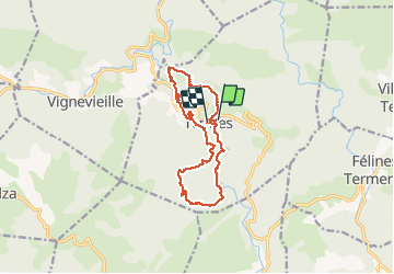
Tour Wandern von 15,8 km verfügbar auf Okzitanien, Aude, Termes. Diese Tour wird von MarieFrancoise vorgeschlagen.
Beschreibung
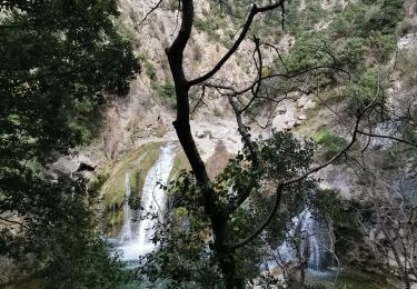
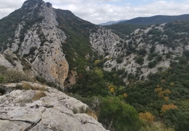
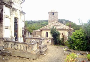
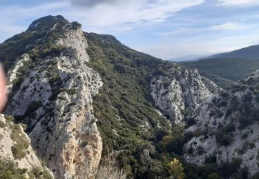
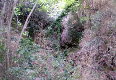
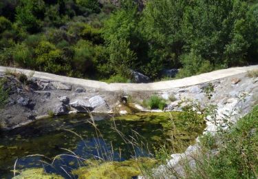
Départ du parking à l entrée de Termes.la rando se compose de 2 parties .les gorges de Termenet et le château puis en second le Nitable roc .La 1ère partie est plus jolie et on peut se baigner dans les magnifiques gorges .si on ne souhaite pas faire la seconde partie qui compte 200 m de dénivelé et environ 7 km)on peut après le château rentrer au village qui est très typique .il y a un café .
déconseillé l 'été bien que le parcours se fasse en grande partie en forêt.
il y a dans chaque partie une descente assez raide à signaler.
Ort
Kommentare
Touren in der Umgebung
![Tour Wandern Termes - Termes Nitable Roc - Photo](https://media.geolcdn.com/t/375/260/1e846430-9c95-4083-8998-af241687d490.jpg&format=jpg&maxdim=2)
![Wandern Wandern](https://static1.geolcdn.com/sitytour/trail-icons/101.png)
Wandern
![](/images/other/stat-length.png)
![](https://static1.geolcdn.com/siteimages/upload/files/16400158638029165_repeat_loop_refresh_sync_direction_icon.png)
![Tour Wandern Termes - Termes Nitable Roc - Photo](https://media.geolcdn.com/t/375/260/05d263cd-66c0-4a9b-b66b-1220e1255d5e.jpg&format=jpg&maxdim=2)
![Wandern Wandern](https://static1.geolcdn.com/sitytour/trail-icons/101.png)
Wandern
![](/images/other/stat-length.png)
![](https://static1.geolcdn.com/siteimages/upload/files/16400158638029165_repeat_loop_refresh_sync_direction_icon.png)
![Tour Wandern Termes - Termes Christophe - Photo](https://media.geolcdn.com/t/375/260/afe8174b-5e88-441e-b93d-7b8d107fe93e.jpg&format=jpg&maxdim=2)
![Wandern Wandern](https://static1.geolcdn.com/sitytour/trail-icons/101.png)
Wandern
![](/images/other/stat-length.png)
![](https://static1.geolcdn.com/siteimages/upload/files/16400158638029165_repeat_loop_refresh_sync_direction_icon.png)
![Tour Zu Fuß Félines-Termenès - Au Fil du Temps - Photo](https://media.geolcdn.com/t/375/260/6df64c81-4f12-457f-ad6a-247c9b1f1cff.jpeg&format=jpg&maxdim=2)
![Zu Fuß Zu Fuß](https://static1.geolcdn.com/sitytour/trail-icons/100.png)
Zu Fuß
![](/images/other/stat-length.png)
![](https://static1.geolcdn.com/siteimages/upload/files/16400158638029165_repeat_loop_refresh_sync_direction_icon.png)
![Tour Varia Termes - termes 1ere boucle - Photo](https://media.geolcdn.com/t/375/260/e26ca2a0-c961-4141-9e5d-edd75ef5262f.jpg&format=jpg&maxdim=2)
![Varia Varia](https://static1.geolcdn.com/sitytour/trail-icons/900.png)
Varia
![](/images/other/stat-length.png)
![](https://static1.geolcdn.com/siteimages/upload/files/16400158638029165_repeat_loop_refresh_sync_direction_icon.png)
![Wandern Wandern](https://static1.geolcdn.com/sitytour/trail-icons/101.png)
Wandern
![](/images/other/stat-length.png)
![](https://static1.geolcdn.com/siteimages/upload/files/16400158638029165_repeat_loop_refresh_sync_direction_icon.png)
![Tour Wandern Davejean - DAVEJEAN - Les petits chemins de Davejean - Photo](https://media.geolcdn.com/t/375/260/badd948f-60b6-4449-ae7e-ae4e5eeb8a04.jpg&format=jpg&maxdim=2)
![Wandern Wandern](https://static1.geolcdn.com/sitytour/trail-icons/101.png)
Wandern
![](/images/other/stat-length.png)
![](https://static1.geolcdn.com/siteimages/upload/files/16400158638029165_repeat_loop_refresh_sync_direction_icon.png)
![Tour Wandern Félines-Termenès - FELINES TERMENES - au fil du temps la pierre - Photo](https://media.geolcdn.com/t/375/260/d59645b7-7e66-47ca-bb06-8a5d10f4cd47.jpg&format=jpg&maxdim=2)
![Wandern Wandern](https://static1.geolcdn.com/sitytour/trail-icons/101.png)
Wandern
![](/images/other/stat-length.png)
![](https://static1.geolcdn.com/siteimages/upload/files/16400158638029165_repeat_loop_refresh_sync_direction_icon.png)
![Tour Wandern Termes - 11-Termes-Nitable Roc-Gorge du Terminet-30:08:2015* - Photo](https://media.geolcdn.com/t/375/260/ext.jpg?maxdim=2&url=https%3A%2F%2Fstatic1.geolcdn.com%2Fsiteimages%2Fupload%2Ffiles%2F1553511878bg_sport_marche.png)
![Wandern Wandern](https://static1.geolcdn.com/sitytour/trail-icons/101.png)
Wandern
![](/images/other/stat-length.png)
![](https://static1.geolcdn.com/siteimages/upload/files/16400158638029165_repeat_loop_refresh_sync_direction_icon.png)