![](/images/other/stat-length.png)
![Tour Mountainbike Clansayes - Circuit n°4 Bleu les Garigues - Photo](https://media.geolcdn.com/t/1900/400/c89acea2-82db-4826-ab86-c13f873302e6.png&format=pjpeg&maxdim=2)
Circuit n°4 Bleu les Garigues
lespoulpes
Benutzer
![Länge](/images/other/stat-length.png)
![Maximale Höhe](https://static1.geolcdn.com/siteimages/upload/files/1508320355ic_sort_altitude_max_24dp.png)
![Positive Höhendifferenz](https://static1.geolcdn.com/siteimages/upload/files/1508320355ic_sort_den_pos_24dp.png)
![Km-Effort](/images/other/stat-length.png)
![Min. Höhe](https://static1.geolcdn.com/siteimages/upload/files/1508320355ic_sort_altitude_min_24dp.png)
![Negative Höhendifferenz](https://static1.geolcdn.com/siteimages/upload/files/1508320355ic_sort_den_neg_24dp.png)
![Boucle](https://static1.geolcdn.com/siteimages/upload/files/16400158638029165_repeat_loop_refresh_sync_direction_icon.png)
![Mountainbike](https://static1.geolcdn.com/sitytour/trail-icons/202.png)
55m
Schwierigkeit : Einfach
![Scannen Sie diesen QR-Code, um die Tour in der SityTrail-Anwendung zu öffnen](https://capi.geolives.com/qq0zvz2zws4bq2lad0pu/sitytour/trails/2437630/qr.png?size=200)
Kostenlosegpshiking-Anwendung
Über SityTrail
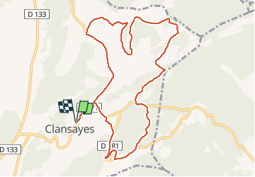
Tour Mountainbike von 11,7 km verfügbar auf Auvergne-Rhone-Alpen, Drôme, Clansayes. Diese Tour wird von lespoulpes vorgeschlagen.
Beschreibung
4 - FACILE | 12 km | 130 m déniv. | 1h15 Départ : Clansayes
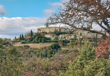
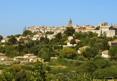
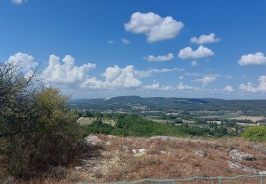
À la découverte du plateau de Clansayes, village surmonté d’une tour et de sa vierge perchée, entre chênes et lavandes, vous parcourerez de beaux sentiers et profiterez de panoramas tout le long du parcours.
Parcours :
DÉPART : Place du village (point d’eau au cimetière). Tourner à gauche sur la route du plateau et continuer tout droit sur environ 2 km.
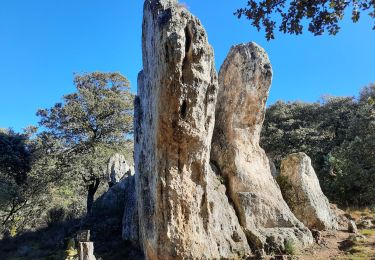
1. Prendre à droite un magnifique sentier en sous-bois, puis un chemin jusqu'à une petite route.
2,2 km
2. Tourner à gauche et monter jusqu'à prendre sur votre droite un sentier au milieu de genêts. Monter à gauche jusqu'à atteindre une belle maison sur le plateau.
3km
3. Continuer sur un large chemin jusqu'au poteau " Les Homais " (alt. 304 m), puis prendre à droite une monotrace en sous-bois, puis à nouveau à droite pour déboucher sur un chemin.
4,2 km
4. Tourner à droite, puis s'engager plus loin sur une monotrace en sous-bois et rejoindre un chemin pour déboucher sur une petite route.
6km
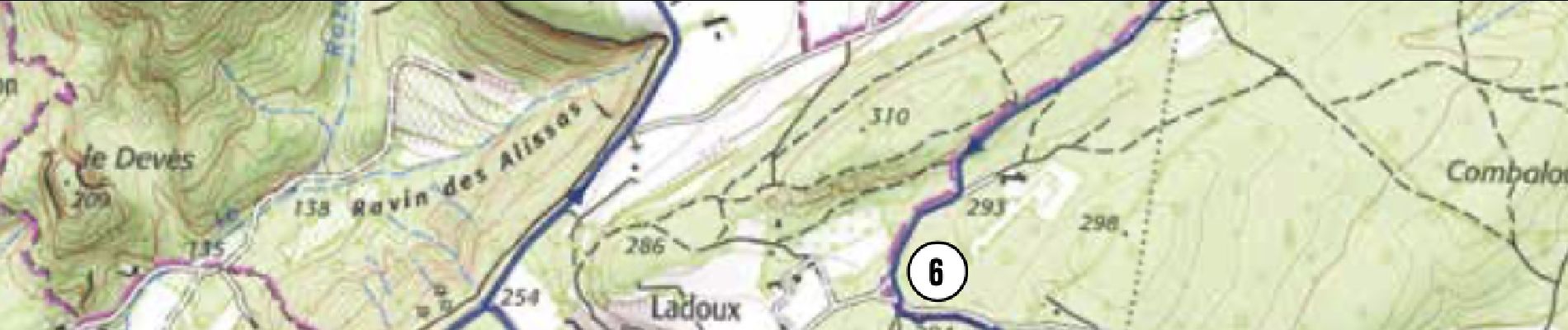
5. Tourner à gauche, puis à 80 m, à nouveau à gauche. Atteindre le poteau "Les Garrigues " (alt. 293 m). Descendre la piste à droite jusqu'à un carrefour. Attention voitures !
6,7 km
6. En face, s'engager sur un pittoresque sentier en sous-bois. Le chemin au profil descendant deviendra caillouteux par endroits.
7,8 km
7. Atteindre une route. Tourner à droite puis atteindre la belle demeure " Château Giraud ". Plus loin, rejoindre un croisement. Attention voitures !
9,1 km
8. Tourner à droite et monter le chemin du Château d'eau, puis s'engager à gauche sur un sentier ludique en sous-bois. Atteindre une route. Attention voitures !
9,5 km
9. Tourner à droite. Descendre jusqu'au poteau " Ladoux "(alt. 275 m). S'engager à gauche sur un sentier parfois technique dû à des marches naturelles, prudence ! Rejoindre un chemin puis une route. Attention voitures !
10 km
10. Tourner à gauche, descendre la route jusqu'à un croisement, puis prendre le même chemin qu'à l'aller pour rejoindre l'arrivée.
11km
ARRIVÉE : descendre jusqu'au parking du village (point d’eau).
12 km
Ort
Kommentare
Touren in der Umgebung
![Tour Wandern La Garde-Adhémar - La Garde-Adhemar Le Val des Nymphes Les Ocres 13km. - Photo](https://media.geolcdn.com/t/375/260/f22fd23a-4662-459b-bd1b-f7844383ab69.jpg&format=jpg&maxdim=2)
![Wandern Wandern](https://static1.geolcdn.com/sitytour/trail-icons/101.png)
Wandern
![](/images/other/stat-length.png)
![](https://static1.geolcdn.com/siteimages/upload/files/16400158638029165_repeat_loop_refresh_sync_direction_icon.png)
![Tour Wandern Clansayes - SityTrail - Clansayes Le Rouvergue 6km - Photo](https://media.geolcdn.com/t/375/260/de3feb6f-5587-4e87-a580-1261cf3df48e.jpg&format=jpg&maxdim=2)
![Wandern Wandern](https://static1.geolcdn.com/sitytour/trail-icons/101.png)
Wandern
![](/images/other/stat-length.png)
![](https://static1.geolcdn.com/siteimages/upload/files/16400158638029165_repeat_loop_refresh_sync_direction_icon.png)
![Tour Wandern La Garde-Adhémar - La Garde-Adhemar Val- des-Nymphes. 8,5km - Photo](https://media.geolcdn.com/t/375/260/05b3cab3-21bf-4624-90c5-6a3af96daa1d.jpg&format=jpg&maxdim=2)
![Wandern Wandern](https://static1.geolcdn.com/sitytour/trail-icons/101.png)
Wandern
![](/images/other/stat-length.png)
![](https://static1.geolcdn.com/siteimages/upload/files/16400158638029165_repeat_loop_refresh_sync_direction_icon.png)
![Tour Wandern Saint-Restitut - St Restitut Le Barry 12km - Photo](https://media.geolcdn.com/t/375/260/52d96bcf-650b-4fd0-a59a-69f2b2d3703d.jpg&format=jpg&maxdim=2)
![Wandern Wandern](https://static1.geolcdn.com/sitytour/trail-icons/101.png)
Wandern
![](/images/other/stat-length.png)
![](https://static1.geolcdn.com/siteimages/upload/files/16400158638029165_repeat_loop_refresh_sync_direction_icon.png)
![Tour Wandern Chantemerle-lès-Grignan - 2022-09-02_11h45m28_Les crevasses Le Rouvergue 14km.gpx (1).xml - Photo](https://media.geolcdn.com/t/375/260/831a71a9-7103-4579-b58f-a481dab0e6f2.jpg&format=jpg&maxdim=2)
![Wandern Wandern](https://static1.geolcdn.com/sitytour/trail-icons/101.png)
Wandern
![](/images/other/stat-length.png)
![](https://static1.geolcdn.com/siteimages/upload/files/16400158638029165_repeat_loop_refresh_sync_direction_icon.png)
![Tour Wandern Chantemerle-lès-Grignan - Les Crevasses de Chantemerle Les Grignans 7Km5 - Photo](https://media.geolcdn.com/t/375/260/cedb0d20-c0ad-495a-acf8-00c291c6b1fd.jpg&format=jpg&maxdim=2)
![Wandern Wandern](https://static1.geolcdn.com/sitytour/trail-icons/101.png)
Wandern
![](/images/other/stat-length.png)
![](https://static1.geolcdn.com/siteimages/upload/files/16400158638029165_repeat_loop_refresh_sync_direction_icon.png)
![Tour Wandern Chantemerle-lès-Grignan - Chantemerle-Les Grignan Les jumelles du Rozet Clansayes 15km - Photo](https://media.geolcdn.com/t/375/260/e778a7ff-aae4-45e1-a529-5e7212fd1471.jpg&format=jpg&maxdim=2)
![Wandern Wandern](https://static1.geolcdn.com/sitytour/trail-icons/101.png)
Wandern
![](/images/other/stat-length.png)
![](https://static1.geolcdn.com/siteimages/upload/files/16400158638029165_repeat_loop_refresh_sync_direction_icon.png)
![Tour Wandern Saint-Restitut - St Restitut Barry 14km - Photo](https://media.geolcdn.com/t/375/260/919620e4-c2f5-475b-864c-8c28884f4028.jpg&format=jpg&maxdim=2)
![Wandern Wandern](https://static1.geolcdn.com/sitytour/trail-icons/101.png)
Wandern
![](/images/other/stat-length.png)
![](https://static1.geolcdn.com/siteimages/upload/files/16400158638029165_repeat_loop_refresh_sync_direction_icon.png)
![Tour Wandern Saint-Restitut - Les carrières de Sainte Juste - Saint Restitut - Photo](https://media.geolcdn.com/t/375/260/ext.jpg?maxdim=2&url=https%3A%2F%2Fservices.sitytrail.com%2FGeolivesWS%2FDownloadMedia.ashx%3FTrailID%3D317462%26Media%3D16693_6.jpg)
![Wandern Wandern](https://static1.geolcdn.com/sitytour/trail-icons/101.png)
Wandern
![](/images/other/stat-length.png)
![](https://static1.geolcdn.com/siteimages/upload/files/16400158638029165_repeat_loop_refresh_sync_direction_icon.png)