![](/images/other/stat-length.png)
![Tour Wandern Nivelle - le tour de Nivelle par Thun et écluses de Mortagne - Photo](https://media.geolcdn.com/t/1900/400/78d714c8-4477-468a-912e-b11f83b436bd.jpg&format=pjpeg&maxdim=2)
le tour de Nivelle par Thun et écluses de Mortagne
papiou
Benutzer
![Länge](/images/other/stat-length.png)
![Maximale Höhe](https://static1.geolcdn.com/siteimages/upload/files/1508320355ic_sort_altitude_max_24dp.png)
![Positive Höhendifferenz](https://static1.geolcdn.com/siteimages/upload/files/1508320355ic_sort_den_pos_24dp.png)
![Km-Effort](/images/other/stat-length.png)
![Min. Höhe](https://static1.geolcdn.com/siteimages/upload/files/1508320355ic_sort_altitude_min_24dp.png)
![Negative Höhendifferenz](https://static1.geolcdn.com/siteimages/upload/files/1508320355ic_sort_den_neg_24dp.png)
![Boucle](https://static1.geolcdn.com/siteimages/upload/files/16400158638029165_repeat_loop_refresh_sync_direction_icon.png)
![Wandern](https://static1.geolcdn.com/sitytour/trail-icons/101.png)
2h00
Schwierigkeit : Einfach
![Scannen Sie diesen QR-Code, um die Tour in der SityTrail-Anwendung zu öffnen](https://capi.geolives.com/qq0zvz2zws4bq2lad0pu/sitytour/trails/2435686/qr.png?size=200)
Kostenlosegpshiking-Anwendung
Über SityTrail
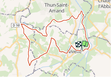
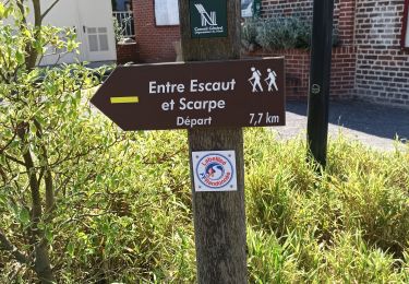
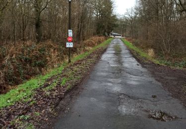
Tour Wandern von 10,5 km verfügbar auf Nordfrankreich, Nord, Nivelle. Diese Tour wird von papiou vorgeschlagen.
Beschreibung
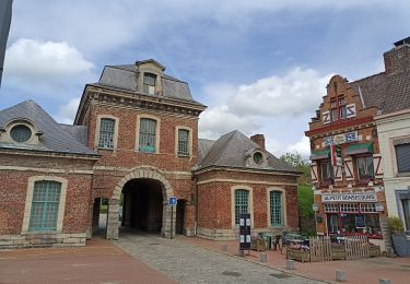
rdv hall de Nivelle près du pont de la Scarpe. en sortant du parking prendre à gauche puis passer à droite du calvaire et rejoindre le CD, prendre à gauche puis à droite et suivre le circuit sur l'appli en passant par église de Thun et écluses de Mortagne et retour par berge de la Scarpe et le pont.
Ort
Kommentare
Touren in der Umgebung
![Tour Wandern Hergnies - Entre terre et eaux - Hergnies - Photo](https://media.geolcdn.com/t/375/260/ext.jpg?maxdim=2&url=https%3A%2F%2Fservices.sitytrail.com%2FGeolivesWS%2FDownloadMedia.ashx%3FTrailID%3D111915%26Media%3D8943_6.jpg)
![Wandern Wandern](https://static1.geolcdn.com/sitytour/trail-icons/101.png)
Wandern
![](/images/other/stat-length.png)
![](https://static1.geolcdn.com/siteimages/upload/files/16400158638029165_repeat_loop_refresh_sync_direction_icon.png)
![Tour Wandern Mortagne-du-Nord - Mortagne-du-Nord 18,6 km - Photo](https://media.geolcdn.com/t/375/260/fd97f041-03e8-458c-b32d-9e5c0c535a41.jpg&format=jpg&maxdim=2)
![Wandern Wandern](https://static1.geolcdn.com/sitytour/trail-icons/101.png)
Wandern
![](/images/other/stat-length.png)
![](https://static1.geolcdn.com/siteimages/upload/files/16400158638029165_repeat_loop_refresh_sync_direction_icon.png)
![Tour Wandern Saint-Amand-les-Eaux - terril vicoigne - Photo](https://media.geolcdn.com/t/375/260/d8552856-5959-4bc8-a6d2-93f721ca17ec.jpg&format=jpg&maxdim=2)
![Wandern Wandern](https://static1.geolcdn.com/sitytour/trail-icons/101.png)
Wandern
![](/images/other/stat-length.png)
![](https://static1.geolcdn.com/siteimages/upload/files/16400158638029165_repeat_loop_refresh_sync_direction_icon.png)
![Tour Wandern Flines-lès-Mortagne - De Flines les Mortane à Bernissart (Belgique) - Photo](https://media.geolcdn.com/t/375/260/ca739f87-71b6-494f-8d4f-d2141a94b6cf.jpg&format=jpg&maxdim=2)
![Wandern Wandern](https://static1.geolcdn.com/sitytour/trail-icons/101.png)
Wandern
![](/images/other/stat-length.png)
![](https://static1.geolcdn.com/siteimages/upload/files/16400158638029165_repeat_loop_refresh_sync_direction_icon.png)
![Tour Wandern Saint-Amand-les-Eaux - notre dame d'amour(NDA), propose par VDN - Photo](https://media.geolcdn.com/t/375/260/630cd120-0ef0-4a83-86e7-91e6331d9f35.jpg&format=jpg&maxdim=2)
![Wandern Wandern](https://static1.geolcdn.com/sitytour/trail-icons/101.png)
Wandern
![](/images/other/stat-length.png)
![](https://static1.geolcdn.com/siteimages/upload/files/16400158638029165_repeat_loop_refresh_sync_direction_icon.png)
![Tour Wandern Nivelle - Nivelle- circuit Nivelle-Mortagne-Chateau l'abbaye - Photo](https://media.geolcdn.com/t/375/260/d91e613a-8448-41fc-bfd3-8fd05bd73b48.jpg&format=jpg&maxdim=2)
![Wandern Wandern](https://static1.geolcdn.com/sitytour/trail-icons/101.png)
Wandern
![](/images/other/stat-length.png)
![](https://static1.geolcdn.com/siteimages/upload/files/16400158638029165_repeat_loop_refresh_sync_direction_icon.png)
![Tour Wandern Château-l'Abbaye - château l'abbaye. entre Escaut et Scarpe - Photo](https://media.geolcdn.com/t/375/260/21c122b9-cbf8-4e60-94a2-4e2f3c16b33a.jpg&format=jpg&maxdim=2)
![Wandern Wandern](https://static1.geolcdn.com/sitytour/trail-icons/101.png)
Wandern
![](/images/other/stat-length.png)
![](https://static1.geolcdn.com/siteimages/upload/files/16400158638029165_repeat_loop_refresh_sync_direction_icon.png)
![Tour Wandern Saint-Amand-les-Eaux - Mesnil, version plus longue - Photo](https://media.geolcdn.com/t/375/260/e5ac201c-8480-46b8-81d2-a49e027ccf3b.jpg&format=jpg&maxdim=2)
![Wandern Wandern](https://static1.geolcdn.com/sitytour/trail-icons/101.png)
Wandern
![](/images/other/stat-length.png)
![](https://static1.geolcdn.com/siteimages/upload/files/16400158638029165_repeat_loop_refresh_sync_direction_icon.png)
![Tour Wandern Saint-Amand-les-Eaux - Mesnil. st Amand - Photo](https://media.geolcdn.com/t/375/260/8721f904-61d7-45b4-8ccf-882922ad0ed2.jpg&format=jpg&maxdim=2)
![Wandern Wandern](https://static1.geolcdn.com/sitytour/trail-icons/101.png)
Wandern
![](/images/other/stat-length.png)
![](https://static1.geolcdn.com/siteimages/upload/files/16400158638029165_repeat_loop_refresh_sync_direction_icon.png)