![](/images/other/stat-length.png)
![Tour Wandern Beaumont-du-Ventoux - Chapelle St Sépulcre - La plate - Pic de Comte - Photo](https://media.geolcdn.com/t/1900/400/36f6ef05-9f25-4db8-ab0e-8e23028eca10.jpg&format=pjpeg&maxdim=2)
Chapelle St Sépulcre - La plate - Pic de Comte
MarcLEBARON
Benutzer
![Länge](/images/other/stat-length.png)
Länge
13,6 km
![Maximale Höhe](https://static1.geolcdn.com/siteimages/upload/files/1508320355ic_sort_altitude_max_24dp.png)
Maximale Höhe
1146 m
![Positive Höhendifferenz](https://static1.geolcdn.com/siteimages/upload/files/1508320355ic_sort_den_pos_24dp.png)
Positive Höhendifferenz
830 m
![Km-Effort](/images/other/stat-length.png)
Km-Effort
25 km
![Min. Höhe](https://static1.geolcdn.com/siteimages/upload/files/1508320355ic_sort_altitude_min_24dp.png)
Min. Höhe
412 m
![Negative Höhendifferenz](https://static1.geolcdn.com/siteimages/upload/files/1508320355ic_sort_den_neg_24dp.png)
Negative Höhendifferenz
844 m
![Boucle](https://static1.geolcdn.com/siteimages/upload/files/16400158638029165_repeat_loop_refresh_sync_direction_icon.png)
Boucle
Ja
Erstellungsdatum :
2020-06-02 04:53:01.109
Letzte Änderung :
2020-06-13 14:17:56.697
![Wandern](https://static1.geolcdn.com/sitytour/trail-icons/101.png)
3h50
Schwierigkeit : Schwierig
![Scannen Sie diesen QR-Code, um die Tour in der SityTrail-Anwendung zu öffnen](https://capi.geolives.com/qq0zvz2zws4bq2lad0pu/sitytour/trails/2422127/qr.png?size=200)
Kostenlosegpshiking-Anwendung
Über SityTrail
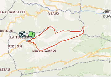
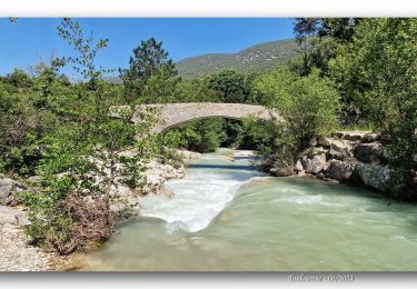
Tour Wandern von 13,6 km verfügbar auf Provence-Alpes-Côte d'Azur, Vaucluse, Beaumont-du-Ventoux. Diese Tour wird von MarcLEBARON vorgeschlagen.
Beschreibung
Boucle.
A éviter je suis passé par une propriété privée au départ, pour monter par la Combe d'Arnoux.
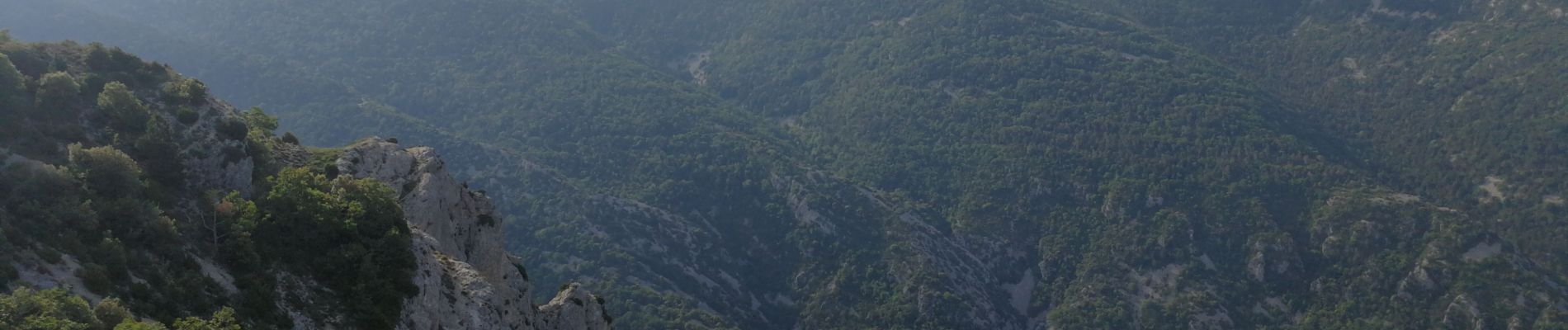
Crête agréable et sans difficulté, retour un peu laborieux sur le goudron.
Ort
Land:
France
Region :
Provence-Alpes-Côte d'Azur
Abteilung/Provinz :
Vaucluse
Kommune :
Beaumont-du-Ventoux
Standort:
Unknown
Gehen Sie:(Dec)
Gehen Sie:(UTM)
674211 ; 4895232 (31T) N.
Kommentare
Touren in der Umgebung
![Tour Wandern Entrechaux - Entrechaux en Vaucluse - Photo](https://media.geolcdn.com/t/375/260/ext.jpg?maxdim=2&url=https%3A%2F%2Fservices.sitytrail.com%2FGeolivesWS%2FDownloadMedia.ashx%3FTrailID%3D107158%26Media%3D12001_3.jpg)
![Wandern Wandern](https://static1.geolcdn.com/sitytour/trail-icons/101.png)
Entrechaux en Vaucluse
Wandern
Medium
(1)
Entrechaux,
Provence-Alpes-Côte d'Azur,
Vaucluse,
France
![](/images/other/stat-length.png)
9,5 km | 13,7 km-effort
2h 40min
![](https://static1.geolcdn.com/siteimages/upload/files/16400158638029165_repeat_loop_refresh_sync_direction_icon.png)
Ja
![Tour Wandern Beaumont-du-Ventoux - Ascension du Ventoux versant nord - Photo](https://media.geolcdn.com/t/375/260/22f53a61-90b8-424b-b027-8242692a4006.jpg&format=jpg&maxdim=2)
![Wandern Wandern](https://static1.geolcdn.com/sitytour/trail-icons/101.png)
Ascension du Ventoux versant nord
Wandern
Sehr schwierig
Beaumont-du-Ventoux,
Provence-Alpes-Côte d'Azur,
Vaucluse,
France
![](/images/other/stat-length.png)
24 km | 0 m-effort
7h 31min
![](https://static1.geolcdn.com/siteimages/upload/files/16400158638029165_repeat_loop_refresh_sync_direction_icon.png)
Ja
![Tour Wandern Malaucène - Campagne de Malaucène - Photo](https://media.geolcdn.com/t/375/260/ext.jpg?maxdim=2&url=https%3A%2F%2Fstatic1.geolcdn.com%2Fsiteimages%2Fupload%2Ffiles%2F1553511878bg_sport_marche.png)
![Wandern Wandern](https://static1.geolcdn.com/sitytour/trail-icons/101.png)
Campagne de Malaucène
Wandern
Einfach
(2)
Malaucène,
Provence-Alpes-Côte d'Azur,
Vaucluse,
France
![](/images/other/stat-length.png)
6,6 km | 8,1 km-effort
1h 30min
![](https://static1.geolcdn.com/siteimages/upload/files/16400158638029165_repeat_loop_refresh_sync_direction_icon.png)
Ja
![Tour Mountainbike Entrechaux - Tour de base VTT - Photo](https://media.geolcdn.com/t/375/260/ext.jpg?maxdim=2&url=https%3A%2F%2Fstatic1.geolcdn.com%2Fsiteimages%2Fupload%2Ffiles%2F1524743154velo.jpg)
![Mountainbike Mountainbike](https://static1.geolcdn.com/sitytour/trail-icons/202.png)
Tour de base VTT
Mountainbike
Sehr schwierig
(1)
Entrechaux,
Provence-Alpes-Côte d'Azur,
Vaucluse,
France
![](/images/other/stat-length.png)
19,2 km | 28 km-effort
Unbekannt
![](https://static1.geolcdn.com/siteimages/upload/files/16400158638029165_repeat_loop_refresh_sync_direction_icon.png)
Ja
![Tour Wandern Le Barroux - Les Barroux Pas du Loup - Photo](https://media.geolcdn.com/t/375/260/3c60b94c-6539-456f-b93b-bd62065998aa.jpg&format=jpg&maxdim=2)
![Wandern Wandern](https://static1.geolcdn.com/sitytour/trail-icons/101.png)
Les Barroux Pas du Loup
Wandern
Sehr schwierig
Le Barroux,
Provence-Alpes-Côte d'Azur,
Vaucluse,
France
![](/images/other/stat-length.png)
16,9 km | 26 km-effort
6h 38min
![](https://static1.geolcdn.com/siteimages/upload/files/16400158638029165_repeat_loop_refresh_sync_direction_icon.png)
Ja
![Tour Wandern Mollans-sur-Ouvèze - Canyon du Toulourenc 19.5.24 - Photo](https://media.geolcdn.com/t/375/260/fb32d0c7-83bc-4dd1-a780-422842c09078.jpg&format=jpg&maxdim=2)
![Wandern Wandern](https://static1.geolcdn.com/sitytour/trail-icons/101.png)
Canyon du Toulourenc 19.5.24
Wandern
Medium
Mollans-sur-Ouvèze,
Auvergne-Rhone-Alpen,
Drôme,
France
![](/images/other/stat-length.png)
10,5 km | 16,1 km-effort
3h 15min
![](https://static1.geolcdn.com/siteimages/upload/files/16400158638029165_repeat_loop_refresh_sync_direction_icon.png)
Ja
![Tour Wandern Malaucène - Autour de Malaucène - Photo](https://media.geolcdn.com/t/375/260/36981a6b-b22d-4dec-8acc-f103fc17d6c8.jpg&format=jpg&maxdim=2)
![Wandern Wandern](https://static1.geolcdn.com/sitytour/trail-icons/101.png)
Autour de Malaucène
Wandern
Schwierig
Malaucène,
Provence-Alpes-Côte d'Azur,
Vaucluse,
France
![](/images/other/stat-length.png)
18,3 km | 27 km-effort
5h 53min
![](https://static1.geolcdn.com/siteimages/upload/files/16400158638029165_repeat_loop_refresh_sync_direction_icon.png)
Ja
![Tour Wandern Malaucène - Malaucène - Photo](https://media.geolcdn.com/t/375/260/c33e34f2-52ee-44af-8dc1-c38fbc706e25.jpg&format=jpg&maxdim=2)
![Wandern Wandern](https://static1.geolcdn.com/sitytour/trail-icons/101.png)
Malaucène
Wandern
Sehr schwierig
Malaucène,
Provence-Alpes-Côte d'Azur,
Vaucluse,
France
![](/images/other/stat-length.png)
18,6 km | 27 km-effort
6h 32min
![](https://static1.geolcdn.com/siteimages/upload/files/16400158638029165_repeat_loop_refresh_sync_direction_icon.png)
Ja
![Tour Wandern Mollans-sur-Ouvèze - Le Toulourenc Via Veaux - Photo](https://media.geolcdn.com/t/375/260/a5d5ccc3-2089-4328-be8b-f2ad5ba6b8f0.jpg&format=jpg&maxdim=2)
![Wandern Wandern](https://static1.geolcdn.com/sitytour/trail-icons/101.png)
Le Toulourenc Via Veaux
Wandern
Schwierig
Mollans-sur-Ouvèze,
Auvergne-Rhone-Alpen,
Drôme,
France
![](/images/other/stat-length.png)
11,8 km | 17,8 km-effort
4h 2min
![](https://static1.geolcdn.com/siteimages/upload/files/16400158638029165_repeat_loop_refresh_sync_direction_icon.png)
Ja