![](/images/other/stat-length.png)
![Tour Wandern Aumessas - Gard - Aumessas Lac des Pises 17km 958m - Photo](https://media.geolcdn.com/t/1900/400/ext.pjpeg?maxdim=2&url=https%3A%2F%2Fstatic1.geolcdn.com%2Fsiteimages%2Fupload%2Ffiles%2F1553511878bg_sport_marche.png)
Gard - Aumessas Lac des Pises 17km 958m
RandoVal
Benutzer
![Länge](/images/other/stat-length.png)
Länge
16,7 km
![Maximale Höhe](https://static1.geolcdn.com/siteimages/upload/files/1508320355ic_sort_altitude_max_24dp.png)
Maximale Höhe
1332 m
![Positive Höhendifferenz](https://static1.geolcdn.com/siteimages/upload/files/1508320355ic_sort_den_pos_24dp.png)
Positive Höhendifferenz
975 m
![Km-Effort](/images/other/stat-length.png)
Km-Effort
30 km
![Min. Höhe](https://static1.geolcdn.com/siteimages/upload/files/1508320355ic_sort_altitude_min_24dp.png)
Min. Höhe
456 m
![Negative Höhendifferenz](https://static1.geolcdn.com/siteimages/upload/files/1508320355ic_sort_den_neg_24dp.png)
Negative Höhendifferenz
974 m
![Boucle](https://static1.geolcdn.com/siteimages/upload/files/16400158638029165_repeat_loop_refresh_sync_direction_icon.png)
Boucle
Ja
Erstellungsdatum :
2020-06-01 06:00:14.207
Letzte Änderung :
2020-06-01 16:51:03.141
![Wandern](https://static1.geolcdn.com/sitytour/trail-icons/101.png)
--
Schwierigkeit : Unbekannt
![Scannen Sie diesen QR-Code, um die Tour in der SityTrail-Anwendung zu öffnen](https://capi.geolives.com/qq0zvz2zws4bq2lad0pu/sitytour/trails/2420124/qr.png?size=200)
Kostenlosegpshiking-Anwendung
Über SityTrail
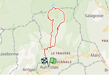
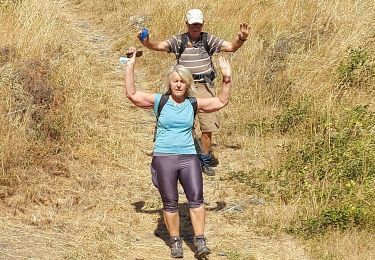
Tour Wandern von 16,7 km verfügbar auf Okzitanien, Gard, Aumessas. Diese Tour wird von RandoVal vorgeschlagen.
Beschreibung
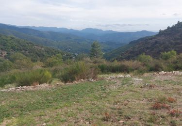
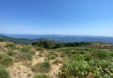
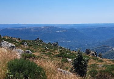
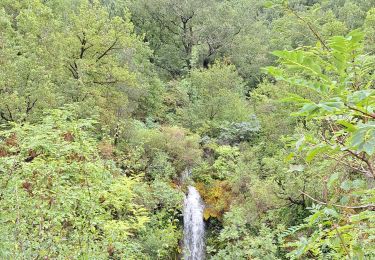
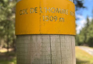
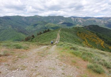
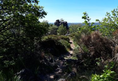
Rando en boucle au départ d'Aumessas vers le lac des Pises. Parking et départ sous les arbres sur l'ancienne voie ferrée, sens horaire. Belle Montée. Le pique-nique au bord du lac est cool. Au retour on fait la descente le long du torrent.
Ort
Land:
France
Region :
Okzitanien
Abteilung/Provinz :
Gard
Kommune :
Aumessas
Standort:
Unknown
Gehen Sie:(Dec)
Gehen Sie:(UTM)
540333 ; 4871014 (31T) N.
Kommentare
Touren in der Umgebung
![Tour Wandern Aumessas - Lac les Pisés départ Travers - Photo](https://media.geolcdn.com/t/375/260/ext.jpg?maxdim=2&url=https%3A%2F%2Fmedia.geolcdn.com%2Ff%2F679d267a-6a58-4423-871e-bc39638c17f2.jpg)
![Wandern Wandern](https://static1.geolcdn.com/sitytour/trail-icons/101.png)
Lac les Pisés départ Travers
Wandern
Sehr schwierig
Aumessas,
Okzitanien,
Gard,
France
![](/images/other/stat-length.png)
16,3 km | 27 km-effort
6h 35min
![](https://static1.geolcdn.com/siteimages/upload/files/16400158638029165_repeat_loop_refresh_sync_direction_icon.png)
Ja
![Tour Wandern Aumessas - Lac de Pises au départ Le Travers - Photo](https://media.geolcdn.com/t/375/260/ext.jpg?maxdim=2&url=https%3A%2F%2Fmedia.geolcdn.com%2Ff%2F2cc8f3c5-30d6-4002-a3b7-bac26a191665.jpg)
![Wandern Wandern](https://static1.geolcdn.com/sitytour/trail-icons/101.png)
Lac de Pises au départ Le Travers
Wandern
Schwierig
Aumessas,
Okzitanien,
Gard,
France
![](/images/other/stat-length.png)
16,7 km | 27 km-effort
7h 13min
![](https://static1.geolcdn.com/siteimages/upload/files/16400158638029165_repeat_loop_refresh_sync_direction_icon.png)
Ja
![Tour Wandern Arre - Vallée de l'Arre - Photo](https://media.geolcdn.com/t/375/260/ext.jpg?maxdim=2&url=https%3A%2F%2Fmedia.geolcdn.com%2Ff%2F0cd1e3db-2c3a-4247-99e2-3dd412bf8085.jpg)
![Wandern Wandern](https://static1.geolcdn.com/sitytour/trail-icons/101.png)
![Tour Wandern Arrigas - Col de l’Homme mort le Saint Guiral - Photo](https://media.geolcdn.com/t/375/260/ext.jpg?maxdim=2&url=https%3A%2F%2Fmedia.geolcdn.com%2Ff%2F261f46b4-fe0a-4f99-bec2-77703f139aba.jpg)
![Wandern Wandern](https://static1.geolcdn.com/sitytour/trail-icons/101.png)
Col de l’Homme mort le Saint Guiral
Wandern
Schwierig
Arrigas,
Okzitanien,
Gard,
France
![](/images/other/stat-length.png)
9,9 km | 13 km-effort
4h 11min
![](https://static1.geolcdn.com/siteimages/upload/files/16400158638029165_repeat_loop_refresh_sync_direction_icon.png)
Ja
![Tour Wandern Alzon - vers le St guiral puis le rocher de l'aigle - Photo](https://media.geolcdn.com/t/375/260/ext.jpg?maxdim=2&url=https%3A%2F%2Fmedia.geolcdn.com%2Ff%2Ff78318b9-9f52-40d1-b483-cd5ef15a47bd.jpg)
![Wandern Wandern](https://static1.geolcdn.com/sitytour/trail-icons/101.png)
vers le St guiral puis le rocher de l'aigle
Wandern
Schwierig
Alzon,
Okzitanien,
Gard,
France
![](/images/other/stat-length.png)
17,7 km | 29 km-effort
6h 51min
![](https://static1.geolcdn.com/siteimages/upload/files/16400158638029165_repeat_loop_refresh_sync_direction_icon.png)
Ja
![Tour Wandern Aumessas - Aumessas-27-05-21 - Photo](https://media.geolcdn.com/t/375/260/ext.jpg?maxdim=2&url=https%3A%2F%2Fmedia.geolcdn.com%2Ff%2Fd8457e82-6104-4bff-b3e1-ee1acbb884a6.jpg)
![Wandern Wandern](https://static1.geolcdn.com/sitytour/trail-icons/101.png)
Aumessas-27-05-21
Wandern
Medium
Aumessas,
Okzitanien,
Gard,
France
![](/images/other/stat-length.png)
11,8 km | 20 km-effort
4h 51min
![](https://static1.geolcdn.com/siteimages/upload/files/16400158638029165_repeat_loop_refresh_sync_direction_icon.png)
Ja
![Tour Wandern Arrigas - de Arrigas au Mont saint Guiral - Photo](https://media.geolcdn.com/t/375/260/ext.jpg?maxdim=2&url=https%3A%2F%2Fmedia.geolcdn.com%2Ff%2Fabd68f7f-1d05-4e6b-9849-9cfd8b8b8748.jpg)
![Wandern Wandern](https://static1.geolcdn.com/sitytour/trail-icons/101.png)
de Arrigas au Mont saint Guiral
Wandern
Medium
Arrigas,
Okzitanien,
Gard,
France
![](/images/other/stat-length.png)
22 km | 35 km-effort
5h 35min
![](https://static1.geolcdn.com/siteimages/upload/files/16400158638029165_repeat_loop_refresh_sync_direction_icon.png)
Ja
![Tour Wandern Alzon - Alzon-Cazebonne - Photo](https://media.geolcdn.com/t/375/260/ext.jpg?maxdim=2&url=https%3A%2F%2Fservices.sitytrail.com%2FGeolivesWS%2FDownloadMedia.ashx%3FTrailID%3D530734%26Media%3Dfix__20140529112428.jpg)
![Wandern Wandern](https://static1.geolcdn.com/sitytour/trail-icons/101.png)
Alzon-Cazebonne
Wandern
Einfach
Alzon,
Okzitanien,
Gard,
France
![](/images/other/stat-length.png)
10,7 km | 16,3 km-effort
3h 54min
![](https://static1.geolcdn.com/siteimages/upload/files/16400158638029165_repeat_loop_refresh_sync_direction_icon.png)
Ja
![Tour Wandern Alzon - Alzon-Cazebonne - Photo](https://media.geolcdn.com/t/375/260/ext.jpg?maxdim=2&url=https%3A%2F%2Fservices.sitytrail.com%2FGeolivesWS%2FDownloadMedia.ashx%3FTrailID%3D306909%26Media%3Dfix__20140529142742.jpg)
![Wandern Wandern](https://static1.geolcdn.com/sitytour/trail-icons/101.png)
Alzon-Cazebonne
Wandern
Einfach
Alzon,
Okzitanien,
Gard,
France
![](/images/other/stat-length.png)
10,7 km | 16,3 km-effort
3h 54min
![](https://static1.geolcdn.com/siteimages/upload/files/16400158638029165_repeat_loop_refresh_sync_direction_icon.png)
Ja