![](/images/other/stat-length.png)
![Tour Wandern Cabrespine - Cabrespine - Photo](https://media.geolcdn.com/t/1900/400/ext.pjpeg?maxdim=2&url=https%3A%2F%2Fstatic1.geolcdn.com%2Fsiteimages%2Fupload%2Ffiles%2F1553511878bg_sport_marche.png)
Cabrespine
SoleilMoussanais
Benutzer
![Länge](/images/other/stat-length.png)
Länge
10,8 km
![Maximale Höhe](https://static1.geolcdn.com/siteimages/upload/files/1508320355ic_sort_altitude_max_24dp.png)
Maximale Höhe
655 m
![Positive Höhendifferenz](https://static1.geolcdn.com/siteimages/upload/files/1508320355ic_sort_den_pos_24dp.png)
Positive Höhendifferenz
420 m
![Km-Effort](/images/other/stat-length.png)
Km-Effort
16,4 km
![Min. Höhe](https://static1.geolcdn.com/siteimages/upload/files/1508320355ic_sort_altitude_min_24dp.png)
Min. Höhe
302 m
![Negative Höhendifferenz](https://static1.geolcdn.com/siteimages/upload/files/1508320355ic_sort_den_neg_24dp.png)
Negative Höhendifferenz
418 m
![Boucle](https://static1.geolcdn.com/siteimages/upload/files/16400158638029165_repeat_loop_refresh_sync_direction_icon.png)
Boucle
Ja
Erstellungsdatum :
2020-05-26 08:18:47.711
Letzte Änderung :
2020-05-26 15:38:28.575
![Wandern](https://static1.geolcdn.com/sitytour/trail-icons/101.png)
5h35
Schwierigkeit : Sehr leicht
![Scannen Sie diesen QR-Code, um die Tour in der SityTrail-Anwendung zu öffnen](https://capi.geolives.com/qq0zvz2zws4bq2lad0pu/sitytour/trails/2412030/qr.png?size=200)
Kostenlosegpshiking-Anwendung
Über SityTrail
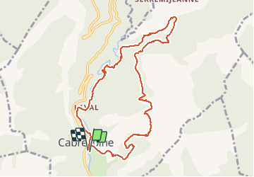
Tour Wandern von 10,8 km verfügbar auf Okzitanien, Aude, Cabrespine. Diese Tour wird von SoleilMoussanais vorgeschlagen.
Beschreibung
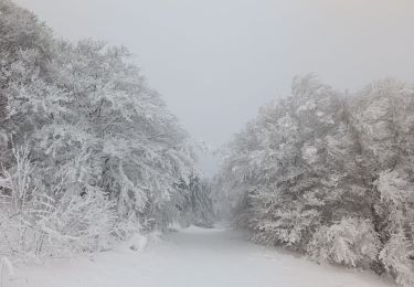
Les pas de l'aube. Randonnée de difficulté moyenne. Plus grande partie sous bois. Ruisseaux à traverser mais sans grande difficulté en mai,juin.
Ort
Land:
France
Region :
Okzitanien
Abteilung/Provinz :
Aude
Kommune :
Cabrespine
Standort:
Unknown
Gehen Sie:(Dec)
Gehen Sie:(UTM)
456327 ; 4801108 (31T) N.
Kommentare
Touren in der Umgebung
![Tour Zu Fuß Cabrespine - Les Villages Perchés - Photo](https://media.geolcdn.com/t/375/260/4379f8e7-e0a2-4ee4-810f-0aa42c1f51f8.jpeg&format=jpg&maxdim=2)
![Zu Fuß Zu Fuß](https://static1.geolcdn.com/sitytour/trail-icons/100.png)
Les Villages Perchés
Zu Fuß
Einfach
Cabrespine,
Okzitanien,
Aude,
France
![](/images/other/stat-length.png)
8,3 km | 14,7 km-effort
3h 21min
![](https://static1.geolcdn.com/siteimages/upload/files/16400158638029165_repeat_loop_refresh_sync_direction_icon.png)
Nein
![Tour Zu Fuß Cabrespine - Boucle du Gouffre de Cabrespine - Photo](https://media.geolcdn.com/t/375/260/b4f79f08-71e0-4997-b690-a17cfd5f244e.jpeg&format=jpg&maxdim=2)
![Zu Fuß Zu Fuß](https://static1.geolcdn.com/sitytour/trail-icons/100.png)
Boucle du Gouffre de Cabrespine
Zu Fuß
Einfach
Cabrespine,
Okzitanien,
Aude,
France
![](/images/other/stat-length.png)
4,9 km | 8,7 km-effort
1h 59min
![](https://static1.geolcdn.com/siteimages/upload/files/16400158638029165_repeat_loop_refresh_sync_direction_icon.png)
Nein
![Tour Wandern Villeneuve-Minervois - pujol de bosc castanviel - Photo](https://media.geolcdn.com/t/375/260/0e58840e-6e19-4149-b133-b9ac43c459d6.jpg&format=jpg&maxdim=2)
![Wandern Wandern](https://static1.geolcdn.com/sitytour/trail-icons/101.png)
pujol de bosc castanviel
Wandern
Einfach
Villeneuve-Minervois,
Okzitanien,
Aude,
France
![](/images/other/stat-length.png)
15,9 km | 23 km-effort
5h 20min
![](https://static1.geolcdn.com/siteimages/upload/files/16400158638029165_repeat_loop_refresh_sync_direction_icon.png)
Ja
![Tour Wandern Sallèles-Cabardès - Sallèles Cabardès - Pradellles Cabardès - Pic du Nore- - Photo](https://media.geolcdn.com/t/375/260/90caa0b8-22c4-41a8-a0b4-9f5599ac34e4.jpg&format=jpg&maxdim=2)
![Wandern Wandern](https://static1.geolcdn.com/sitytour/trail-icons/101.png)
Sallèles Cabardès - Pradellles Cabardès - Pic du Nore-
Wandern
Sehr schwierig
Sallèles-Cabardès,
Okzitanien,
Aude,
France
![](/images/other/stat-length.png)
65 km | 0 m-effort
23h 36min
![](https://static1.geolcdn.com/siteimages/upload/files/16400158638029165_repeat_loop_refresh_sync_direction_icon.png)
Ja
![Tour Wandern Sallèles-Cabardès - Reco Le Pic de Nore - Photo](https://media.geolcdn.com/t/375/260/81a42295-0bf8-4918-a48c-4464e99ea34e.jpg&format=jpg&maxdim=2)
![Wandern Wandern](https://static1.geolcdn.com/sitytour/trail-icons/101.png)
Reco Le Pic de Nore
Wandern
Sehr schwierig
Sallèles-Cabardès,
Okzitanien,
Aude,
France
![](/images/other/stat-length.png)
54 km | 79 km-effort
21h 27min
![](https://static1.geolcdn.com/siteimages/upload/files/16400158638029165_repeat_loop_refresh_sync_direction_icon.png)
Ja
![Tour Wandern Limousis - Limousis - Photo](https://media.geolcdn.com/t/375/260/c9382851-66d8-4f11-8490-1b66e63d0ad4.jpg&format=jpg&maxdim=2)
![Wandern Wandern](https://static1.geolcdn.com/sitytour/trail-icons/101.png)
![Tour Wandern Limousis - Mont Simel - Photo](https://media.geolcdn.com/t/375/260/38332c18-c5e2-4493-b4a7-4fa8f48f76d3.jpg&format=jpg&maxdim=2)
![Wandern Wandern](https://static1.geolcdn.com/sitytour/trail-icons/101.png)
![Tour Zu Fuß Pradelles-Cabardès - Pradelles,roc de l'aigle,cabrespine,pradelles - Photo](https://media.geolcdn.com/t/375/260/82fe34a8-bde4-49e0-8e94-332d7cbba6cc.jpg&format=jpg&maxdim=2)
![Zu Fuß Zu Fuß](https://static1.geolcdn.com/sitytour/trail-icons/100.png)
Pradelles,roc de l'aigle,cabrespine,pradelles
Zu Fuß
Schwierig
Pradelles-Cabardès,
Okzitanien,
Aude,
France
![](/images/other/stat-length.png)
15,3 km | 24 km-effort
5h 50min
![](https://static1.geolcdn.com/siteimages/upload/files/16400158638029165_repeat_loop_refresh_sync_direction_icon.png)
Ja
![Tour Wandern Trassanel - trassanel gorges d'Escole RF - Photo](https://media.geolcdn.com/t/375/260/ext.jpg?maxdim=2&url=https%3A%2F%2Fstatic1.geolcdn.com%2Fsiteimages%2Fupload%2Ffiles%2F1553511878bg_sport_marche.png)
![Wandern Wandern](https://static1.geolcdn.com/sitytour/trail-icons/101.png)
trassanel gorges d'Escole RF
Wandern
Medium
(1)
Trassanel,
Okzitanien,
Aude,
France
![](/images/other/stat-length.png)
8,7 km | 11,7 km-effort
3h 2min
![](https://static1.geolcdn.com/siteimages/upload/files/16400158638029165_repeat_loop_refresh_sync_direction_icon.png)
Ja