![](/images/other/stat-length.png)
![Tour Andere Aktivitäten Assens - Chalet-à-Gobet / Assens - Photo](https://media.geolcdn.com/t/1900/400/ext.pjpeg?maxdim=2&url=https%3A%2F%2Fstatic1.geolcdn.com%2Fsiteimages%2Fupload%2Ffiles%2F1545311037marcheuse_200dpi.jpg)
Chalet-à-Gobet / Assens
FELIXRN
Benutzer
![Länge](/images/other/stat-length.png)
Länge
21 km
![Maximale Höhe](https://static1.geolcdn.com/siteimages/upload/files/1508320355ic_sort_altitude_max_24dp.png)
Maximale Höhe
936 m
![Positive Höhendifferenz](https://static1.geolcdn.com/siteimages/upload/files/1508320355ic_sort_den_pos_24dp.png)
Positive Höhendifferenz
638 m
![Km-Effort](/images/other/stat-length.png)
Km-Effort
30 km
![Min. Höhe](https://static1.geolcdn.com/siteimages/upload/files/1508320355ic_sort_altitude_min_24dp.png)
Min. Höhe
612 m
![Negative Höhendifferenz](https://static1.geolcdn.com/siteimages/upload/files/1508320355ic_sort_den_neg_24dp.png)
Negative Höhendifferenz
639 m
![Boucle](https://static1.geolcdn.com/siteimages/upload/files/16400158638029165_repeat_loop_refresh_sync_direction_icon.png)
Boucle
Nein
Erstellungsdatum :
2014-12-11 00:00:00.0
Letzte Änderung :
2014-12-11 00:00:00.0
![Andere Aktivitäten](https://static1.geolcdn.com/sitytour/trail-icons/900.png)
--
Schwierigkeit : Unbekannt
![Scannen Sie diesen QR-Code, um die Tour in der SityTrail-Anwendung zu öffnen](https://capi.geolives.com/qq0zvz2zws4bq2lad0pu/sitytour/trails/24080/qr.png?size=200)
Kostenlosegpshiking-Anwendung
Über SityTrail
Tour Andere Aktivitäten von 21 km verfügbar auf Waadt, District du Gros-de-Vaud, Assens. Diese Tour wird von FELIXRN vorgeschlagen.
Beschreibung
Selon "Randonnées en suisse romande", ballade 31.
Ort
Land:
Switzerland
Region :
Waadt
Abteilung/Provinz :
District du Gros-de-Vaud
Kommune :
Assens
Standort:
Unknown
Gehen Sie:(Dec)
Gehen Sie:(UTM)
317689 ; 5164999 (32T) N.
Kommentare
Touren in der Umgebung
![Tour Wintersport Morrens - Au boulot à ski, aller-retour, déc 2009 - Photo](https://media.geolcdn.com/t/375/260/ext.jpg?maxdim=2&url=https%3A%2F%2Fservices.sitytrail.com%2FGeolivesWS%2FDownloadMedia.ashx%3FTrailID%3D30582%26Media%3Dimage2.JPG)
![Wintersport Wintersport](https://static1.geolcdn.com/sitytour/trail-icons/500.png)
Au boulot à ski, aller-retour, déc 2009
Wintersport
Sehr leicht
Morrens,
Waadt,
District du Gros-de-Vaud,
Switzerland
![](/images/other/stat-length.png)
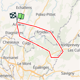
16,3 km | 21 km-effort
3h 0min
![](https://static1.geolcdn.com/siteimages/upload/files/16400158638029165_repeat_loop_refresh_sync_direction_icon.png)
Ja
![Tour Wandern Mex (VD) - Les Esserts - Bois Bahud - Photo](https://media.geolcdn.com/t/375/260/ext.jpg?maxdim=2&url=https%3A%2F%2Fstatic1.geolcdn.com%2Fsiteimages%2Fupload%2Ffiles%2F1553511878bg_sport_marche.png)
![Wandern Wandern](https://static1.geolcdn.com/sitytour/trail-icons/101.png)
Les Esserts - Bois Bahud
Wandern
Medium
Mex (VD),
Waadt,
District du Gros-de-Vaud,
Switzerland
![](/images/other/stat-length.png)
4,5 km | 6 km-effort
1h 22min
![](https://static1.geolcdn.com/siteimages/upload/files/16400158638029165_repeat_loop_refresh_sync_direction_icon.png)
Ja
![Tour Andere Aktivitäten Le Mont-sur-Lausanne - Cadev - Photo](https://media.geolcdn.com/t/375/260/ext.jpg?maxdim=2&url=https%3A%2F%2Fstatic1.geolcdn.com%2Fsiteimages%2Fupload%2Ffiles%2F1545311037marcheuse_200dpi.jpg)
![Andere Aktivitäten Andere Aktivitäten](https://static1.geolcdn.com/sitytour/trail-icons/900.png)
Cadev
Andere Aktivitäten
Sehr leicht
Le Mont-sur-Lausanne,
Waadt,
District de Lausanne,
Switzerland
![](/images/other/stat-length.png)
4,2 km | 5,7 km-effort
Unbekannt
![](https://static1.geolcdn.com/siteimages/upload/files/16400158638029165_repeat_loop_refresh_sync_direction_icon.png)
Nein
![Tour Andere Aktivitäten Morrens - morrens - Photo](https://media.geolcdn.com/t/375/260/ext.jpg?maxdim=2&url=https%3A%2F%2Fstatic1.geolcdn.com%2Fsiteimages%2Fupload%2Ffiles%2F1545311037marcheuse_200dpi.jpg)
![Andere Aktivitäten Andere Aktivitäten](https://static1.geolcdn.com/sitytour/trail-icons/900.png)
morrens
Andere Aktivitäten
Sehr leicht
Morrens,
Waadt,
District du Gros-de-Vaud,
Switzerland
![](/images/other/stat-length.png)
7,2 km | 9 km-effort
Unbekannt
![](https://static1.geolcdn.com/siteimages/upload/files/16400158638029165_repeat_loop_refresh_sync_direction_icon.png)
Ja
![Tour Andere Aktivitäten Bottens - bottens - Photo](https://media.geolcdn.com/t/375/260/ext.jpg?maxdim=2&url=https%3A%2F%2Fstatic1.geolcdn.com%2Fsiteimages%2Fupload%2Ffiles%2F1545311037marcheuse_200dpi.jpg)
![Andere Aktivitäten Andere Aktivitäten](https://static1.geolcdn.com/sitytour/trail-icons/900.png)
bottens
Andere Aktivitäten
Sehr leicht
Bottens,
Waadt,
District du Gros-de-Vaud,
Switzerland
![](/images/other/stat-length.png)
7 km | 8,6 km-effort
Unbekannt
![](https://static1.geolcdn.com/siteimages/upload/files/16400158638029165_repeat_loop_refresh_sync_direction_icon.png)
Ja
![Tour Andere Aktivitäten Eclépens - canal entreroches - Photo](https://media.geolcdn.com/t/375/260/ext.jpg?maxdim=2&url=https%3A%2F%2Fstatic1.geolcdn.com%2Fsiteimages%2Fupload%2Ffiles%2F1545311037marcheuse_200dpi.jpg)
![Andere Aktivitäten Andere Aktivitäten](https://static1.geolcdn.com/sitytour/trail-icons/900.png)
canal entreroches
Andere Aktivitäten
Sehr leicht
Eclépens,
Waadt,
District de Morges,
Switzerland
![](/images/other/stat-length.png)
4,1 km | 5,7 km-effort
Unbekannt
![](https://static1.geolcdn.com/siteimages/upload/files/16400158638029165_repeat_loop_refresh_sync_direction_icon.png)
Nein
![Tour Wandern Echallens - Le Chemin des Blés - Photo](https://media.geolcdn.com/t/375/260/ext.jpg?maxdim=2&url=https%3A%2F%2Fstatic1.geolcdn.com%2Fsiteimages%2Fupload%2Ffiles%2F1553511878bg_sport_marche.png)
![Wandern Wandern](https://static1.geolcdn.com/sitytour/trail-icons/101.png)
Le Chemin des Blés
Wandern
Sehr leicht
Echallens,
Waadt,
District du Gros-de-Vaud,
Switzerland
![](/images/other/stat-length.png)
86 km | 112 km-effort
18h 25min
![](https://static1.geolcdn.com/siteimages/upload/files/16400158638029165_repeat_loop_refresh_sync_direction_icon.png)
Ja
![Tour Andere Aktivitäten Sullens - Training Intervall - Photo](https://media.geolcdn.com/t/375/260/ext.jpg?maxdim=2&url=https%3A%2F%2Fstatic1.geolcdn.com%2Fsiteimages%2Fupload%2Ffiles%2F1545311037marcheuse_200dpi.jpg)
![Andere Aktivitäten Andere Aktivitäten](https://static1.geolcdn.com/sitytour/trail-icons/900.png)
Training Intervall
Andere Aktivitäten
Sehr leicht
Sullens,
Waadt,
District du Gros-de-Vaud,
Switzerland
![](/images/other/stat-length.png)
10,3 km | 11,6 km-effort
Unbekannt
![](https://static1.geolcdn.com/siteimages/upload/files/16400158638029165_repeat_loop_refresh_sync_direction_icon.png)
Ja
![Tour Andere Aktivitäten Cugy - Cugy - Photo](https://media.geolcdn.com/t/375/260/ext.jpg?maxdim=2&url=https%3A%2F%2Fstatic1.geolcdn.com%2Fsiteimages%2Fupload%2Ffiles%2F1545311037marcheuse_200dpi.jpg)
![Andere Aktivitäten Andere Aktivitäten](https://static1.geolcdn.com/sitytour/trail-icons/900.png)
Cugy
Andere Aktivitäten
Sehr leicht
Cugy,
Waadt,
District du Gros-de-Vaud,
Switzerland
![](/images/other/stat-length.png)
7,8 km | 10,1 km-effort
Unbekannt
![](https://static1.geolcdn.com/siteimages/upload/files/16400158638029165_repeat_loop_refresh_sync_direction_icon.png)
Ja