![](/images/other/stat-length.png)
![Tour Wandern Itteville - 2020-05-23 itteville Baulne 17 km - Photo](https://media.geolcdn.com/t/1900/400/c61004ad-47b3-4c4d-9e92-627885ca470a.jpg&format=pjpeg&maxdim=2)
2020-05-23 itteville Baulne 17 km
Lucquiaud
Benutzer
![Länge](/images/other/stat-length.png)
![Maximale Höhe](https://static1.geolcdn.com/siteimages/upload/files/1508320355ic_sort_altitude_max_24dp.png)
![Positive Höhendifferenz](https://static1.geolcdn.com/siteimages/upload/files/1508320355ic_sort_den_pos_24dp.png)
![Km-Effort](/images/other/stat-length.png)
![Min. Höhe](https://static1.geolcdn.com/siteimages/upload/files/1508320355ic_sort_altitude_min_24dp.png)
![Negative Höhendifferenz](https://static1.geolcdn.com/siteimages/upload/files/1508320355ic_sort_den_neg_24dp.png)
![Boucle](https://static1.geolcdn.com/siteimages/upload/files/16400158638029165_repeat_loop_refresh_sync_direction_icon.png)
![Wandern](https://static1.geolcdn.com/sitytour/trail-icons/101.png)
5h38
Schwierigkeit : Medium
![Scannen Sie diesen QR-Code, um die Tour in der SityTrail-Anwendung zu öffnen](https://capi.geolives.com/qq0zvz2zws4bq2lad0pu/sitytour/trails/2407682/qr.png?size=200)
Kostenlosegpshiking-Anwendung
Über SityTrail
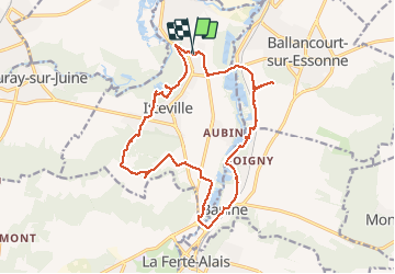
Tour Wandern von 17,7 km verfügbar auf Île-de-France, Essonne, Itteville. Diese Tour wird von Lucquiaud vorgeschlagen.
Beschreibung
Départ du haut d'Itteville, passage par le chemin de l'Avau pour aller aux 3 observatoires des marais.
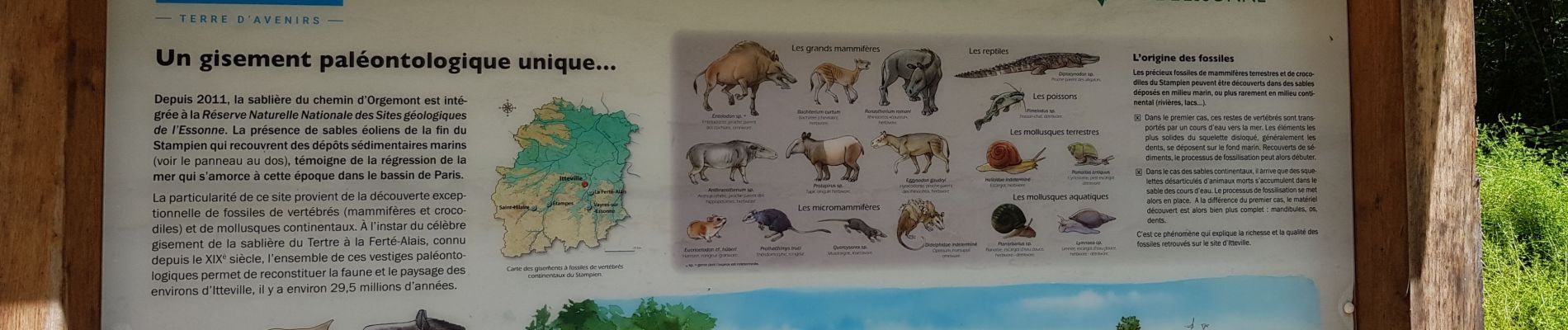
Remontée par la sablière d'Orgemont (site archéologique du scampien).
Vue sur la piste en herbe de l'aérodrome de Cerny/la Ferté Allais.
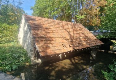
Descente vers Cerny , traversée de l'Essonne par le moulin du Gué aux Moulins Fauché (produisant la farine des baguettes l'Essonnienne), propriété privée, accessible le WE ?,
Passage par les étangs de Baulne entre les pavillons ou cabanons de pêche et autre passe-temps .
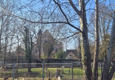
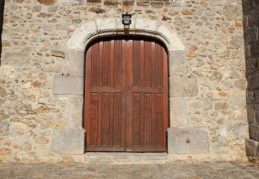
Arrêt à l'ancienne chapelle des Templiers Saint Blaise, détour possible pour voir l'entrée du château de Saussay à Ballancourt (où ont été tournées des scènes de films connus).
Traversée de nouveau de la ligne RER D et de l'Essonne près d'un ancien moulin.
Retour sur le haut d'Itteville.
Ort
Kommentare
Touren in der Umgebung
![Tour Wandern Marolles-en-Hurepoix - Marolles Lardy Bouray St Vrain - Photo](https://media.geolcdn.com/t/375/260/33c381bd-a07a-4eb0-86bc-485e818428bf.jpg&format=jpg&maxdim=2)
![Wandern Wandern](https://static1.geolcdn.com/sitytour/trail-icons/101.png)
Wandern
![](/images/other/stat-length.png)
![](https://static1.geolcdn.com/siteimages/upload/files/16400158638029165_repeat_loop_refresh_sync_direction_icon.png)
![Tour Wandern Itteville - Les vieilles ailes - Photo](https://media.geolcdn.com/t/375/260/401f9abb-572c-45de-a602-03e6caf0f1c1.jpg&format=jpg&maxdim=2)
![Wandern Wandern](https://static1.geolcdn.com/sitytour/trail-icons/101.png)
Wandern
![](/images/other/stat-length.png)
![](https://static1.geolcdn.com/siteimages/upload/files/16400158638029165_repeat_loop_refresh_sync_direction_icon.png)
![Tour Mountainbike Lardy - Autour de Lardy en VTT - Photo](https://media.geolcdn.com/t/375/260/ext.jpg?maxdim=2&url=https%3A%2F%2Fservices.sitytrail.com%2FGeolivesWS%2FDownloadMedia.ashx%3FTrailID%3D104079%26Media%3D7075_1.jpg)
![Mountainbike Mountainbike](https://static1.geolcdn.com/sitytour/trail-icons/202.png)
Mountainbike
![](/images/other/stat-length.png)
![](https://static1.geolcdn.com/siteimages/upload/files/16400158638029165_repeat_loop_refresh_sync_direction_icon.png)
![Tour Wandern Ballancourt-sur-Essonne - Rando Ballancourt 15 km BM - Photo](https://media.geolcdn.com/t/375/260/8977c33c-1145-4a4f-97a7-a064e00deb0b.jpg&format=jpg&maxdim=2)
![Wandern Wandern](https://static1.geolcdn.com/sitytour/trail-icons/101.png)
Wandern
![](/images/other/stat-length.png)
![](https://static1.geolcdn.com/siteimages/upload/files/16400158638029165_repeat_loop_refresh_sync_direction_icon.png)
![Tour Wandern Ballancourt-sur-Essonne - Boucle autour de Ballancourt - Photo](https://media.geolcdn.com/t/375/260/726c3226-57e6-4792-b7bd-15745463bf1c.jpg&format=jpg&maxdim=2)
![Wandern Wandern](https://static1.geolcdn.com/sitytour/trail-icons/101.png)
Wandern
![](/images/other/stat-length.png)
![](https://static1.geolcdn.com/siteimages/upload/files/16400158638029165_repeat_loop_refresh_sync_direction_icon.png)
![Tour Wandern Baulne - De La Ferté Alais à Mennecy - Photo](https://media.geolcdn.com/t/375/260/8fe2ded9-b4df-4cf6-bfbe-cc2b96524a28.jpg&format=jpg&maxdim=2)
![Wandern Wandern](https://static1.geolcdn.com/sitytour/trail-icons/101.png)
Wandern
![](/images/other/stat-length.png)
![](https://static1.geolcdn.com/siteimages/upload/files/16400158638029165_repeat_loop_refresh_sync_direction_icon.png)
![Tour Zu Fuß Itteville - SityTrail - 3212203 - itteville - Photo](https://media.geolcdn.com/t/375/260/56ba6227-1e0d-415b-8a48-77e4f7fc1956.jpg&format=jpg&maxdim=2)
![Zu Fuß Zu Fuß](https://static1.geolcdn.com/sitytour/trail-icons/100.png)
Zu Fuß
![](/images/other/stat-length.png)
![](https://static1.geolcdn.com/siteimages/upload/files/16400158638029165_repeat_loop_refresh_sync_direction_icon.png)
![Tour Zu Fuß La Ferté-Alais - Boucle Orveau - Ferté Alais 27 km - Photo](https://media.geolcdn.com/t/375/260/7e0587a3-b381-4c51-bb59-08cb2434ad69.jpg&format=jpg&maxdim=2)
![Zu Fuß Zu Fuß](https://static1.geolcdn.com/sitytour/trail-icons/100.png)
Zu Fuß
![](/images/other/stat-length.png)
![](https://static1.geolcdn.com/siteimages/upload/files/16400158638029165_repeat_loop_refresh_sync_direction_icon.png)
![Tour Zu Fuß Itteville - Chemin des Marais - Photo](https://media.geolcdn.com/t/375/260/6ec12119-ce61-4685-a08a-304ea362f94a.jpeg&format=jpg&maxdim=2)
![Zu Fuß Zu Fuß](https://static1.geolcdn.com/sitytour/trail-icons/100.png)
Zu Fuß
![](/images/other/stat-length.png)
![](https://static1.geolcdn.com/siteimages/upload/files/16400158638029165_repeat_loop_refresh_sync_direction_icon.png)