![](/images/other/stat-length.png)
![Tour Andere Aktivitäten Frick - Frick - Photo](https://media.geolcdn.com/t/1900/400/ext.pjpeg?maxdim=2&url=https%3A%2F%2Fstatic1.geolcdn.com%2Fsiteimages%2Fupload%2Ffiles%2F1545311037marcheuse_200dpi.jpg)
Frick
hrb
Benutzer
![Länge](/images/other/stat-length.png)
Länge
14,6 km
![Maximale Höhe](https://static1.geolcdn.com/siteimages/upload/files/1508320355ic_sort_altitude_max_24dp.png)
Maximale Höhe
717 m
![Positive Höhendifferenz](https://static1.geolcdn.com/siteimages/upload/files/1508320355ic_sort_den_pos_24dp.png)
Positive Höhendifferenz
565 m
![Km-Effort](/images/other/stat-length.png)
Km-Effort
22 km
![Min. Höhe](https://static1.geolcdn.com/siteimages/upload/files/1508320355ic_sort_altitude_min_24dp.png)
Min. Höhe
342 m
![Negative Höhendifferenz](https://static1.geolcdn.com/siteimages/upload/files/1508320355ic_sort_den_neg_24dp.png)
Negative Höhendifferenz
383 m
![Boucle](https://static1.geolcdn.com/siteimages/upload/files/16400158638029165_repeat_loop_refresh_sync_direction_icon.png)
Boucle
Nein
Erstellungsdatum :
2014-12-11 00:00:00.0
Letzte Änderung :
2014-12-11 00:00:00.0
![Andere Aktivitäten](https://static1.geolcdn.com/sitytour/trail-icons/900.png)
--
Schwierigkeit : Unbekannt
![Scannen Sie diesen QR-Code, um die Tour in der SityTrail-Anwendung zu öffnen](https://capi.geolives.com/qq0zvz2zws4bq2lad0pu/sitytour/trails/23965/qr.png?size=200)
Kostenlosegpshiking-Anwendung
Über SityTrail
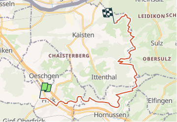
Tour Andere Aktivitäten von 14,6 km verfügbar auf Aargau, Bezirk Laufenburg, Frick. Diese Tour wird von hrb vorgeschlagen.
Beschreibung
Ursprünglich war die Wanderung länger, aber die Wege entlang der Menthue waren saumässig verwildert!
Achtung: die Brücke bei Bois Dessous existierte am 2.05.2008 nicht mehr.
Ort
Land:
Switzerland
Region :
Aargau
Abteilung/Provinz :
Bezirk Laufenburg
Kommune :
Frick
Standort:
Unknown
Gehen Sie:(Dec)
Gehen Sie:(UTM)
425783 ; 5262120 (32T) N.
Kommentare
Touren in der Umgebung
![Tour Zu Fuß Stein - Mumpf - Stein - Photo](https://media.geolcdn.com/t/375/260/ext.jpg?maxdim=2&url=https%3A%2F%2Fmedia.geolcdn.com%2Ff%2F329376f5-0142-481b-b287-5775a241a7bd.jpeg)
![Zu Fuß Zu Fuß](https://static1.geolcdn.com/sitytour/trail-icons/100.png)
Mumpf - Stein
Zu Fuß
Einfach
Stein,
Aargau,
Bezirk Rheinfelden,
Switzerland
![](/images/other/stat-length.png)
3,4 km | 3,8 km-effort
52min
![](https://static1.geolcdn.com/siteimages/upload/files/16400158638029165_repeat_loop_refresh_sync_direction_icon.png)
Nein
![Tour Zu Fuß Sisseln - Eiken - Sisseln - Photo](https://media.geolcdn.com/t/375/260/ext.jpg?maxdim=2&url=https%3A%2F%2Fmedia.geolcdn.com%2Ff%2Ff6f962f9-4f62-4c94-9e33-68190dd25ed5.jpeg)
![Zu Fuß Zu Fuß](https://static1.geolcdn.com/sitytour/trail-icons/100.png)
Eiken - Sisseln
Zu Fuß
Einfach
Sisseln,
Aargau,
Bezirk Laufenburg,
Switzerland
![](/images/other/stat-length.png)
3,1 km | 3,9 km-effort
52min
![](https://static1.geolcdn.com/siteimages/upload/files/16400158638029165_repeat_loop_refresh_sync_direction_icon.png)
Nein
![Tour Zu Fuß Frick - Frick - Oeschgen - Photo](https://media.geolcdn.com/t/375/260/ext.jpg?maxdim=2&url=https%3A%2F%2Fmedia.geolcdn.com%2Ff%2Fdev_4459ec54-e78f-499d-a597-ee88cf25b2c2.jpeg)
![Zu Fuß Zu Fuß](https://static1.geolcdn.com/sitytour/trail-icons/100.png)
Frick - Oeschgen
Zu Fuß
Einfach
Frick,
Aargau,
Bezirk Laufenburg,
Switzerland
![](/images/other/stat-length.png)
3,1 km | 3,6 km-effort
49min
![](https://static1.geolcdn.com/siteimages/upload/files/16400158638029165_repeat_loop_refresh_sync_direction_icon.png)
Nein
![Tour Zu Fuß Frick - Frick - Junkholz - Photo](https://media.geolcdn.com/t/375/260/ext.jpg?maxdim=2&url=https%3A%2F%2Fmedia.geolcdn.com%2Ff%2Fdev_4459ec54-e78f-499d-a597-ee88cf25b2c2.jpeg)
![Zu Fuß Zu Fuß](https://static1.geolcdn.com/sitytour/trail-icons/100.png)
Frick - Junkholz
Zu Fuß
Einfach
Frick,
Aargau,
Bezirk Laufenburg,
Switzerland
![](/images/other/stat-length.png)
5,5 km | 7,7 km-effort
1h 44min
![](https://static1.geolcdn.com/siteimages/upload/files/16400158638029165_repeat_loop_refresh_sync_direction_icon.png)
Nein
![Tour Zu Fuß Kaisten - Ittenthal - Frick - Photo](https://media.geolcdn.com/t/375/260/ext.jpg?maxdim=2&url=https%3A%2F%2Fmedia.geolcdn.com%2Ff%2Fdev_29b0417c-ec28-4965-b980-955f927d61da.jpeg)
![Zu Fuß Zu Fuß](https://static1.geolcdn.com/sitytour/trail-icons/100.png)
Ittenthal - Frick
Zu Fuß
Einfach
Kaisten,
Aargau,
Bezirk Laufenburg,
Switzerland
![](/images/other/stat-length.png)
5,6 km | 8,3 km-effort
1h 53min
![](https://static1.geolcdn.com/siteimages/upload/files/16400158638029165_repeat_loop_refresh_sync_direction_icon.png)
Nein
![Tour Zu Fuß Stein - Schupfart - Stein - Photo](https://media.geolcdn.com/t/375/260/ext.jpg?maxdim=2&url=https%3A%2F%2Fmedia.geolcdn.com%2Ff%2Ff7b1dfe4-57b5-4c99-8b86-f96b1e2ff156.jpeg)
![Zu Fuß Zu Fuß](https://static1.geolcdn.com/sitytour/trail-icons/100.png)
Schupfart - Stein
Zu Fuß
Einfach
Stein,
Aargau,
Bezirk Rheinfelden,
Switzerland
![](/images/other/stat-length.png)
4,5 km | 6,8 km-effort
1h 32min
![](https://static1.geolcdn.com/siteimages/upload/files/16400158638029165_repeat_loop_refresh_sync_direction_icon.png)
Nein
![Tour Zu Fuß Frick - Frick - Ruine Tierstein - Photo](https://media.geolcdn.com/t/375/260/ext.jpg?maxdim=2&url=https%3A%2F%2Fmedia.geolcdn.com%2Ff%2Fdev_4459ec54-e78f-499d-a597-ee88cf25b2c2.jpeg)
![Zu Fuß Zu Fuß](https://static1.geolcdn.com/sitytour/trail-icons/100.png)
Frick - Ruine Tierstein
Zu Fuß
Einfach
Frick,
Aargau,
Bezirk Laufenburg,
Switzerland
![](/images/other/stat-length.png)
4,9 km | 8 km-effort
1h 49min
![](https://static1.geolcdn.com/siteimages/upload/files/16400158638029165_repeat_loop_refresh_sync_direction_icon.png)
Nein
![Tour Zu Fuß Herznach - fixme - fixme - Photo](https://media.geolcdn.com/t/375/260/ext.jpg?maxdim=2&url=https%3A%2F%2Fmedia.geolcdn.com%2Ff%2Fccbe76e3-4b0b-4cf8-921b-1aa93c0437b1.jpeg)
![Zu Fuß Zu Fuß](https://static1.geolcdn.com/sitytour/trail-icons/100.png)
fixme - fixme
Zu Fuß
Einfach
Herznach,
Aargau,
Bezirk Laufenburg,
Switzerland
![](/images/other/stat-length.png)
4 km | 5,3 km-effort
1h 12min
![](https://static1.geolcdn.com/siteimages/upload/files/16400158638029165_repeat_loop_refresh_sync_direction_icon.png)
Nein
![Tour Zu Fuß Hornussen - Wettacher - Frick - Photo](https://media.geolcdn.com/t/375/260/ext.jpg?maxdim=2&url=https%3A%2F%2Fmedia.geolcdn.com%2Ff%2Fdev_d1b41557-a977-4528-8d42-3a5f7e898bfd.jpeg)
![Zu Fuß Zu Fuß](https://static1.geolcdn.com/sitytour/trail-icons/100.png)
Wettacher - Frick
Zu Fuß
Einfach
Hornussen,
Aargau,
Bezirk Laufenburg,
Switzerland
![](/images/other/stat-length.png)
7,4 km | 9,1 km-effort
2h 4min
![](https://static1.geolcdn.com/siteimages/upload/files/16400158638029165_repeat_loop_refresh_sync_direction_icon.png)
Nein