![](/images/other/stat-length.png)
![Tour Wandern Weismes - Balades de rêve 8 - Panorama de la Warche - Photo](https://media.geolcdn.com/t/1900/400/ext.pjpeg?maxdim=2&url=https%3A%2F%2Fstatic1.geolcdn.com%2Fsiteimages%2Fupload%2Ffiles%2F1553511878bg_sport_marche.png)
Balades de rêve 8 - Panorama de la Warche
Ramsesdeux65
Benutzer
![Länge](/images/other/stat-length.png)
Länge
5,2 km
![Maximale Höhe](https://static1.geolcdn.com/siteimages/upload/files/1508320355ic_sort_altitude_max_24dp.png)
Maximale Höhe
528 m
![Positive Höhendifferenz](https://static1.geolcdn.com/siteimages/upload/files/1508320355ic_sort_den_pos_24dp.png)
Positive Höhendifferenz
141 m
![Km-Effort](/images/other/stat-length.png)
Km-Effort
7,1 km
![Min. Höhe](https://static1.geolcdn.com/siteimages/upload/files/1508320355ic_sort_altitude_min_24dp.png)
Min. Höhe
412 m
![Negative Höhendifferenz](https://static1.geolcdn.com/siteimages/upload/files/1508320355ic_sort_den_neg_24dp.png)
Negative Höhendifferenz
149 m
![Boucle](https://static1.geolcdn.com/siteimages/upload/files/16400158638029165_repeat_loop_refresh_sync_direction_icon.png)
Boucle
Ja
Erstellungsdatum :
2020-05-03 10:30:57.285
Letzte Änderung :
2020-05-03 10:35:20.446
![Wandern](https://static1.geolcdn.com/sitytour/trail-icons/101.png)
1h15
Schwierigkeit : Medium
![Scannen Sie diesen QR-Code, um die Tour in der SityTrail-Anwendung zu öffnen](https://capi.geolives.com/qq0zvz2zws4bq2lad0pu/sitytour/trails/2389751/qr.png?size=200)
Kostenlosegpshiking-Anwendung
Über SityTrail
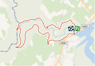
Tour Wandern von 5,2 km verfügbar auf Wallonien, Lüttich, Weismes. Diese Tour wird von Ramsesdeux65 vorgeschlagen.
Beschreibung
Le dépaysement est au bout des chemins des Cantons de l’Est. Celui surplombant la Warche est une invitation à la contemplation.
Marche venant de https://www.ostbelgien.eu/fr/fiche/hiking/balades-de-reve-08-robertville
Ort
Land:
Belgium
Region :
Wallonien
Abteilung/Provinz :
Lüttich
Kommune :
Weismes
Standort:
Waimes
Gehen Sie:(Dec)
Gehen Sie:(UTM)
294734 ; 5592884 (32U) N.
Kommentare
Touren in der Umgebung
![Tour Wandern Weismes - RB-Lg-32_Botrange_via-racc-2 - Photo](https://media.geolcdn.com/t/375/260/ext.jpg?maxdim=2&url=https%3A%2F%2Fservices.sitytrail.com%2FGeolivesWS%2FDownloadMedia.ashx%3FTrailID%3D402164%26Media%3D5ad16311-48f2-4779-8b73-f8bce456ef00.jpg)
![Wandern Wandern](https://static1.geolcdn.com/sitytour/trail-icons/101.png)
RB-Lg-32_Botrange_via-racc-2
Wandern
(6)
Weismes,
Wallonien,
Lüttich,
Belgium
![](/images/other/stat-length.png)
16,7 km | 22 km-effort
5h 4min
![](https://static1.geolcdn.com/siteimages/upload/files/16400158638029165_repeat_loop_refresh_sync_direction_icon.png)
Ja
![Tour Wandern Weismes - RB-Lg-32_Botrange_via-racc-1 - Photo](https://media.geolcdn.com/t/375/260/ext.jpg?maxdim=2&url=https%3A%2F%2Fservices.sitytrail.com%2FGeolivesWS%2FDownloadMedia.ashx%3FTrailID%3D402158%26Media%3D5ad16311-48f2-4779-8b73-f8bce456ef00.jpg)
![Wandern Wandern](https://static1.geolcdn.com/sitytour/trail-icons/101.png)
RB-Lg-32_Botrange_via-racc-1
Wandern
(7)
Weismes,
Wallonien,
Lüttich,
Belgium
![](/images/other/stat-length.png)
12,3 km | 15,7 km-effort
3h 34min
![](https://static1.geolcdn.com/siteimages/upload/files/16400158638029165_repeat_loop_refresh_sync_direction_icon.png)
Ja
![Tour Wandern Weismes - RB-Lg-32_Botrange - Photo](https://media.geolcdn.com/t/375/260/ext.jpg?maxdim=2&url=https%3A%2F%2Fservices.sitytrail.com%2FGeolivesWS%2FDownloadMedia.ashx%3FTrailID%3D402156%26Media%3Dfd59a9ea-7261-4ddd-8af9-0290eaea98e9.jpg)
![Wandern Wandern](https://static1.geolcdn.com/sitytour/trail-icons/101.png)
RB-Lg-32_Botrange
Wandern
(8)
Weismes,
Wallonien,
Lüttich,
Belgium
![](/images/other/stat-length.png)
19,6 km | 26 km-effort
5h 51min
![](https://static1.geolcdn.com/siteimages/upload/files/16400158638029165_repeat_loop_refresh_sync_direction_icon.png)
Ja
![Tour Wandern Malmedy - RB-Lg-31_Malmedy - Photo](https://media.geolcdn.com/t/375/260/ext.jpg?maxdim=2&url=https%3A%2F%2Fservices.sitytrail.com%2FGeolivesWS%2FDownloadMedia.ashx%3FTrailID%3D402114%26Media%3D216d2e53-3b66-4632-8b4d-0cea30889665.jpg)
![Wandern Wandern](https://static1.geolcdn.com/sitytour/trail-icons/101.png)
![Tour Wandern Weismes - Sourbrodt - Circuit Natura 2000, des sites qui valent le détour - Lg11 - Photo](https://media.geolcdn.com/t/375/260/ext.jpg?maxdim=2&url=https%3A%2F%2Fservices.sitytrail.com%2FGeolivesWS%2FDownloadMedia.ashx%3FTrailID%3D181919%26Media%3Dc17de19f-5f6c-4ae3-b0c2-a0399f656a6f.jpg)
![Wandern Wandern](https://static1.geolcdn.com/sitytour/trail-icons/101.png)
Sourbrodt - Circuit Natura 2000, des sites qui valent le détour - Lg11
Wandern
Einfach
(9)
Weismes,
Wallonien,
Lüttich,
Belgium
![](/images/other/stat-length.png)
7,3 km | 8,3 km-effort
1h 50min
![](https://static1.geolcdn.com/siteimages/upload/files/16400158638029165_repeat_loop_refresh_sync_direction_icon.png)
Ja
![Tour Wandern Weismes - Balade Peak Myrtille avec extension - restaurée - Photo](https://media.geolcdn.com/t/375/260/ext.jpg?maxdim=2&url=https%3A%2F%2Fstatic1.geolcdn.com%2Fsiteimages%2Fupload%2Ffiles%2F1553511878bg_sport_marche.png)
![Wandern Wandern](https://static1.geolcdn.com/sitytour/trail-icons/101.png)
Balade Peak Myrtille avec extension - restaurée
Wandern
Medium
(42)
Weismes,
Wallonien,
Lüttich,
Belgium
![](/images/other/stat-length.png)
4,9 km | 6 km-effort
1h 22min
![](https://static1.geolcdn.com/siteimages/upload/files/16400158638029165_repeat_loop_refresh_sync_direction_icon.png)
Ja
![Tour Wandern Weismes - Balade Peak Myrtille - restaurée - Photo](https://media.geolcdn.com/t/375/260/ext.jpg?maxdim=2&url=https%3A%2F%2Fstatic1.geolcdn.com%2Fsiteimages%2Fupload%2Ffiles%2F1553511878bg_sport_marche.png)
![Wandern Wandern](https://static1.geolcdn.com/sitytour/trail-icons/101.png)
Balade Peak Myrtille - restaurée
Wandern
Einfach
(20)
Weismes,
Wallonien,
Lüttich,
Belgium
![](/images/other/stat-length.png)
2,7 km | 3,3 km-effort
45min
![](https://static1.geolcdn.com/siteimages/upload/files/16400158638029165_repeat_loop_refresh_sync_direction_icon.png)
Ja
![Tour Wandern Weismes - 2023-11-10_22h16m17_t119964214_sur les versants de la warchenne w10.gpx.xml - Photo](https://media.geolcdn.com/t/375/260/ca458986-945b-4d88-aa31-13c1465e60e5.jpg&format=jpg&maxdim=2)
![Wandern Wandern](https://static1.geolcdn.com/sitytour/trail-icons/101.png)
2023-11-10_22h16m17_t119964214_sur les versants de la warchenne w10.gpx.xml
Wandern
Medium
(2)
Weismes,
Wallonien,
Lüttich,
Belgium
![](/images/other/stat-length.png)
6,8 km | 8,6 km-effort
1h 57min
![](https://static1.geolcdn.com/siteimages/upload/files/16400158638029165_repeat_loop_refresh_sync_direction_icon.png)
Ja
![Tour Wandern Weismes - Wanderung Peak Beer IPA (new) - Photo](https://media.geolcdn.com/t/375/260/69787633-7ca3-4264-9ec3-6547631cb468.png&format=jpg&maxdim=2)
![Wandern Wandern](https://static1.geolcdn.com/sitytour/trail-icons/101.png)
Wanderung Peak Beer IPA (new)
Wandern
Medium
(35)
Weismes,
Wallonien,
Lüttich,
Belgium
![](/images/other/stat-length.png)
9,7 km | 12 km-effort
2h 43min
![](https://static1.geolcdn.com/siteimages/upload/files/16400158638029165_repeat_loop_refresh_sync_direction_icon.png)
Ja