![](/images/other/stat-length.png)
![Tour Wandern Vinay - Vinay - La Blache - Les Ecuries de Charroi - Photo](https://media.geolcdn.com/t/1900/400/ext.pjpeg?maxdim=2&url=https%3A%2F%2Fstatic1.geolcdn.com%2Fsiteimages%2Fupload%2Ffiles%2F1553511878bg_sport_marche.png)
Vinay - La Blache - Les Ecuries de Charroi
crocau
Benutzer
![Länge](/images/other/stat-length.png)
![Maximale Höhe](https://static1.geolcdn.com/siteimages/upload/files/1508320355ic_sort_altitude_max_24dp.png)
![Positive Höhendifferenz](https://static1.geolcdn.com/siteimages/upload/files/1508320355ic_sort_den_pos_24dp.png)
![Km-Effort](/images/other/stat-length.png)
![Min. Höhe](https://static1.geolcdn.com/siteimages/upload/files/1508320355ic_sort_altitude_min_24dp.png)
![Negative Höhendifferenz](https://static1.geolcdn.com/siteimages/upload/files/1508320355ic_sort_den_neg_24dp.png)
![Boucle](https://static1.geolcdn.com/siteimages/upload/files/16400158638029165_repeat_loop_refresh_sync_direction_icon.png)
![Wandern](https://static1.geolcdn.com/sitytour/trail-icons/101.png)
2h00
Schwierigkeit : Sehr leicht
![Scannen Sie diesen QR-Code, um die Tour in der SityTrail-Anwendung zu öffnen](https://capi.geolives.com/qq0zvz2zws4bq2lad0pu/sitytour/trails/2371319/qr.png?size=200)
Kostenlosegpshiking-Anwendung
Über SityTrail
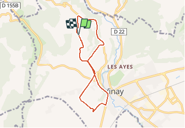
Tour Wandern von 6,8 km verfügbar auf Auvergne-Rhone-Alpen, Isère, Vinay. Diese Tour wird von crocau vorgeschlagen.
Beschreibung
ATTENTION: le point de départ et d'arrivée ne sont pas les bons sur la carte:
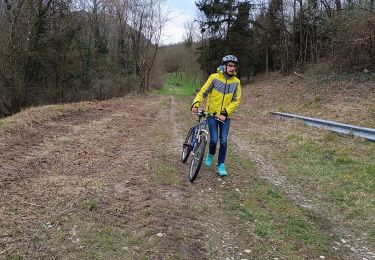
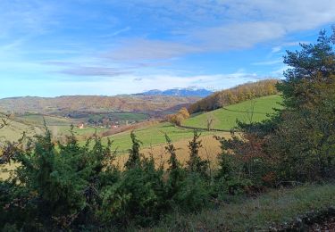
Un sentier jaune part de devant la piscine de Vinay( montée Penet). On arrive sur le plateau de la Blache et on traverse des fermes, la fauvette à tête noire nous accompagne.
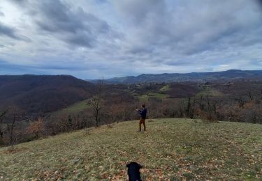
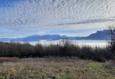
On coupe la route de Varacieux, on rejoint le chemin du Devers et on pointe sur Notre dame de Lozier. On aperçoit d'ailleurs en contre bas la route qui va à Serre Nerpol et le carrefour qui va à Notre Dame de Lozier.
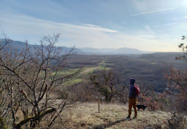
On grimpe jusqu'à L'écurie de Charroi et c'est là que l'on repointe sur Vinay. Petit à petit on regagne un sentier de rando jaune et rouge au dessus du chemin de Devers que l'on prend donc à l'envers pour finir notre 8.
Ort
Kommentare
Touren in der Umgebung
![Tour Wandern Vatilieu - 38 vatilieu - Photo](https://media.geolcdn.com/t/375/260/b269b01e-8989-441e-b082-d3b28704dde9.jpg&format=jpg&maxdim=2)
![Wandern Wandern](https://static1.geolcdn.com/sitytour/trail-icons/101.png)
Wandern
![](/images/other/stat-length.png)
![](https://static1.geolcdn.com/siteimages/upload/files/16400158638029165_repeat_loop_refresh_sync_direction_icon.png)
![Tour Rennrad Beaulieu - Beaulieu - Cognin par la pisciculture - Photo](https://media.geolcdn.com/t/375/260/35ef182e-2ae6-4c48-a6bb-babdec0fa24b.jpg&format=jpg&maxdim=2)
![Rennrad Rennrad](https://static1.geolcdn.com/sitytour/trail-icons/201.png)
Rennrad
![](/images/other/stat-length.png)
![](https://static1.geolcdn.com/siteimages/upload/files/16400158638029165_repeat_loop_refresh_sync_direction_icon.png)
![Tour Wandern Vatilieu - Les Crêtes de Vatilieu - Photo](https://media.geolcdn.com/t/375/260/2a3eeb1a-222b-49d5-98c3-83171aaed5b5.jpg&format=jpg&maxdim=2)
![Wandern Wandern](https://static1.geolcdn.com/sitytour/trail-icons/101.png)
Wandern
![](/images/other/stat-length.png)
![](https://static1.geolcdn.com/siteimages/upload/files/16400158638029165_repeat_loop_refresh_sync_direction_icon.png)
![Tour Mountainbike Vinay - Vinay-Serre de TrellinsPlaine-Pont de Treillins - Photo](https://media.geolcdn.com/t/375/260/ccbde911-1943-49b6-b0da-7e8d0a5dd2db.jpg&format=jpg&maxdim=2)
![Mountainbike Mountainbike](https://static1.geolcdn.com/sitytour/trail-icons/202.png)
Mountainbike
![](/images/other/stat-length.png)
![](https://static1.geolcdn.com/siteimages/upload/files/16400158638029165_repeat_loop_refresh_sync_direction_icon.png)
![Tour Wandern Serre-Nerpol - Crêtes de Senepol- La Routière - Photo](https://media.geolcdn.com/t/375/260/3ca501d9-5e9d-4131-9d18-b4898610f954.jpg&format=jpg&maxdim=2)
![Wandern Wandern](https://static1.geolcdn.com/sitytour/trail-icons/101.png)
Wandern
![](/images/other/stat-length.png)
![](https://static1.geolcdn.com/siteimages/upload/files/16400158638029165_repeat_loop_refresh_sync_direction_icon.png)
![Tour Wandern Chantesse - Traversée Chantesse Vitalieu Vinay - Photo](https://media.geolcdn.com/t/375/260/fcb44952-9760-427c-a2ff-8d11a64ffce4.jpg&format=jpg&maxdim=2)
![Wandern Wandern](https://static1.geolcdn.com/sitytour/trail-icons/101.png)
Wandern
![](/images/other/stat-length.png)
![](https://static1.geolcdn.com/siteimages/upload/files/16400158638029165_repeat_loop_refresh_sync_direction_icon.png)
![Tour Wandern Varacieux - Le Molard d'Essemat- Varacieux - Photo](https://media.geolcdn.com/t/375/260/a5d0403b-ce12-4804-bf0d-c01332f8e7cc.jpg&format=jpg&maxdim=2)
![Wandern Wandern](https://static1.geolcdn.com/sitytour/trail-icons/101.png)
Wandern
![](/images/other/stat-length.png)
![](https://static1.geolcdn.com/siteimages/upload/files/16400158638029165_repeat_loop_refresh_sync_direction_icon.png)
![Tour Mountainbike L'Albenc - autour de l'albenc - vtt - episode 1 - Photo](https://media.geolcdn.com/t/375/260/ext.jpg?maxdim=2&url=https%3A%2F%2Fservices.sitytrail.com%2FGeolivesWS%2FDownloadMedia.ashx%3FTrailID%3D1058080%26Media%3Dfix__20181017145623.jpg)
![Mountainbike Mountainbike](https://static1.geolcdn.com/sitytour/trail-icons/202.png)
Mountainbike
![](/images/other/stat-length.png)
![](https://static1.geolcdn.com/siteimages/upload/files/16400158638029165_repeat_loop_refresh_sync_direction_icon.png)
![Tour Wandern Chasselay - La table d'orientation à Chasselay marche - Photo](https://media.geolcdn.com/t/375/260/829b6e93-3b3c-41cf-8044-ed5d29756dfc.jpg&format=jpg&maxdim=2)
![Wandern Wandern](https://static1.geolcdn.com/sitytour/trail-icons/101.png)
Wandern
![](/images/other/stat-length.png)
![](https://static1.geolcdn.com/siteimages/upload/files/16400158638029165_repeat_loop_refresh_sync_direction_icon.png)