![](/images/other/stat-length.png)
![Tour Wandern Ascros - le mont Brune - Photo](https://media.geolcdn.com/t/1900/400/ext.pjpeg?maxdim=2&url=https%3A%2F%2Fservices.sitytrail.com%2FGeolivesWS%2FDownloadMedia.ashx%3FTrailID%3D235904%26Media%3Dfix__20131205104850.jpg)
le mont Brune
franquen
Benutzer
![Länge](/images/other/stat-length.png)
![Maximale Höhe](https://static1.geolcdn.com/siteimages/upload/files/1508320355ic_sort_altitude_max_24dp.png)
![Positive Höhendifferenz](https://static1.geolcdn.com/siteimages/upload/files/1508320355ic_sort_den_pos_24dp.png)
![Km-Effort](/images/other/stat-length.png)
![Min. Höhe](https://static1.geolcdn.com/siteimages/upload/files/1508320355ic_sort_altitude_min_24dp.png)
![Negative Höhendifferenz](https://static1.geolcdn.com/siteimages/upload/files/1508320355ic_sort_den_neg_24dp.png)
![Boucle](https://static1.geolcdn.com/siteimages/upload/files/16400158638029165_repeat_loop_refresh_sync_direction_icon.png)
![Wandern](https://static1.geolcdn.com/sitytour/trail-icons/101.png)
3h01
Schwierigkeit : Medium
![Scannen Sie diesen QR-Code, um die Tour in der SityTrail-Anwendung zu öffnen](https://capi.geolives.com/qq0zvz2zws4bq2lad0pu/sitytour/trails/235904/qr.png?size=200)
Kostenlosegpshiking-Anwendung
Über SityTrail
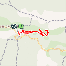
Tour Wandern von 7,8 km verfügbar auf Provence-Alpes-Côte d'Azur, Seealpen, Ascros. Diese Tour wird von franquen vorgeschlagen.
Beschreibung
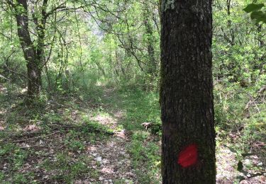
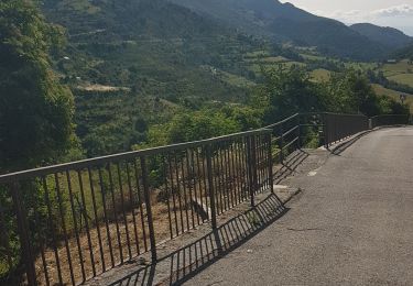
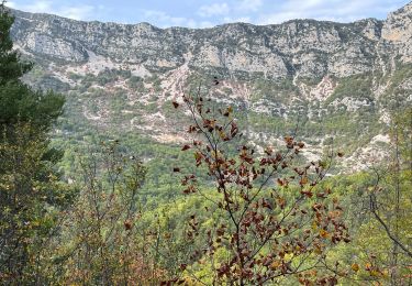
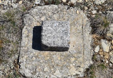
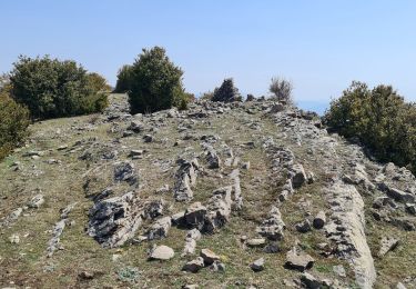
petite rando partant au point 305 entre Toudon et Ascros;arrêt à la chapelle Ste Baume (grotte). montée vers la baisse du Mont Brune (borne 95, 94, 93). au réservoir d'eau prendre à gauche pour la montée au Mont brune par la crête. rando sympa en arrière saison, superbe vue sur les montagnes enneigées.
Ort
Kommentare
Touren in der Umgebung
![Tour Zu Fuß Cuébris - Traversée de l'Estéron - Etape 4 - Photo](https://media.geolcdn.com/t/375/260/f8de4af9-418d-46b2-8971-b8252c239bb2.jpeg&format=jpg&maxdim=2)
![Zu Fuß Zu Fuß](https://static1.geolcdn.com/sitytour/trail-icons/100.png)
Zu Fuß
![](/images/other/stat-length.png)
![](https://static1.geolcdn.com/siteimages/upload/files/16400158638029165_repeat_loop_refresh_sync_direction_icon.png)
![Tour Zu Fuß Toudon - Cime des Collettes - Photo](https://media.geolcdn.com/t/375/260/fd183395-f287-4a75-ab4d-8f82bd86c556.jpeg&format=jpg&maxdim=2)
![Zu Fuß Zu Fuß](https://static1.geolcdn.com/sitytour/trail-icons/100.png)
Zu Fuß
![](/images/other/stat-length.png)
![](https://static1.geolcdn.com/siteimages/upload/files/16400158638029165_repeat_loop_refresh_sync_direction_icon.png)
![Tour Wandern Touët-sur-Var - Touet sur Var - Photo](https://media.geolcdn.com/t/375/260/591991c8-678f-43ce-bfb4-52a24dbc47c8.jpg&format=jpg&maxdim=2)
![Wandern Wandern](https://static1.geolcdn.com/sitytour/trail-icons/101.png)
Wandern
![](/images/other/stat-length.png)
![](https://static1.geolcdn.com/siteimages/upload/files/16400158638029165_repeat_loop_refresh_sync_direction_icon.png)
![Tour Wandern Ascros - ascros - Photo](https://media.geolcdn.com/t/375/260/687f6507-142d-4d39-bc85-9162ba4808fa.jpg&format=jpg&maxdim=2)
![Wandern Wandern](https://static1.geolcdn.com/sitytour/trail-icons/101.png)
Wandern
![](/images/other/stat-length.png)
![](https://static1.geolcdn.com/siteimages/upload/files/16400158638029165_repeat_loop_refresh_sync_direction_icon.png)
![Tour Wandern Roquestéron - Roquesteron : la cime de la Cacia - Photo](https://media.geolcdn.com/t/375/260/5b4bd870-0e3f-40d7-b02e-71dce0b18c61.jpg&format=jpg&maxdim=2)
![Wandern Wandern](https://static1.geolcdn.com/sitytour/trail-icons/101.png)
Wandern
![](/images/other/stat-length.png)
![](https://static1.geolcdn.com/siteimages/upload/files/16400158638029165_repeat_loop_refresh_sync_direction_icon.png)
![Tour Wandern Roquestéron - mont auviere de roquesteron - Photo](https://media.geolcdn.com/t/375/260/4e4b5cca-21a1-4d3e-af8b-c74d25458d28.jpg&format=jpg&maxdim=2)
![Wandern Wandern](https://static1.geolcdn.com/sitytour/trail-icons/101.png)
Wandern
![](/images/other/stat-length.png)
![](https://static1.geolcdn.com/siteimages/upload/files/16400158638029165_repeat_loop_refresh_sync_direction_icon.png)
![Tour Wandern Pierrefeu - mont brune - Photo](https://media.geolcdn.com/t/375/260/aaa7df74-5173-4c01-a387-0027aa66640a.jpg&format=jpg&maxdim=2)
![Wandern Wandern](https://static1.geolcdn.com/sitytour/trail-icons/101.png)
Wandern
![](/images/other/stat-length.png)
![](https://static1.geolcdn.com/siteimages/upload/files/16400158638029165_repeat_loop_refresh_sync_direction_icon.png)
![Tour Zu Fuß Touët-sur-Var - Traversée Touët-sur-Var – Villars-sur-Var - Photo](https://media.geolcdn.com/t/375/260/e3880c6a-e663-4d01-b142-f62d8840daf4.jpeg&format=jpg&maxdim=2)
![Zu Fuß Zu Fuß](https://static1.geolcdn.com/sitytour/trail-icons/100.png)
Zu Fuß
![](/images/other/stat-length.png)
![](https://static1.geolcdn.com/siteimages/upload/files/16400158638029165_repeat_loop_refresh_sync_direction_icon.png)
![Tour Zu Fuß Villars-sur-Var - Chapelle Saint-Jean - Photo](https://media.geolcdn.com/t/375/260/d00b81a8-2e28-44d5-b86a-fc3ec125a764.jpeg&format=jpg&maxdim=2)
![Zu Fuß Zu Fuß](https://static1.geolcdn.com/sitytour/trail-icons/100.png)
Zu Fuß
![](/images/other/stat-length.png)
![](https://static1.geolcdn.com/siteimages/upload/files/16400158638029165_repeat_loop_refresh_sync_direction_icon.png)