![](/images/other/stat-length.png)
![Tour Zu Fuß Pont-en-Royans - 24-FEV-19 - Photo](https://media.geolcdn.com/t/1900/400/ext.pjpeg?maxdim=2&url=https%3A%2F%2Fmedia.geolcdn.com%2Ff%2F26817dad-0ae5-406c-8e77-c4663e73c952.jpg)
24-FEV-19
TOULAUDIN
Benutzer
![Länge](/images/other/stat-length.png)
Länge
15,5 km
![Maximale Höhe](https://static1.geolcdn.com/siteimages/upload/files/1508320355ic_sort_altitude_max_24dp.png)
Maximale Höhe
1002 m
![Positive Höhendifferenz](https://static1.geolcdn.com/siteimages/upload/files/1508320355ic_sort_den_pos_24dp.png)
Positive Höhendifferenz
958 m
![Km-Effort](/images/other/stat-length.png)
Km-Effort
28 km
![Min. Höhe](https://static1.geolcdn.com/siteimages/upload/files/1508320355ic_sort_altitude_min_24dp.png)
Min. Höhe
198 m
![Negative Höhendifferenz](https://static1.geolcdn.com/siteimages/upload/files/1508320355ic_sort_den_neg_24dp.png)
Negative Höhendifferenz
964 m
![Boucle](https://static1.geolcdn.com/siteimages/upload/files/16400158638029165_repeat_loop_refresh_sync_direction_icon.png)
Boucle
Ja
Erstellungsdatum :
2020-03-07 09:03:12.791
Letzte Änderung :
2020-03-07 09:26:11.597
![Zu Fuß](https://static1.geolcdn.com/sitytour/trail-icons/100.png)
--
Schwierigkeit : Medium
![Scannen Sie diesen QR-Code, um die Tour in der SityTrail-Anwendung zu öffnen](https://capi.geolives.com/qq0zvz2zws4bq2lad0pu/sitytour/trails/2355936/qr.png?size=200)
Kostenlosegpshiking-Anwendung
Über SityTrail
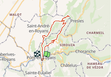
Tour Zu Fuß von 15,5 km verfügbar auf Auvergne-Rhone-Alpen, Isère, Pont-en-Royans. Diese Tour wird von TOULAUDIN vorgeschlagen.
Beschreibung
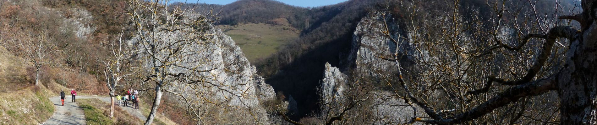
rando faite le 24/2/19 avec les Eisclops St Perollais au départ de Pont en Royans pas de difficultés mais assez long et partie route
Ort
Land:
France
Region :
Auvergne-Rhone-Alpen
Abteilung/Provinz :
Isère
Kommune :
Pont-en-Royans
Standort:
Unknown
Gehen Sie:(Dec)
Gehen Sie:(UTM)
684556 ; 4992213 (31T) N.
Kommentare
Touren in der Umgebung
![Tour Wandern Châtelus - Boucle Pas de l'Allier - Pas des Voutes - Photo](https://media.geolcdn.com/t/375/260/ext.jpg?maxdim=2&url=https%3A%2F%2Fservices.sitytrail.com%2FGeolivesWS%2FDownloadMedia.ashx%3FTrailID%3D105085%26Media%3D8675_1.jpg)
![Wandern Wandern](https://static1.geolcdn.com/sitytour/trail-icons/101.png)
Boucle Pas de l'Allier - Pas des Voutes
Wandern
Medium
(1)
Châtelus,
Auvergne-Rhone-Alpen,
Isère,
France
![](/images/other/stat-length.png)
10,1 km | 22 km-effort
4h 30min
![](https://static1.geolcdn.com/siteimages/upload/files/16400158638029165_repeat_loop_refresh_sync_direction_icon.png)
Ja
![Tour Wandern Choranche - La Grotte de Choranche - Photo](https://media.geolcdn.com/t/375/260/ext.jpg?maxdim=2&url=https%3A%2F%2Fstatic1.geolcdn.com%2Fsiteimages%2Fupload%2Ffiles%2F1553511878bg_sport_marche.png)
![Wandern Wandern](https://static1.geolcdn.com/sitytour/trail-icons/101.png)
La Grotte de Choranche
Wandern
Schwierig
(1)
Choranche,
Auvergne-Rhone-Alpen,
Isère,
France
![](/images/other/stat-length.png)
17,8 km | 33 km-effort
7h 6min
![](https://static1.geolcdn.com/siteimages/upload/files/16400158638029165_repeat_loop_refresh_sync_direction_icon.png)
Ja
![Tour Wandern Presles - Presles - rando amandière - (1) - Photo](https://media.geolcdn.com/t/375/260/ext.jpg?maxdim=2&url=https%3A%2F%2Fstatic1.geolcdn.com%2Fsiteimages%2Fupload%2Ffiles%2F1553511878bg_sport_marche.png)
![Wandern Wandern](https://static1.geolcdn.com/sitytour/trail-icons/101.png)
Presles - rando amandière - (1)
Wandern
Sehr leicht
(1)
Presles,
Auvergne-Rhone-Alpen,
Isère,
France
![](/images/other/stat-length.png)
5,6 km | 7,3 km-effort
1h 39min
![](https://static1.geolcdn.com/siteimages/upload/files/16400158638029165_repeat_loop_refresh_sync_direction_icon.png)
Ja
![Tour sport Saint-Laurent-en-Royans - St Laurent en Royans. La Laurentine - Photo](https://media.geolcdn.com/t/375/260/ext.jpg?maxdim=2&url=https%3A%2F%2Fmedia.geolcdn.com%2Ff%2F19b70eea-b54e-4263-823b-d99859d9e399.jpg)
St Laurent en Royans. La Laurentine
sport
Sehr leicht
Saint-Laurent-en-Royans,
Auvergne-Rhone-Alpen,
Drôme,
France
![](/images/other/stat-length.png)
16,3 km | 27 km-effort
Unbekannt
![](https://static1.geolcdn.com/siteimages/upload/files/16400158638029165_repeat_loop_refresh_sync_direction_icon.png)
Ja
![Tour Mountainbike Presles - Presles - Photo](https://media.geolcdn.com/t/375/260/ext.jpg?maxdim=2&url=https%3A%2F%2Fmedia.geolcdn.com%2Ff%2Fad184d0f-c9fc-4f0a-aae3-82c502b3651e.jpg)
![Mountainbike Mountainbike](https://static1.geolcdn.com/sitytour/trail-icons/202.png)
Presles
Mountainbike
Einfach
(1)
Presles,
Auvergne-Rhone-Alpen,
Isère,
France
![](/images/other/stat-length.png)
10,4 km | 14,9 km-effort
2h 26min
![](https://static1.geolcdn.com/siteimages/upload/files/16400158638029165_repeat_loop_refresh_sync_direction_icon.png)
Ja
![Tour Wandern Sainte-Eulalie-en-Royans - 26 ste eulalie - Photo](https://media.geolcdn.com/t/375/260/ext.jpg?maxdim=2&url=https%3A%2F%2Fmedia.geolcdn.com%2Ff%2Fcc17d7c1-039b-4811-aa20-433bfbe37107.jpg)
![Wandern Wandern](https://static1.geolcdn.com/sitytour/trail-icons/101.png)
26 ste eulalie
Wandern
Medium
Sainte-Eulalie-en-Royans,
Auvergne-Rhone-Alpen,
Drôme,
France
![](/images/other/stat-length.png)
14,8 km | 27 km-effort
6h 43min
![](https://static1.geolcdn.com/siteimages/upload/files/16400158638029165_repeat_loop_refresh_sync_direction_icon.png)
Nein
![Tour Wandern Châtelus - 38 pabro charmatte - Photo](https://media.geolcdn.com/t/375/260/ext.jpg?maxdim=2&url=https%3A%2F%2Fmedia.geolcdn.com%2Ff%2F983fca8d-ac95-4180-878f-eb8932bd4279.jpg)
![Wandern Wandern](https://static1.geolcdn.com/sitytour/trail-icons/101.png)
38 pabro charmatte
Wandern
Schwierig
Châtelus,
Auvergne-Rhone-Alpen,
Isère,
France
![](/images/other/stat-length.png)
11,4 km | 29 km-effort
7h 43min
![](https://static1.geolcdn.com/siteimages/upload/files/16400158638029165_repeat_loop_refresh_sync_direction_icon.png)
Ja
![Tour Nordic Walking Saint-Laurent-en-Royans - Circuit entre Saint-Laurent-en-Royans et Pont-en-Royans - Photo](https://media.geolcdn.com/t/375/260/ext.jpg?maxdim=2&url=https%3A%2F%2Fmedia.geolcdn.com%2Ff%2Fe35cab6e-ed35-4b24-b3a9-4e25ca3d2169.jpg)
![Nordic Walking Nordic Walking](https://static1.geolcdn.com/sitytour/trail-icons/102.png)
Circuit entre Saint-Laurent-en-Royans et Pont-en-Royans
Nordic Walking
Medium
Saint-Laurent-en-Royans,
Auvergne-Rhone-Alpen,
Drôme,
France
![](/images/other/stat-length.png)
13 km | 17,4 km-effort
5h 9min
![](https://static1.geolcdn.com/siteimages/upload/files/16400158638029165_repeat_loop_refresh_sync_direction_icon.png)
Ja
![Tour Wandern Pont-en-Royans - Grotte Balme Rousse - Photo](https://media.geolcdn.com/t/375/260/ext.jpg?maxdim=2&url=https%3A%2F%2Fmedia.geolcdn.com%2Ff%2F3f0931fe-fc35-4723-805e-db75d84253c6.jpg)
![Wandern Wandern](https://static1.geolcdn.com/sitytour/trail-icons/101.png)
Grotte Balme Rousse
Wandern
Schwierig
Pont-en-Royans,
Auvergne-Rhone-Alpen,
Isère,
France
![](/images/other/stat-length.png)
15,7 km | 32 km-effort
6h 43min
![](https://static1.geolcdn.com/siteimages/upload/files/16400158638029165_repeat_loop_refresh_sync_direction_icon.png)
Ja