![](/images/other/stat-length.png)
![Tour Andere Aktivitäten Châtel-Saint-Denis - Les Rosalys-Col de Villard - Photo](https://media.geolcdn.com/t/1900/400/ext.pjpeg?maxdim=2&url=https%3A%2F%2Fstatic1.geolcdn.com%2Fsiteimages%2Fupload%2Ffiles%2F1545311037marcheuse_200dpi.jpg)
Les Rosalys-Col de Villard
avrouge
Benutzer
![Länge](/images/other/stat-length.png)
Länge
8,7 km
![Maximale Höhe](https://static1.geolcdn.com/siteimages/upload/files/1508320355ic_sort_altitude_max_24dp.png)
Maximale Höhe
1451 m
![Positive Höhendifferenz](https://static1.geolcdn.com/siteimages/upload/files/1508320355ic_sort_den_pos_24dp.png)
Positive Höhendifferenz
450 m
![Km-Effort](/images/other/stat-length.png)
Km-Effort
14,7 km
![Min. Höhe](https://static1.geolcdn.com/siteimages/upload/files/1508320355ic_sort_altitude_min_24dp.png)
Min. Höhe
1133 m
![Negative Höhendifferenz](https://static1.geolcdn.com/siteimages/upload/files/1508320355ic_sort_den_neg_24dp.png)
Negative Höhendifferenz
450 m
![Boucle](https://static1.geolcdn.com/siteimages/upload/files/16400158638029165_repeat_loop_refresh_sync_direction_icon.png)
Boucle
Ja
Erstellungsdatum :
2014-12-11 00:00:00.0
Letzte Änderung :
2014-12-11 00:00:00.0
![Andere Aktivitäten](https://static1.geolcdn.com/sitytour/trail-icons/900.png)
--
Schwierigkeit : Unbekannt
![Scannen Sie diesen QR-Code, um die Tour in der SityTrail-Anwendung zu öffnen](https://capi.geolives.com/qq0zvz2zws4bq2lad0pu/sitytour/trails/23508/qr.png?size=200)
Kostenlosegpshiking-Anwendung
Über SityTrail
Tour Andere Aktivitäten von 8,7 km verfügbar auf Freiburg, Vivisbachbezirk, Châtel-Saint-Denis. Diese Tour wird von avrouge vorgeschlagen.
Beschreibung
Balade dans Ollon puis sentier de Provence et ses pins puis Forêt de Plantour. Retour par les vignes.
Ort
Land:
Switzerland
Region :
Freiburg
Abteilung/Provinz :
Vivisbachbezirk
Kommune :
Châtel-Saint-Denis
Standort:
Unknown
Gehen Sie:(Dec)
Gehen Sie:(UTM)
343917 ; 5153626 (32T) N.
Kommentare
Touren in der Umgebung
![Tour Schneeschuhwandern Châtel-Saint-Denis - Tour de la Cagne - Photo](https://media.geolcdn.com/t/375/260/ext.jpg?maxdim=2&url=https%3A%2F%2Fservices.sitytrail.com%2FGeolivesWS%2FDownloadMedia.ashx%3FTrailID%3D527248%26Media%3Dfix__20160218170630.jpg)
![Schneeschuhwandern Schneeschuhwandern](https://static1.geolcdn.com/sitytour/trail-icons/504.png)
Tour de la Cagne
Schneeschuhwandern
Medium
(1)
Châtel-Saint-Denis,
Freiburg,
Vivisbachbezirk,
Switzerland
![](/images/other/stat-length.png)
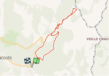
4,6 km | 7 km-effort
1h 44min
![](https://static1.geolcdn.com/siteimages/upload/files/16400158638029165_repeat_loop_refresh_sync_direction_icon.png)
Ja
![Tour Schneeschuhwandern Châtel-Saint-Denis - Raquette 8 Le Vuipay - Photo](https://media.geolcdn.com/t/375/260/ext.jpg?maxdim=2&url=https%3A%2F%2Fservices.sitytrail.com%2FGeolivesWS%2FDownloadMedia.ashx%3FTrailID%3D1119200%26Media%3Dfix__20190306135537.jpg)
![Schneeschuhwandern Schneeschuhwandern](https://static1.geolcdn.com/sitytour/trail-icons/504.png)
Raquette 8 Le Vuipay
Schneeschuhwandern
Medium
Châtel-Saint-Denis,
Freiburg,
Vivisbachbezirk,
Switzerland
![](/images/other/stat-length.png)
7,5 km | 13,1 km-effort
3h 46min
![](https://static1.geolcdn.com/siteimages/upload/files/16400158638029165_repeat_loop_refresh_sync_direction_icon.png)
Ja
![Tour Wandern Châtel-Saint-Denis - autour du Corbetta - Photo](https://media.geolcdn.com/t/375/260/ext.jpg?maxdim=2&url=https%3A%2F%2Fservices.sitytrail.com%2FGeolivesWS%2FDownloadMedia.ashx%3FTrailID%3D960115%26Media%3D20180507135802.jpg)
![Wandern Wandern](https://static1.geolcdn.com/sitytour/trail-icons/101.png)
autour du Corbetta
Wandern
Einfach
Châtel-Saint-Denis,
Freiburg,
Vivisbachbezirk,
Switzerland
![](/images/other/stat-length.png)
6,2 km | 9,3 km-effort
1h 44min
![](https://static1.geolcdn.com/siteimages/upload/files/16400158638029165_repeat_loop_refresh_sync_direction_icon.png)
Nein
![Tour Wandern Châtel-Saint-Denis - nose - Photo](https://media.geolcdn.com/t/375/260/ext.jpg?maxdim=2&url=https%3A%2F%2Fservices.sitytrail.com%2FGeolivesWS%2FDownloadMedia.ashx%3FTrailID%3D1123242%26Media%3Dfix__20190306135537.jpg)
![Wandern Wandern](https://static1.geolcdn.com/sitytour/trail-icons/101.png)
nose
Wandern
Sehr leicht
Châtel-Saint-Denis,
Freiburg,
Vivisbachbezirk,
Switzerland
![](/images/other/stat-length.png)
7,5 km | 13,1 km-effort
3h 46min
![](https://static1.geolcdn.com/siteimages/upload/files/16400158638029165_repeat_loop_refresh_sync_direction_icon.png)
Ja
![Tour Wandern Gruyères - 2018-07-26 Plan Francey Moleson en boucle - Photo](https://media.geolcdn.com/t/375/260/ext.jpg?maxdim=2&url=https%3A%2F%2Fservices.sitytrail.com%2FGeolivesWS%2FDownloadMedia.ashx%3FTrailID%3D1011161%26Media%3Dfix__20180726124837.jpg)
![Wandern Wandern](https://static1.geolcdn.com/sitytour/trail-icons/101.png)
2018-07-26 Plan Francey Moleson en boucle
Wandern
Medium
Gruyères,
Freiburg,
Greyerzbezirk,
Switzerland
![](/images/other/stat-length.png)
8 km | 16,1 km-effort
3h 12min
![](https://static1.geolcdn.com/siteimages/upload/files/16400158638029165_repeat_loop_refresh_sync_direction_icon.png)
Ja
![Tour Schneeschuhwandern Châtel-Saint-Denis - n10 - Photo](https://media.geolcdn.com/t/375/260/ext.jpg?maxdim=2&url=https%3A%2F%2Fservices.sitytrail.com%2FGeolivesWS%2FDownloadMedia.ashx%3FTrailID%3D526815%26Media%3Dfix__20160217163833.jpg)
![Schneeschuhwandern Schneeschuhwandern](https://static1.geolcdn.com/sitytour/trail-icons/504.png)
n10
Schneeschuhwandern
Einfach
Châtel-Saint-Denis,
Freiburg,
Vivisbachbezirk,
Switzerland
![](/images/other/stat-length.png)
3,3 km | 4,8 km-effort
1h 21min
![](https://static1.geolcdn.com/siteimages/upload/files/16400158638029165_repeat_loop_refresh_sync_direction_icon.png)
Ja
![Tour Mountainbike Blonay - Les Pléiades - Photo](https://media.geolcdn.com/t/375/260/ext.jpg?maxdim=2&url=https%3A%2F%2Fstatic1.geolcdn.com%2Fsiteimages%2Fupload%2Ffiles%2F1524743154velo.jpg)
![Mountainbike Mountainbike](https://static1.geolcdn.com/sitytour/trail-icons/202.png)
Les Pléiades
Mountainbike
Sehr leicht
Blonay,
Waadt,
District de la Riviera-Pays-d’Enhaut,
Switzerland
![](/images/other/stat-length.png)
35 km | 44 km-effort
11h 26min
![](https://static1.geolcdn.com/siteimages/upload/files/16400158638029165_repeat_loop_refresh_sync_direction_icon.png)
Nein
![Tour Wandern Châtel-Saint-Denis - Sentiers gourmande aux Paccots - Photo](https://media.geolcdn.com/t/375/260/ext.jpg?maxdim=2&url=https%3A%2F%2Fstatic1.geolcdn.com%2Fsiteimages%2Fupload%2Ffiles%2F1553511878bg_sport_marche.png)
![Wandern Wandern](https://static1.geolcdn.com/sitytour/trail-icons/101.png)
Sentiers gourmande aux Paccots
Wandern
Sehr leicht
Châtel-Saint-Denis,
Freiburg,
Vivisbachbezirk,
Switzerland
![](/images/other/stat-length.png)
11,4 km | 18,5 km-effort
Unbekannt
![](https://static1.geolcdn.com/siteimages/upload/files/16400158638029165_repeat_loop_refresh_sync_direction_icon.png)
Nein
![Tour Wandern Haut-Intyamon - st_test3 - Photo](https://media.geolcdn.com/t/375/260/ext.jpg?maxdim=2&url=https%3A%2F%2Fstatic1.geolcdn.com%2Fsiteimages%2Fupload%2Ffiles%2F1553511878bg_sport_marche.png)
![Wandern Wandern](https://static1.geolcdn.com/sitytour/trail-icons/101.png)
st_test3
Wandern
Sehr leicht
Haut-Intyamon,
Freiburg,
Greyerzbezirk,
Switzerland
![](/images/other/stat-length.png)
7,5 km | 11 km-effort
2h 34min
![](https://static1.geolcdn.com/siteimages/upload/files/16400158638029165_repeat_loop_refresh_sync_direction_icon.png)
Nein