![](/images/other/stat-length.png)
![Tour Wandern Walcourt - Yves-Gomezée _ Salle Communale _ Place Saint Laurent _ 5650 _ YVES-GOMEZEE - Photo](https://media.geolcdn.com/t/1900/400/6739740b-e838-4ca3-880b-5bf63ab2ad4f.jpg&format=pjpeg&maxdim=2)
Yves-Gomezée _ Salle Communale _ Place Saint Laurent _ 5650 _ YVES-GOMEZEE
jeangulu
Benutzer
![Länge](/images/other/stat-length.png)
Länge
23 km
![Maximale Höhe](https://static1.geolcdn.com/siteimages/upload/files/1508320355ic_sort_altitude_max_24dp.png)
Maximale Höhe
276 m
![Positive Höhendifferenz](https://static1.geolcdn.com/siteimages/upload/files/1508320355ic_sort_den_pos_24dp.png)
Positive Höhendifferenz
358 m
![Km-Effort](/images/other/stat-length.png)
Km-Effort
28 km
![Min. Höhe](https://static1.geolcdn.com/siteimages/upload/files/1508320355ic_sort_altitude_min_24dp.png)
Min. Höhe
195 m
![Negative Höhendifferenz](https://static1.geolcdn.com/siteimages/upload/files/1508320355ic_sort_den_neg_24dp.png)
Negative Höhendifferenz
347 m
![Boucle](https://static1.geolcdn.com/siteimages/upload/files/16400158638029165_repeat_loop_refresh_sync_direction_icon.png)
Boucle
Nein
Erstellungsdatum :
2020-03-01 09:03:50.283
Letzte Änderung :
2020-03-01 15:15:20.81
![Wandern](https://static1.geolcdn.com/sitytour/trail-icons/101.png)
5h51
Schwierigkeit : Medium
![Scannen Sie diesen QR-Code, um die Tour in der SityTrail-Anwendung zu öffnen](https://capi.geolives.com/qq0zvz2zws4bq2lad0pu/sitytour/trails/2350717/qr.png?size=200)
Kostenlosegpshiking-Anwendung
Über SityTrail
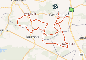
Tour Wandern von 23 km verfügbar auf Wallonien, Namur, Walcourt. Diese Tour wird von jeangulu vorgeschlagen.
Beschreibung
Les Godasses de Fraire _ NA O51 magnifique parcours beaucoup de forêts et des chemins de campagne longeant les prairies à refaire
Ort
Land:
Belgium
Region :
Wallonien
Abteilung/Provinz :
Namur
Kommune :
Walcourt
Standort:
Yves-Gomezée
Gehen Sie:(Dec)
Gehen Sie:(UTM)
607487 ; 5566253 (31U) N.
Kommentare
Touren in der Umgebung
![Wandern Wandern](https://static1.geolcdn.com/sitytour/trail-icons/101.png)
RB-Na-18_La-ruralité-condruzienne-dans-toute-sa-splendeur
Wandern
Sehr schwierig
(8)
Philippeville,
Wallonien,
Namur,
Belgium
![](/images/other/stat-length.png)
25 km | 30 km-effort
6h 49min
![](https://static1.geolcdn.com/siteimages/upload/files/16400158638029165_repeat_loop_refresh_sync_direction_icon.png)
Ja
![Tour Wandern Walcourt - Promenade à Chastrès - Photo](https://media.geolcdn.com/t/375/260/ext.jpg?maxdim=2&url=https%3A%2F%2Fservices.sitytrail.com%2FGeolivesWS%2FDownloadMedia.ashx%3FTrailID%3D117187%26Media%3D3da6a3b3-b81a-4fdc-a255-5d93ffb1cd0b.JPG)
![Wandern Wandern](https://static1.geolcdn.com/sitytour/trail-icons/101.png)
Promenade à Chastrès
Wandern
Sehr leicht
(1)
Walcourt,
Wallonien,
Namur,
Belgium
![](/images/other/stat-length.png)
4,7 km | 6 km-effort
1h 10min
![](https://static1.geolcdn.com/siteimages/upload/files/16400158638029165_repeat_loop_refresh_sync_direction_icon.png)
Ja
![Tour Wandern Walcourt - De Laneffe à Fraire par bois et campagnes - Photo](https://media.geolcdn.com/t/375/260/ext.jpg?maxdim=2&url=https%3A%2F%2Fservices.sitytrail.com%2FGeolivesWS%2FDownloadMedia.ashx%3FTrailID%3D95170%26Media%3Ddbcce443-4e55-417a-979c-b5ffbc4c1513.JPG)
![Wandern Wandern](https://static1.geolcdn.com/sitytour/trail-icons/101.png)
De Laneffe à Fraire par bois et campagnes
Wandern
Einfach
(1)
Walcourt,
Wallonien,
Namur,
Belgium
![](/images/other/stat-length.png)
12,9 km | 15,5 km-effort
3h 0min
![](https://static1.geolcdn.com/siteimages/upload/files/16400158638029165_repeat_loop_refresh_sync_direction_icon.png)
Ja
![Tour Wandern Florennes - De Saint-Aubin à Hemptinne par la vallée de l'Eau d'Yves - Photo](https://media.geolcdn.com/t/375/260/ext.jpg?maxdim=2&url=https%3A%2F%2Fstatic1.geolcdn.com%2Fsiteimages%2Fupload%2Ffiles%2F1553511878bg_sport_marche.png)
![Wandern Wandern](https://static1.geolcdn.com/sitytour/trail-icons/101.png)
De Saint-Aubin à Hemptinne par la vallée de l'Eau d'Yves
Wandern
Sehr leicht
(4)
Florennes,
Wallonien,
Namur,
Belgium
![](/images/other/stat-length.png)
8,1 km | 9,5 km-effort
Unbekannt
![](https://static1.geolcdn.com/siteimages/upload/files/16400158638029165_repeat_loop_refresh_sync_direction_icon.png)
Ja
![Tour Wandern Philippeville - Balade à Jamagne - Photo](https://media.geolcdn.com/t/375/260/ce171ec7-b1dd-4723-988d-0840c5fff04b.jpeg&format=jpg&maxdim=2)
![Wandern Wandern](https://static1.geolcdn.com/sitytour/trail-icons/101.png)
Balade à Jamagne
Wandern
Einfach
Philippeville,
Wallonien,
Namur,
Belgium
![](/images/other/stat-length.png)
5 km | 5,9 km-effort
1h 20min
![](https://static1.geolcdn.com/siteimages/upload/files/16400158638029165_repeat_loop_refresh_sync_direction_icon.png)
Ja
![Tour Wandern Walcourt - Balade à Yves-Gomezée - Walcourt - Photo](https://media.geolcdn.com/t/375/260/ce6fe3bc-56a4-4a73-8c7c-fe084ffe21fc.jpg&format=jpg&maxdim=2)
![Wandern Wandern](https://static1.geolcdn.com/sitytour/trail-icons/101.png)
Balade à Yves-Gomezée - Walcourt
Wandern
Schwierig
Walcourt,
Wallonien,
Namur,
Belgium
![](/images/other/stat-length.png)
10,8 km | 13,2 km-effort
2h 59min
![](https://static1.geolcdn.com/siteimages/upload/files/16400158638029165_repeat_loop_refresh_sync_direction_icon.png)
Ja
![Tour Wandern Florennes - Balade à Morialmé - Photo](https://media.geolcdn.com/t/375/260/ee08c3f8-21b9-47bc-8d3f-083f28314d9e.jpg&format=jpg&maxdim=2)
![Wandern Wandern](https://static1.geolcdn.com/sitytour/trail-icons/101.png)
Balade à Morialmé
Wandern
Schwierig
Florennes,
Wallonien,
Namur,
Belgium
![](/images/other/stat-length.png)
10,4 km | 12,1 km-effort
3h 37min
![](https://static1.geolcdn.com/siteimages/upload/files/16400158638029165_repeat_loop_refresh_sync_direction_icon.png)
Ja
![Tour Wandern Philippeville - Balade à Jamiolle - Photo](https://media.geolcdn.com/t/375/260/06c8177c-21a1-421c-9fc3-909bbee83463.jpeg&format=jpg&maxdim=2)
![Wandern Wandern](https://static1.geolcdn.com/sitytour/trail-icons/101.png)
Balade à Jamiolle
Wandern
Medium
Philippeville,
Wallonien,
Namur,
Belgium
![](/images/other/stat-length.png)
6 km | 6,9 km-effort
1h 46min
![](https://static1.geolcdn.com/siteimages/upload/files/16400158638029165_repeat_loop_refresh_sync_direction_icon.png)
Ja
![Mountainbike Mountainbike](https://static1.geolcdn.com/sitytour/trail-icons/202.png)
Florennes_20220213_082911
Mountainbike
Sehr schwierig
Florennes,
Wallonien,
Namur,
Belgium
![](/images/other/stat-length.png)
43 km | 51 km-effort
3h 33min
![](https://static1.geolcdn.com/siteimages/upload/files/16400158638029165_repeat_loop_refresh_sync_direction_icon.png)
Ja