![](/images/other/stat-length.png)
![Tour Wandern Toudon - cime des Colettes - Photo](https://media.geolcdn.com/t/1900/400/ext.pjpeg?maxdim=2&url=https%3A%2F%2Fservices.sitytrail.com%2FGeolivesWS%2FDownloadMedia.ashx%3FTrailID%3D234784%26Media%3Dfix__20131128111541.jpg)
cime des Colettes
franquen
Benutzer
![Länge](/images/other/stat-length.png)
Länge
7,7 km
![Maximale Höhe](https://static1.geolcdn.com/siteimages/upload/files/1508320355ic_sort_altitude_max_24dp.png)
Maximale Höhe
1498 m
![Positive Höhendifferenz](https://static1.geolcdn.com/siteimages/upload/files/1508320355ic_sort_den_pos_24dp.png)
Positive Höhendifferenz
538 m
![Km-Effort](/images/other/stat-length.png)
Km-Effort
14,6 km
![Min. Höhe](https://static1.geolcdn.com/siteimages/upload/files/1508320355ic_sort_altitude_min_24dp.png)
Min. Höhe
984 m
![Negative Höhendifferenz](https://static1.geolcdn.com/siteimages/upload/files/1508320355ic_sort_den_neg_24dp.png)
Negative Höhendifferenz
463 m
![Boucle](https://static1.geolcdn.com/siteimages/upload/files/16400158638029165_repeat_loop_refresh_sync_direction_icon.png)
Boucle
Nein
Erstellungsdatum :
2014-12-10 00:00:00.0
Letzte Änderung :
2014-12-10 00:00:00.0
![Wandern](https://static1.geolcdn.com/sitytour/trail-icons/101.png)
3h40
Schwierigkeit : Medium
![Scannen Sie diesen QR-Code, um die Tour in der SityTrail-Anwendung zu öffnen](https://capi.geolives.com/qq0zvz2zws4bq2lad0pu/sitytour/trails/234784/qr.png?size=200)
Kostenlosegpshiking-Anwendung
Über SityTrail
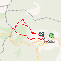
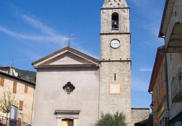
Tour Wandern von 7,7 km verfügbar auf Provence-Alpes-Côte d'Azur, Seealpen, Toudon. Diese Tour wird von franquen vorgeschlagen.
Beschreibung
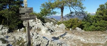
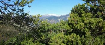
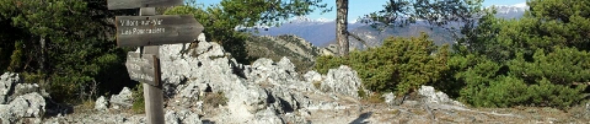
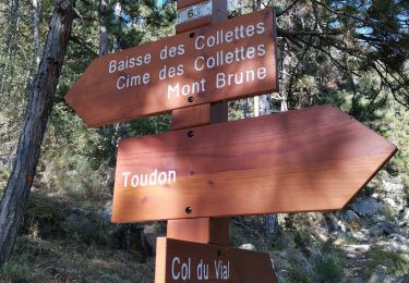
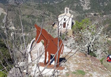
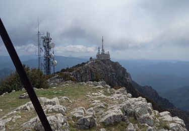
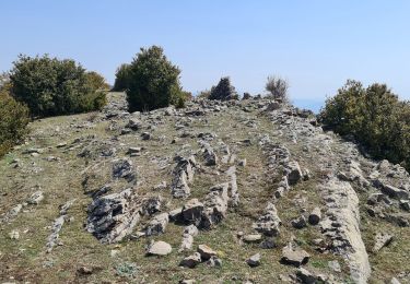
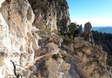
départ du lavoir de Toudon pour une boucle de 3h30 environ, le plus souvent côté sud avec un panorama splendide sur les cimes enneigées du Cheiron puis du Mercantour. notamment à la cime des Colettes avec un 360° magnifique.
Ort
Land:
France
Region :
Provence-Alpes-Côte d'Azur
Abteilung/Provinz :
Seealpen
Kommune :
Toudon
Standort:
Unknown
Gehen Sie:(Dec)
Gehen Sie:(UTM)
348456 ; 4862683 (32T) N.
Kommentare
Touren in der Umgebung
![Tour Zu Fuß Toudon - Cime des Collettes - Photo](https://media.geolcdn.com/t/375/260/fd183395-f287-4a75-ab4d-8f82bd86c556.jpeg&format=jpg&maxdim=2)
![Zu Fuß Zu Fuß](https://static1.geolcdn.com/sitytour/trail-icons/100.png)
Cime des Collettes
Zu Fuß
Einfach
Toudon,
Provence-Alpes-Côte d'Azur,
Seealpen,
France
![](/images/other/stat-length.png)
7 km | 13,4 km-effort
3h 3min
![](https://static1.geolcdn.com/siteimages/upload/files/16400158638029165_repeat_loop_refresh_sync_direction_icon.png)
Ja
![Tour Wandern Revest-les-Roches - Balme de Vial - Photo](https://media.geolcdn.com/t/375/260/73ac1471-1060-4737-8ded-c7a6c570aa13.jpg&format=jpg&maxdim=2)
![Wandern Wandern](https://static1.geolcdn.com/sitytour/trail-icons/101.png)
Balme de Vial
Wandern
Medium
Revest-les-Roches,
Provence-Alpes-Côte d'Azur,
Seealpen,
France
![](/images/other/stat-length.png)
7,4 km | 14,6 km-effort
5h 1min
![](https://static1.geolcdn.com/siteimages/upload/files/16400158638029165_repeat_loop_refresh_sync_direction_icon.png)
Nein
![Tour Wandern La Tour - Pic charvet, son Fort, Chapelle St Antoine, Tournefort - Photo](https://media.geolcdn.com/t/375/260/f393b76f-0e11-49af-9bd1-d986a17cd1fb.jpg&format=jpg&maxdim=2)
![Wandern Wandern](https://static1.geolcdn.com/sitytour/trail-icons/101.png)
Pic charvet, son Fort, Chapelle St Antoine, Tournefort
Wandern
Einfach
La Tour,
Provence-Alpes-Côte d'Azur,
Seealpen,
France
![](/images/other/stat-length.png)
12,8 km | 23 km-effort
5h 10min
![](https://static1.geolcdn.com/siteimages/upload/files/16400158638029165_repeat_loop_refresh_sync_direction_icon.png)
Ja
![Tour Wandern Revest-les-Roches - Mont Vial 1550m 18-04-22 - Photo](https://media.geolcdn.com/t/375/260/d6f644e7-05d3-4637-b742-d9794d83f920.jpg&format=jpg&maxdim=2)
![Wandern Wandern](https://static1.geolcdn.com/sitytour/trail-icons/101.png)
Mont Vial 1550m 18-04-22
Wandern
Medium
Revest-les-Roches,
Provence-Alpes-Côte d'Azur,
Seealpen,
France
![](/images/other/stat-length.png)
9,7 km | 19,1 km-effort
3h 30min
![](https://static1.geolcdn.com/siteimages/upload/files/16400158638029165_repeat_loop_refresh_sync_direction_icon.png)
Ja
![Tour Wandern Pierrefeu - mont brune - Photo](https://media.geolcdn.com/t/375/260/aaa7df74-5173-4c01-a387-0027aa66640a.jpg&format=jpg&maxdim=2)
![Wandern Wandern](https://static1.geolcdn.com/sitytour/trail-icons/101.png)
mont brune
Wandern
Schwierig
Pierrefeu,
Provence-Alpes-Côte d'Azur,
Seealpen,
France
![](/images/other/stat-length.png)
8 km | 13,7 km-effort
3h 13min
![](https://static1.geolcdn.com/siteimages/upload/files/16400158638029165_repeat_loop_refresh_sync_direction_icon.png)
Ja
![Tour Zu Fuß Villars-sur-Var - Chapelle Saint-Jean - Photo](https://media.geolcdn.com/t/375/260/d00b81a8-2e28-44d5-b86a-fc3ec125a764.jpeg&format=jpg&maxdim=2)
![Zu Fuß Zu Fuß](https://static1.geolcdn.com/sitytour/trail-icons/100.png)
Chapelle Saint-Jean
Zu Fuß
Einfach
Villars-sur-Var,
Provence-Alpes-Côte d'Azur,
Seealpen,
France
![](/images/other/stat-length.png)
5 km | 9,7 km-effort
2h 12min
![](https://static1.geolcdn.com/siteimages/upload/files/16400158638029165_repeat_loop_refresh_sync_direction_icon.png)
Ja
![Tour Wandern Toudon - Baisse des Colettes et Mt Brune de Toudon - Photo](https://media.geolcdn.com/t/375/260/20f8a02d-71d1-45f3-9a82-b8f740ad91d7.jpg&format=jpg&maxdim=2)
![Wandern Wandern](https://static1.geolcdn.com/sitytour/trail-icons/101.png)
Baisse des Colettes et Mt Brune de Toudon
Wandern
Medium
(1)
Toudon,
Provence-Alpes-Côte d'Azur,
Seealpen,
France
![](/images/other/stat-length.png)
13,3 km | 24 km-effort
4h 39min
![](https://static1.geolcdn.com/siteimages/upload/files/16400158638029165_repeat_loop_refresh_sync_direction_icon.png)
Ja
![Wandern Wandern](https://static1.geolcdn.com/sitytour/trail-icons/101.png)
Malaussene : Le Canal de l'Adous
Wandern
Medium
Malaussène,
Provence-Alpes-Côte d'Azur,
Seealpen,
France
![](/images/other/stat-length.png)
8,8 km | 11,8 km-effort
3h 59min
![](https://static1.geolcdn.com/siteimages/upload/files/16400158638029165_repeat_loop_refresh_sync_direction_icon.png)
Ja
![Tour Wandern Toudon - FFR - la Cime des Colettes - Photo](https://media.geolcdn.com/t/375/260/c8ab2dfa-0b9f-4ca3-be95-f436f8f0fdc4.jpg&format=jpg&maxdim=2)
![Wandern Wandern](https://static1.geolcdn.com/sitytour/trail-icons/101.png)
FFR - la Cime des Colettes
Wandern
Medium
(1)
Toudon,
Provence-Alpes-Côte d'Azur,
Seealpen,
France
![](/images/other/stat-length.png)
7,8 km | 14,9 km-effort
4h 50min
![](https://static1.geolcdn.com/siteimages/upload/files/16400158638029165_repeat_loop_refresh_sync_direction_icon.png)
Ja
BonjourBelle balade de 1/2 saison, assez alternative ( forêt champs maquis etc). 1 partie en ubac (côté vallée du Var) donc neige persistante au printemps.