![](/images/other/stat-length.png)
![Tour Wandern Avignon - AVIGNON Île de la Barthelasse - Photo](https://media.geolcdn.com/t/1900/400/ext.pjpeg?maxdim=2&url=https%3A%2F%2Fstatic1.geolcdn.com%2Fsiteimages%2Fupload%2Ffiles%2F1553511878bg_sport_marche.png)
AVIGNON Île de la Barthelasse
Manoune
Benutzer
![Länge](/images/other/stat-length.png)
![Maximale Höhe](https://static1.geolcdn.com/siteimages/upload/files/1508320355ic_sort_altitude_max_24dp.png)
![Positive Höhendifferenz](https://static1.geolcdn.com/siteimages/upload/files/1508320355ic_sort_den_pos_24dp.png)
![Km-Effort](/images/other/stat-length.png)
![Min. Höhe](https://static1.geolcdn.com/siteimages/upload/files/1508320355ic_sort_altitude_min_24dp.png)
![Negative Höhendifferenz](https://static1.geolcdn.com/siteimages/upload/files/1508320355ic_sort_den_neg_24dp.png)
![Boucle](https://static1.geolcdn.com/siteimages/upload/files/16400158638029165_repeat_loop_refresh_sync_direction_icon.png)
![Wandern](https://static1.geolcdn.com/sitytour/trail-icons/101.png)
4h26
Schwierigkeit : Einfach
![Scannen Sie diesen QR-Code, um die Tour in der SityTrail-Anwendung zu öffnen](https://capi.geolives.com/qq0zvz2zws4bq2lad0pu/sitytour/trails/2346908/qr.png?size=200)
Kostenlosegpshiking-Anwendung
Über SityTrail
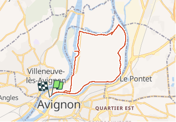
Tour Wandern von 16,3 km verfügbar auf Provence-Alpes-Côte d'Azur, Vaucluse, Avignon. Diese Tour wird von Manoune vorgeschlagen.
Beschreibung
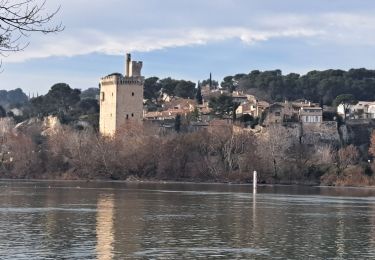
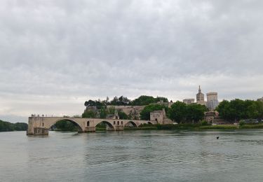
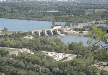
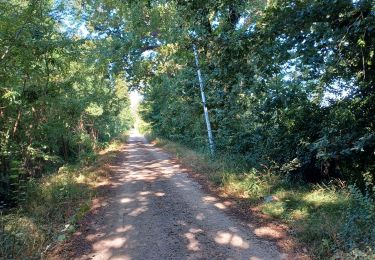
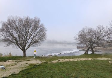
Départ parking Bagatelle, suivre le le bord du Rhône, Halte Fluviale, la Projette, Château de la Barthelasse, la Grande Bastide, Laurent, les Cabanes, ( attention depuis notre passage du 29:12:19, nous avons trouvé des barrières sur le passage du chemin, nous les avons contourné , des panneaux nous indiquent propriété privée) voir s'il est possible de contourner les Cabanes) ensuite la Merveille, face à la cascade de l'Ouvèze. Suivre le bras mort du Rhône jusqu'au Parc des Libertés, traversée de la D 228 et suivre le canal jusqu'à l'écluse d'Avignon et retour au parking.
Ort
Kommentare
Touren in der Umgebung
![Tour Wandern Avignon - ile de la Barthelasse - Photo](https://media.geolcdn.com/t/375/260/e0f4fcd0-18e6-4d74-a6c3-369037188a72.jpg&format=jpg&maxdim=2)
![Wandern Wandern](https://static1.geolcdn.com/sitytour/trail-icons/101.png)
Wandern
![](/images/other/stat-length.png)
![](https://static1.geolcdn.com/siteimages/upload/files/16400158638029165_repeat_loop_refresh_sync_direction_icon.png)
![Tour Wandern Avignon - ile de Barthelasse 1ere du top 10 des balades d Avignon... pauvres avignonais... - Photo](https://media.geolcdn.com/t/375/260/963c3ee6-7875-4ee3-ace7-cd7418306cf7.jpg&format=jpg&maxdim=2)
![Wandern Wandern](https://static1.geolcdn.com/sitytour/trail-icons/101.png)
Wandern
![](/images/other/stat-length.png)
![](https://static1.geolcdn.com/siteimages/upload/files/16400158638029165_repeat_loop_refresh_sync_direction_icon.png)
![Wandern Wandern](https://static1.geolcdn.com/sitytour/trail-icons/101.png)
Wandern
![](/images/other/stat-length.png)
![](https://static1.geolcdn.com/siteimages/upload/files/16400158638029165_repeat_loop_refresh_sync_direction_icon.png)
![Tour Wandern Avignon - 2024-08-24 Barthelasse - grand bosquet - Photo](https://media.geolcdn.com/t/375/260/ad341062-73ba-4d71-afc7-9fafb7f4736e.jpg&format=jpg&maxdim=2)
![Wandern Wandern](https://static1.geolcdn.com/sitytour/trail-icons/101.png)
Wandern
![](/images/other/stat-length.png)
![](https://static1.geolcdn.com/siteimages/upload/files/16400158638029165_repeat_loop_refresh_sync_direction_icon.png)
![Tour Laufen Le Pontet - Le Pontet - Photo](https://media.geolcdn.com/t/375/260/12075d35-a7fc-4605-a13a-ec9078e8b636.jpg&format=jpg&maxdim=2)
![Laufen Laufen](https://static1.geolcdn.com/sitytour/trail-icons/103.png)
Laufen
![](/images/other/stat-length.png)
![](https://static1.geolcdn.com/siteimages/upload/files/16400158638029165_repeat_loop_refresh_sync_direction_icon.png)
![Tour Wandern Avignon - baguenaudage en Avignon - Photo](https://media.geolcdn.com/t/375/260/307f00c2-1f87-43b1-84c1-7a62203d52aa.jpg&format=jpg&maxdim=2)
![Wandern Wandern](https://static1.geolcdn.com/sitytour/trail-icons/101.png)
Wandern
![](/images/other/stat-length.png)
![](https://static1.geolcdn.com/siteimages/upload/files/16400158638029165_repeat_loop_refresh_sync_direction_icon.png)
![Tour Zu Fuß Avignon - Canal du Puy - 1 - Photo](https://media.geolcdn.com/t/375/260/f4209b10-1fc5-4574-92df-51fcf3ed9802.jpeg&format=jpg&maxdim=2)
![Zu Fuß Zu Fuß](https://static1.geolcdn.com/sitytour/trail-icons/100.png)
Zu Fuß
![](/images/other/stat-length.png)
![](https://static1.geolcdn.com/siteimages/upload/files/16400158638029165_repeat_loop_refresh_sync_direction_icon.png)
![Tour Laufen Avignon - running hopital - Photo](https://media.geolcdn.com/t/375/260/ext.jpg?maxdim=2&url=https%3A%2F%2Fstatic1.geolcdn.com%2Fsiteimages%2Fupload%2Ffiles%2F1524743154running.jpg)
![Laufen Laufen](https://static1.geolcdn.com/sitytour/trail-icons/103.png)
Laufen
![](/images/other/stat-length.png)
![](https://static1.geolcdn.com/siteimages/upload/files/16400158638029165_repeat_loop_refresh_sync_direction_icon.png)
![Tour Radtourismus Les Angles - Avant dernière étape - Photo](https://media.geolcdn.com/t/375/260/77ee41c0-83af-4a4a-a427-853d84ab2441.jpg&format=jpg&maxdim=2)
![Radtourismus Radtourismus](https://static1.geolcdn.com/sitytour/trail-icons/204.png)
Radtourismus
![](/images/other/stat-length.png)
![](https://static1.geolcdn.com/siteimages/upload/files/16400158638029165_repeat_loop_refresh_sync_direction_icon.png)