![](/images/other/stat-length.png)
![Tour Wandern Accous - Chapelle Saint Christau à Accous - Photo](https://media.geolcdn.com/t/1900/400/ext.pjpeg?maxdim=2&url=https%3A%2F%2Fmedia.geolcdn.com%2Ff%2F5ab7b7b3-c348-4ef7-9617-66955570a368.jpg)
Chapelle Saint Christau à Accous
bedous
Benutzer
![Länge](/images/other/stat-length.png)
Länge
3,6 km
![Maximale Höhe](https://static1.geolcdn.com/siteimages/upload/files/1508320355ic_sort_altitude_max_24dp.png)
Maximale Höhe
836 m
![Positive Höhendifferenz](https://static1.geolcdn.com/siteimages/upload/files/1508320355ic_sort_den_pos_24dp.png)
Positive Höhendifferenz
146 m
![Km-Effort](/images/other/stat-length.png)
Km-Effort
5,6 km
![Min. Höhe](https://static1.geolcdn.com/siteimages/upload/files/1508320355ic_sort_altitude_min_24dp.png)
Min. Höhe
697 m
![Negative Höhendifferenz](https://static1.geolcdn.com/siteimages/upload/files/1508320355ic_sort_den_neg_24dp.png)
Negative Höhendifferenz
147 m
![Boucle](https://static1.geolcdn.com/siteimages/upload/files/16400158638029165_repeat_loop_refresh_sync_direction_icon.png)
Boucle
Ja
Erstellungsdatum :
2020-02-23 13:36:51.274
Letzte Änderung :
2020-02-23 18:14:29.253
![Wandern](https://static1.geolcdn.com/sitytour/trail-icons/101.png)
1h29
Schwierigkeit : Einfach
![Scannen Sie diesen QR-Code, um die Tour in der SityTrail-Anwendung zu öffnen](https://capi.geolives.com/qq0zvz2zws4bq2lad0pu/sitytour/trails/2344383/qr.png?size=200)
Kostenlosegpshiking-Anwendung
Über SityTrail
Tour Wandern von 3,6 km verfügbar auf Neu-Aquitanien, Pyrenäen-Atlantik, Accous. Diese Tour wird von bedous vorgeschlagen.
Beschreibung
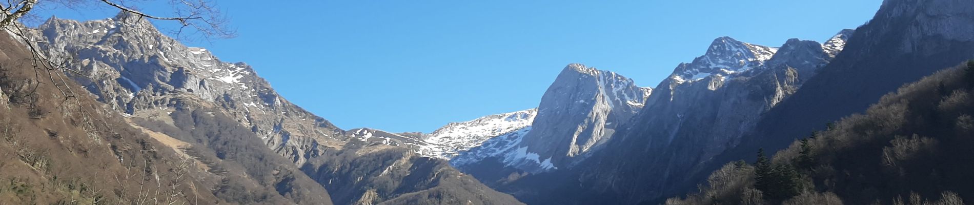
Boucle au départ de la chapelle, descente jusqu'au gave La Berthe que l'on suit au travers d'un pâturage pour rejoindre un chemin boisé et remonter par la route bitumée. Magnifique vue sur le cirque d'Accous.
Ort
Land:
France
Region :
Neu-Aquitanien
Abteilung/Provinz :
Pyrenäen-Atlantik
Kommune :
Accous
Standort:
Unknown
Gehen Sie:(Dec)
Gehen Sie:(UTM)
698199 ; 4760670 (30T) N.
Kommentare
Touren in der Umgebung
![Tour Wandern Bedous - Le Tour de Saudious - Photo](https://media.geolcdn.com/t/375/260/ext.jpg?maxdim=2&url=https%3A%2F%2Fservices.sitytrail.com%2FGeolivesWS%2FDownloadMedia.ashx%3FTrailID%3D110248%26Media%3D5551_6.jpg)
![Wandern Wandern](https://static1.geolcdn.com/sitytour/trail-icons/101.png)
Le Tour de Saudious
Wandern
Medium
(1)
Bedous,
Neu-Aquitanien,
Pyrenäen-Atlantik,
France
![](/images/other/stat-length.png)
6 km | 8,7 km-effort
1h 30min
![](https://static1.geolcdn.com/siteimages/upload/files/16400158638029165_repeat_loop_refresh_sync_direction_icon.png)
Ja
![Tour Zu Fuß Bedous - BEDOUS les chemins du gaves G4](https://media.geolcdn.com/t/375/260/ext.jpg?maxdim=2&url=https%3A%2F%2Fmedia.geolcdn.com%2Ff%2F9e91315c-b4be-4963-9ba8-48016c7d9f89.jpg)
![Zu Fuß Zu Fuß](https://static1.geolcdn.com/sitytour/trail-icons/100.png)
BEDOUS les chemins du gaves G4 "4014081"
Zu Fuß
Einfach
Bedous,
Neu-Aquitanien,
Pyrenäen-Atlantik,
France
![](/images/other/stat-length.png)
11,2 km | 12,9 km-effort
2h 55min
![](https://static1.geolcdn.com/siteimages/upload/files/16400158638029165_repeat_loop_refresh_sync_direction_icon.png)
Ja
![Tour Zu Fuß Bedous - BEDOUS Le tour du Bugala par Osse en Aspe - Photo](https://media.geolcdn.com/t/375/260/ext.jpg?maxdim=2&url=https%3A%2F%2Fmedia.geolcdn.com%2Ff%2F6e8c2570-bd56-4eb0-9c8b-883f3443f589.JPG)
![Zu Fuß Zu Fuß](https://static1.geolcdn.com/sitytour/trail-icons/100.png)
BEDOUS Le tour du Bugala par Osse en Aspe
Zu Fuß
Einfach
Bedous,
Neu-Aquitanien,
Pyrenäen-Atlantik,
France
![](/images/other/stat-length.png)
11,6 km | 16,8 km-effort
3h 56min
![](https://static1.geolcdn.com/siteimages/upload/files/16400158638029165_repeat_loop_refresh_sync_direction_icon.png)
Ja
![Tour Zu Fuß Accous - Sommet du Poey asp122 - Photo](https://media.geolcdn.com/t/375/260/ext.jpg?maxdim=2&url=https%3A%2F%2Fmedia.geolcdn.com%2Ff%2F2d07cf2c-8954-4ab2-916e-821bbcb77891.jpeg)
![Zu Fuß Zu Fuß](https://static1.geolcdn.com/sitytour/trail-icons/100.png)
Sommet du Poey asp122
Zu Fuß
Einfach
Accous,
Neu-Aquitanien,
Pyrenäen-Atlantik,
France
![](/images/other/stat-length.png)
3,5 km | 5,7 km-effort
1h 17min
![](https://static1.geolcdn.com/siteimages/upload/files/16400158638029165_repeat_loop_refresh_sync_direction_icon.png)
Ja
![Tour Zu Fuß Cette-Eygun - Granges de Cette asp56 - Photo](https://media.geolcdn.com/t/375/260/ext.jpg?maxdim=2&url=https%3A%2F%2Fmedia.geolcdn.com%2Ff%2F45ec37bb-ebfa-4fac-a648-b2e50bb11731.jpeg)
![Zu Fuß Zu Fuß](https://static1.geolcdn.com/sitytour/trail-icons/100.png)
Granges de Cette asp56
Zu Fuß
Einfach
Cette-Eygun,
Neu-Aquitanien,
Pyrenäen-Atlantik,
France
![](/images/other/stat-length.png)
5,4 km | 10,2 km-effort
2h 18min
![](https://static1.geolcdn.com/siteimages/upload/files/16400158638029165_repeat_loop_refresh_sync_direction_icon.png)
Ja
![Tour Zu Fuß Cette-Eygun - Cabane de Lhèze asp116 - Photo](https://media.geolcdn.com/t/375/260/ext.jpg?maxdim=2&url=https%3A%2F%2Fmedia.geolcdn.com%2Ff%2F45ec37bb-ebfa-4fac-a648-b2e50bb11731.jpeg)
![Zu Fuß Zu Fuß](https://static1.geolcdn.com/sitytour/trail-icons/100.png)
Cabane de Lhèze asp116
Zu Fuß
Einfach
Cette-Eygun,
Neu-Aquitanien,
Pyrenäen-Atlantik,
France
![](/images/other/stat-length.png)
3,6 km | 9,7 km-effort
2h 11min
![](https://static1.geolcdn.com/siteimages/upload/files/16400158638029165_repeat_loop_refresh_sync_direction_icon.png)
Nein
![Tour Zu Fuß Cette-Eygun - Cabanes de Narbèze asp117 - Photo](https://media.geolcdn.com/t/375/260/ext.jpg?maxdim=2&url=https%3A%2F%2Fmedia.geolcdn.com%2Ff%2F45ec37bb-ebfa-4fac-a648-b2e50bb11731.jpeg)
![Zu Fuß Zu Fuß](https://static1.geolcdn.com/sitytour/trail-icons/100.png)
Cabanes de Narbèze asp117
Zu Fuß
Einfach
Cette-Eygun,
Neu-Aquitanien,
Pyrenäen-Atlantik,
France
![](/images/other/stat-length.png)
6,5 km | 16,6 km-effort
3h 45min
![](https://static1.geolcdn.com/siteimages/upload/files/16400158638029165_repeat_loop_refresh_sync_direction_icon.png)
Nein
![Tour Zu Fuß Cette-Eygun - Tour de Lasies asp115 - Photo](https://media.geolcdn.com/t/375/260/ext.jpg?maxdim=2&url=https%3A%2F%2Fmedia.geolcdn.com%2Ff%2Fc7bf7b32-3f7c-4bff-b706-8b021e3df474.jpeg)
![Zu Fuß Zu Fuß](https://static1.geolcdn.com/sitytour/trail-icons/100.png)
Tour de Lasies asp115
Zu Fuß
Einfach
Cette-Eygun,
Neu-Aquitanien,
Pyrenäen-Atlantik,
France
![](/images/other/stat-length.png)
4,3 km | 8,7 km-effort
1h 59min
![](https://static1.geolcdn.com/siteimages/upload/files/16400158638029165_repeat_loop_refresh_sync_direction_icon.png)
Nein
![Tour Zu Fuß Osse-en-Aspe - Tour panoramique Osse-Athas asp109 - Photo](https://media.geolcdn.com/t/375/260/ext.jpg?maxdim=2&url=https%3A%2F%2Fmedia.geolcdn.com%2Ff%2Ffd742eea-9420-4aa3-9b7d-11c6f4a57c86.jpeg)
![Zu Fuß Zu Fuß](https://static1.geolcdn.com/sitytour/trail-icons/100.png)
Tour panoramique Osse-Athas asp109
Zu Fuß
Einfach
Osse-en-Aspe,
Neu-Aquitanien,
Pyrenäen-Atlantik,
France
![](/images/other/stat-length.png)
8,3 km | 12,1 km-effort
2h 44min
![](https://static1.geolcdn.com/siteimages/upload/files/16400158638029165_repeat_loop_refresh_sync_direction_icon.png)
Nein