![](/images/other/stat-length.png)
![Tour Wandern Villepreux - Villepreux - Rennemoulin par le ru de Gally - Photo](https://media.geolcdn.com/t/1900/400/0e03ca7a-616b-4646-96f7-c96f8b055868.jpg&format=pjpeg&maxdim=2)
Villepreux - Rennemoulin par le ru de Gally
BPinglier
Benutzer
![Länge](/images/other/stat-length.png)
Länge
7,9 km
![Maximale Höhe](https://static1.geolcdn.com/siteimages/upload/files/1508320355ic_sort_altitude_max_24dp.png)
Maximale Höhe
116 m
![Positive Höhendifferenz](https://static1.geolcdn.com/siteimages/upload/files/1508320355ic_sort_den_pos_24dp.png)
Positive Höhendifferenz
75 m
![Km-Effort](/images/other/stat-length.png)
Km-Effort
8,9 km
![Min. Höhe](https://static1.geolcdn.com/siteimages/upload/files/1508320355ic_sort_altitude_min_24dp.png)
Min. Höhe
83 m
![Negative Höhendifferenz](https://static1.geolcdn.com/siteimages/upload/files/1508320355ic_sort_den_neg_24dp.png)
Negative Höhendifferenz
75 m
![Boucle](https://static1.geolcdn.com/siteimages/upload/files/16400158638029165_repeat_loop_refresh_sync_direction_icon.png)
Boucle
Ja
Erstellungsdatum :
2020-02-22 09:45:14.09
Letzte Änderung :
2020-02-23 08:52:16.637
![Wandern](https://static1.geolcdn.com/sitytour/trail-icons/101.png)
1h40
Schwierigkeit : Sehr leicht
![Scannen Sie diesen QR-Code, um die Tour in der SityTrail-Anwendung zu öffnen](https://capi.geolives.com/qq0zvz2zws4bq2lad0pu/sitytour/trails/2343205/qr.png?size=200)
Kostenlosegpshiking-Anwendung
Über SityTrail
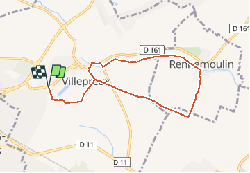
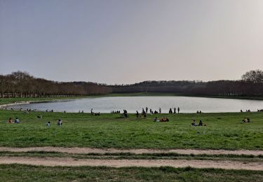
Tour Wandern von 7,9 km verfügbar auf Île-de-France, Yvelines, Villepreux. Diese Tour wird von BPinglier vorgeschlagen.
Beschreibung
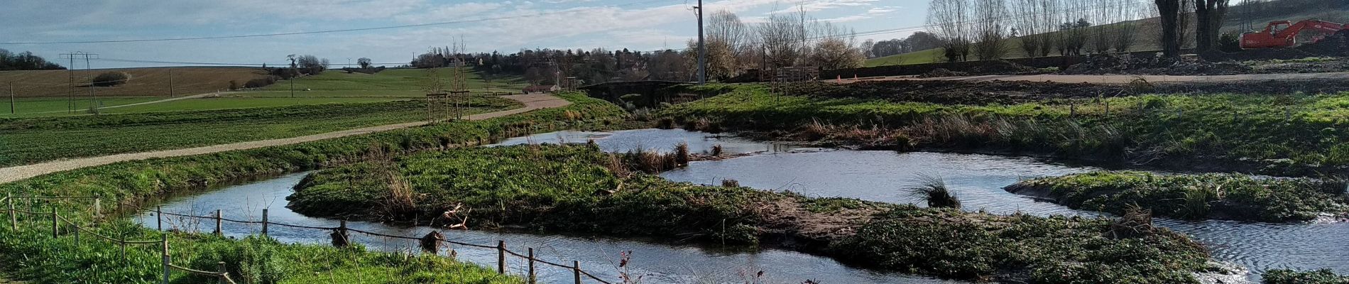
Départ de la Mairie de Villepreux, on rejoint Rennemoulin par un chemin créé récemment le long du ru de Gally
Retour par l'Allée Royale.
Prévoir des chaussures adaptées pour franchir un passage très boueux.
Ort
Land:
France
Region :
Île-de-France
Abteilung/Provinz :
Yvelines
Kommune :
Villepreux
Standort:
Unknown
Gehen Sie:(Dec)
Gehen Sie:(UTM)
427009 ; 5409100 (31U) N.
Kommentare
Touren in der Umgebung
![Tour Wandern L'Étang-la-Ville - GRP CV-IDF 2023 - Photo](https://media.geolcdn.com/t/375/260/5b76ffb0-032e-4c30-9eff-c534da0117fa.jpg&format=jpg&maxdim=2)
![Wandern Wandern](https://static1.geolcdn.com/sitytour/trail-icons/101.png)
GRP CV-IDF 2023
Wandern
Schwierig
(1)
L'Étang-la-Ville,
Île-de-France,
Yvelines,
France
![](/images/other/stat-length.png)
10,7 km | 13,7 km-effort
3h 6min
![](https://static1.geolcdn.com/siteimages/upload/files/16400158638029165_repeat_loop_refresh_sync_direction_icon.png)
Nein
![Tour Wandern Plaisir - Plaisir et forêt de Ste Apolline - Photo](https://media.geolcdn.com/t/375/260/ext.jpg?maxdim=2&url=https%3A%2F%2Fservices.sitytrail.com%2FGeolivesWS%2FDownloadMedia.ashx%3FTrailID%3D317587%26Media%3D16850_6.jpg)
![Wandern Wandern](https://static1.geolcdn.com/sitytour/trail-icons/101.png)
Plaisir et forêt de Ste Apolline
Wandern
Medium
(2)
Plaisir,
Île-de-France,
Yvelines,
France
![](/images/other/stat-length.png)
12,7 km | 15,4 km-effort
2h 30min
![](https://static1.geolcdn.com/siteimages/upload/files/16400158638029165_repeat_loop_refresh_sync_direction_icon.png)
Ja
![Tour Wandern L'Étang-la-Ville - Gare de St Nom - Boucle nocturne Gr ~2h 8,5km - Photo](https://media.geolcdn.com/t/375/260/ext.jpg?maxdim=2&url=https%3A%2F%2Fstatic1.geolcdn.com%2Fsiteimages%2Fupload%2Ffiles%2F1553511878bg_sport_marche.png)
![Wandern Wandern](https://static1.geolcdn.com/sitytour/trail-icons/101.png)
Gare de St Nom - Boucle nocturne Gr ~2h 8,5km
Wandern
Einfach
(1)
L'Étang-la-Ville,
Île-de-France,
Yvelines,
France
![](/images/other/stat-length.png)
24 km | 28 km-effort
12h 14min
![](https://static1.geolcdn.com/siteimages/upload/files/16400158638029165_repeat_loop_refresh_sync_direction_icon.png)
Nein
![Tour Zu Fuß L'Étang-la-Ville - Le tour du Grand Paris par le GR1 Etape 2 - Saint Nom la Bretèche - Triel sur Seine - Photo](https://media.geolcdn.com/t/375/260/1683ad58-8376-4601-9416-cabd4c0df082.jpg&format=jpg&maxdim=2)
![Zu Fuß Zu Fuß](https://static1.geolcdn.com/sitytour/trail-icons/100.png)
Le tour du Grand Paris par le GR1 Etape 2 - Saint Nom la Bretèche - Triel sur...
Zu Fuß
Schwierig
L'Étang-la-Ville,
Île-de-France,
Yvelines,
France
![](/images/other/stat-length.png)
31 km | 36 km-effort
8h 16min
![](https://static1.geolcdn.com/siteimages/upload/files/16400158638029165_repeat_loop_refresh_sync_direction_icon.png)
Nein
![Tour Mountainbike Saint-Cyr-l'École - 14102013 - Photo](https://media.geolcdn.com/t/375/260/ext.jpg?maxdim=2&url=https%3A%2F%2Fstatic1.geolcdn.com%2Fsiteimages%2Fupload%2Ffiles%2F1524743154velo.jpg)
![Mountainbike Mountainbike](https://static1.geolcdn.com/sitytour/trail-icons/202.png)
14102013
Mountainbike
Medium
(1)
Saint-Cyr-l'École,
Île-de-France,
Yvelines,
France
![](/images/other/stat-length.png)
42 km | 50 km-effort
3h 11min
![](https://static1.geolcdn.com/siteimages/upload/files/16400158638029165_repeat_loop_refresh_sync_direction_icon.png)
Ja
![Wandern Wandern](https://static1.geolcdn.com/sitytour/trail-icons/101.png)
2024-11-12-Rennemoulin-fontaine de Maltoute
Wandern
Medium
Rennemoulin,
Île-de-France,
Yvelines,
France
![](/images/other/stat-length.png)
6,6 km | 7,8 km-effort
1h 47min
![](https://static1.geolcdn.com/siteimages/upload/files/16400158638029165_repeat_loop_refresh_sync_direction_icon.png)
Ja
![Tour Zu Fuß Chavenay - PR - Photo](https://media.geolcdn.com/t/375/260/f8e6bd7a-5875-409f-a50f-40b8535a7dfc.jpeg&format=jpg&maxdim=2)
![Zu Fuß Zu Fuß](https://static1.geolcdn.com/sitytour/trail-icons/100.png)
![Tour Hybrid-Bike Fontenay-le-Fleury - Fontenay Versailles - Photo](https://media.geolcdn.com/t/375/260/819f1d88-4c93-4136-a66a-fc78c90ee4dd.jpg&format=jpg&maxdim=2)
![Hybrid-Bike Hybrid-Bike](https://static1.geolcdn.com/sitytour/trail-icons/203.png)
Fontenay Versailles
Hybrid-Bike
Einfach
(1)
Fontenay-le-Fleury,
Île-de-France,
Yvelines,
France
![](/images/other/stat-length.png)
20 km | 24 km-effort
1h 37min
![](https://static1.geolcdn.com/siteimages/upload/files/16400158638029165_repeat_loop_refresh_sync_direction_icon.png)
Ja
![Tour Wandern L'Étang-la-Ville - Forêt de Marly - Photo](https://media.geolcdn.com/t/375/260/2acaf939-1c04-4175-a4e2-9c6944adf1a1.jpg&format=jpg&maxdim=2)
![Wandern Wandern](https://static1.geolcdn.com/sitytour/trail-icons/101.png)
Forêt de Marly
Wandern
Einfach
L'Étang-la-Ville,
Île-de-France,
Yvelines,
France
![](/images/other/stat-length.png)
6,8 km | 8,5 km-effort
2h 1min
![](https://static1.geolcdn.com/siteimages/upload/files/16400158638029165_repeat_loop_refresh_sync_direction_icon.png)
Ja