![](/images/other/stat-length.png)
![Tour Wandern Cornus - du pas de licou a saint rome de berliéres - Photo](https://media.geolcdn.com/t/1900/400/ext.pjpeg?maxdim=2&url=https%3A%2F%2Fstatic1.geolcdn.com%2Fsiteimages%2Fupload%2Ffiles%2F1553511878bg_sport_marche.png)
du pas de licou a saint rome de berliéres
pipette12
Benutzer
![Länge](/images/other/stat-length.png)
Länge
12 km
![Maximale Höhe](https://static1.geolcdn.com/siteimages/upload/files/1508320355ic_sort_altitude_max_24dp.png)
Maximale Höhe
835 m
![Positive Höhendifferenz](https://static1.geolcdn.com/siteimages/upload/files/1508320355ic_sort_den_pos_24dp.png)
Positive Höhendifferenz
384 m
![Km-Effort](/images/other/stat-length.png)
Km-Effort
17,1 km
![Min. Höhe](https://static1.geolcdn.com/siteimages/upload/files/1508320355ic_sort_altitude_min_24dp.png)
Min. Höhe
555 m
![Negative Höhendifferenz](https://static1.geolcdn.com/siteimages/upload/files/1508320355ic_sort_den_neg_24dp.png)
Negative Höhendifferenz
383 m
![Boucle](https://static1.geolcdn.com/siteimages/upload/files/16400158638029165_repeat_loop_refresh_sync_direction_icon.png)
Boucle
Ja
Erstellungsdatum :
2014-12-10 00:00:00.0
Letzte Änderung :
2014-12-10 00:00:00.0
![Wandern](https://static1.geolcdn.com/sitytour/trail-icons/101.png)
--
Schwierigkeit : Medium
![Scannen Sie diesen QR-Code, um die Tour in der SityTrail-Anwendung zu öffnen](https://capi.geolives.com/qq0zvz2zws4bq2lad0pu/sitytour/trails/234319/qr.png?size=200)
Kostenlosegpshiking-Anwendung
Über SityTrail
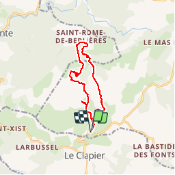
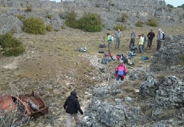
Tour Wandern von 12 km verfügbar auf Okzitanien, Aveyron, Cornus. Diese Tour wird von pipette12 vorgeschlagen.
Beschreibung
randonnée agréable à faire mais pour descendre sur saint rome il vous fzaudra chercher le départ dans les buits qui bordent le plateau
Ort
Land:
France
Region :
Okzitanien
Abteilung/Provinz :
Aveyron
Kommune :
Cornus
Standort:
Unknown
Gehen Sie:(Dec)
Gehen Sie:(UTM)
514111 ; 4854098 (31T) N.
Kommentare
Touren in der Umgebung
![Tour Rennrad Fondamente - Roqueredonde, Luna, Avène - Photo](https://media.geolcdn.com/t/375/260/0bc8f2a5-41ab-4868-92fc-03bdddb1c0d8.jpg&format=jpg&maxdim=2)
![Rennrad Rennrad](https://static1.geolcdn.com/sitytour/trail-icons/201.png)
Roqueredonde, Luna, Avène
Rennrad
Medium
Fondamente,
Okzitanien,
Aveyron,
France
![](/images/other/stat-length.png)
56 km | 71 km-effort
3h 4min
![](https://static1.geolcdn.com/siteimages/upload/files/16400158638029165_repeat_loop_refresh_sync_direction_icon.png)
Ja
![Tour Wandern Cornus - Sorgues - Photo](https://media.geolcdn.com/t/375/260/ext.jpg?maxdim=2&url=https%3A%2F%2Fstatic1.geolcdn.com%2Fsiteimages%2Fupload%2Ffiles%2F1553511878bg_sport_marche.png)
![Wandern Wandern](https://static1.geolcdn.com/sitytour/trail-icons/101.png)
Sorgues
Wandern
Schwierig
(1)
Cornus,
Okzitanien,
Aveyron,
France
![](/images/other/stat-length.png)
13,4 km | 19 km-effort
3h 59min
![](https://static1.geolcdn.com/siteimages/upload/files/16400158638029165_repeat_loop_refresh_sync_direction_icon.png)
Ja
![Tour Wandern Cornus - guilhaumard n 1 col de licous au col de licous - Photo](https://media.geolcdn.com/t/375/260/ext.jpg?maxdim=2&url=https%3A%2F%2Fstatic1.geolcdn.com%2Fsiteimages%2Fupload%2Ffiles%2F1553511878bg_sport_marche.png)
![Wandern Wandern](https://static1.geolcdn.com/sitytour/trail-icons/101.png)
guilhaumard n 1 col de licous au col de licous
Wandern
Einfach
(2)
Cornus,
Okzitanien,
Aveyron,
France
![](/images/other/stat-length.png)
14 km | 16,6 km-effort
3h 44min
![](https://static1.geolcdn.com/siteimages/upload/files/16400158638029165_repeat_loop_refresh_sync_direction_icon.png)
Ja
![Tour Wandern Roqueredonde - --Roqueredonde-- OR-4937792:D'Autignaguet au mas de Greze - Photo](https://media.geolcdn.com/t/375/260/ext.jpg?maxdim=2&url=https%3A%2F%2Fstatic1.geolcdn.com%2Fsiteimages%2Fupload%2Ffiles%2F1553511878bg_sport_marche.png)
![Wandern Wandern](https://static1.geolcdn.com/sitytour/trail-icons/101.png)
--Roqueredonde-- OR-4937792:D'Autignaguet au mas de Greze
Wandern
Sehr schwierig
(1)
Roqueredonde,
Okzitanien,
Hérault,
France
![](/images/other/stat-length.png)
13,9 km | 19,5 km-effort
4h 26min
![](https://static1.geolcdn.com/siteimages/upload/files/16400158638029165_repeat_loop_refresh_sync_direction_icon.png)
Ja
![Tour Wandern Roqueredonde - escandorgue - Photo](https://media.geolcdn.com/t/375/260/6c0c24a0-5d65-46a9-ab83-c4abb4a24843.jpg&format=jpg&maxdim=2)
![Wandern Wandern](https://static1.geolcdn.com/sitytour/trail-icons/101.png)
escandorgue
Wandern
Medium
Roqueredonde,
Okzitanien,
Hérault,
France
![](/images/other/stat-length.png)
15,6 km | 22 km-effort
5h 8min
![](https://static1.geolcdn.com/siteimages/upload/files/16400158638029165_repeat_loop_refresh_sync_direction_icon.png)
Ja
![Tour Wandern Cornus - mas raynal - Photo](https://media.geolcdn.com/t/375/260/ext.jpg?maxdim=2&url=https%3A%2F%2Fservices.sitytrail.com%2FGeolivesWS%2FDownloadMedia.ashx%3FTrailID%3D1082580%26Media%3Dfix__20140320141005.jpg)
![Wandern Wandern](https://static1.geolcdn.com/sitytour/trail-icons/101.png)
![Tour Wandern Cornus - mas raynal - Photo](https://media.geolcdn.com/t/375/260/ext.jpg?maxdim=2&url=https%3A%2F%2Fservices.sitytrail.com%2FGeolivesWS%2FDownloadMedia.ashx%3FTrailID%3D258902%26Media%3Dfix__20140320101319.jpg)
![Wandern Wandern](https://static1.geolcdn.com/sitytour/trail-icons/101.png)
![Tour Wandern Roqueredonde - Roqueredonde l'Escandorgue - Photo](https://media.geolcdn.com/t/375/260/ext.jpg?maxdim=2&url=https%3A%2F%2Fstatic1.geolcdn.com%2Fsiteimages%2Fupload%2Ffiles%2F1553511878bg_sport_marche.png)
![Wandern Wandern](https://static1.geolcdn.com/sitytour/trail-icons/101.png)
Roqueredonde l'Escandorgue
Wandern
Medium
(2)
Roqueredonde,
Okzitanien,
Hérault,
France
![](/images/other/stat-length.png)
17,2 km | 25 km-effort
5h 12min
![](https://static1.geolcdn.com/siteimages/upload/files/16400158638029165_repeat_loop_refresh_sync_direction_icon.png)
Ja
![Tour Mountainbike Roqueredonde - Grande Traversée de l'Hérault à VTT - de Roqueredonde à Montbarri - Photo](https://media.geolcdn.com/t/375/260/ext.jpg?maxdim=2&url=https%3A%2F%2Fservices.sitytrail.com%2FGeolivesWS%2FDownloadMedia.ashx%3FTrailID%3D107559%26Media%3D12518_3.jpg)
![Mountainbike Mountainbike](https://static1.geolcdn.com/sitytour/trail-icons/202.png)
Grande Traversée de l'Hérault à VTT - de Roqueredonde à Montbarri
Mountainbike
Schwierig
Roqueredonde,
Okzitanien,
Hérault,
France
![](/images/other/stat-length.png)
38 km | 51 km-effort
5h 0min
![](https://static1.geolcdn.com/siteimages/upload/files/16400158638029165_repeat_loop_refresh_sync_direction_icon.png)
Nein