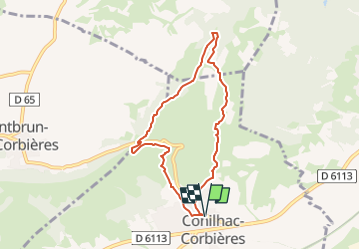
![](/images/other/stat-length.png)
![Tour Wandern Conilhac-Corbières - CONILHAC Les Eoliennes - Photo](https://media.geolcdn.com/t/1900/400/61a6f362-e725-47d8-be5f-e8d8f9b00380.jpg&format=pjpeg&maxdim=2)
CONILHAC Les Eoliennes
Licianus2
Benutzer
![Länge](/images/other/stat-length.png)
![Maximale Höhe](https://static1.geolcdn.com/siteimages/upload/files/1508320355ic_sort_altitude_max_24dp.png)
![Positive Höhendifferenz](https://static1.geolcdn.com/siteimages/upload/files/1508320355ic_sort_den_pos_24dp.png)
![Km-Effort](/images/other/stat-length.png)
![Min. Höhe](https://static1.geolcdn.com/siteimages/upload/files/1508320355ic_sort_altitude_min_24dp.png)
![Negative Höhendifferenz](https://static1.geolcdn.com/siteimages/upload/files/1508320355ic_sort_den_neg_24dp.png)
![Boucle](https://static1.geolcdn.com/siteimages/upload/files/16400158638029165_repeat_loop_refresh_sync_direction_icon.png)
![Wandern](https://static1.geolcdn.com/sitytour/trail-icons/101.png)
1h27
Schwierigkeit : Sehr leicht
![Scannen Sie diesen QR-Code, um die Tour in der SityTrail-Anwendung zu öffnen](https://capi.geolives.com/qq0zvz2zws4bq2lad0pu/sitytour/trails/2340645/qr.png?size=200)
Kostenlosegpshiking-Anwendung
Über SityTrail
Tour Wandern von 7,4 km verfügbar auf Okzitanien, Aude, Conilhac-Corbières. Diese Tour wird von Licianus2 vorgeschlagen.
Beschreibung
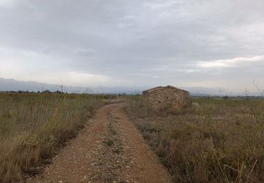
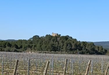
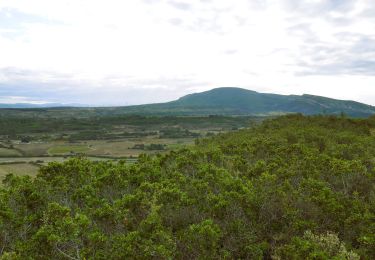
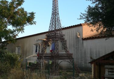
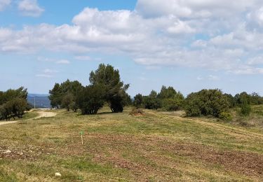
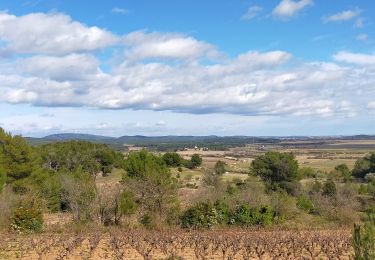
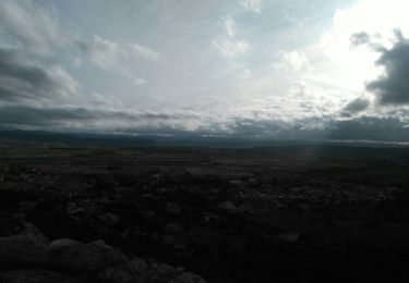
Petite boucle au dessus de Conilhac-Corbières autour des éoliennes de Lézignan et de Conilhac-Corbières. Quelques pistes et quelques sentiers, facile mais pas très ombragé ni très abrité du cers (vent du nord). Comme sur beaucoup de circuits dans le secteur, pas mal de cailloux justifiant de bonnes chaussures. Par contre, de magnifiques vues sur la plaine de Lézignan et de Montbrun. Panoramiques sur les Corbières, l’Alaric, la Montagne Noire et même les Pyrénées enneigées par beau temps.
Ort
Kommentare
Touren in der Umgebung
![Tour Wandern Montbrun-des-Corbières - Montbrun - Photo](https://media.geolcdn.com/t/375/260/ext.jpg?maxdim=2&url=https%3A%2F%2Fstatic1.geolcdn.com%2Fsiteimages%2Fupload%2Ffiles%2F1553511878bg_sport_marche.png)
![Wandern Wandern](https://static1.geolcdn.com/sitytour/trail-icons/101.png)
Wandern
![](/images/other/stat-length.png)
![](https://static1.geolcdn.com/siteimages/upload/files/16400158638029165_repeat_loop_refresh_sync_direction_icon.png)
![Tour Wandern Lézignan-Corbières - La Roche Trouée (2) - Photo](https://media.geolcdn.com/t/375/260/26c1d966-bce5-454f-8bb9-55217d5081e5.jpg&format=jpg&maxdim=2)
![Wandern Wandern](https://static1.geolcdn.com/sitytour/trail-icons/101.png)
Wandern
![](/images/other/stat-length.png)
![](https://static1.geolcdn.com/siteimages/upload/files/16400158638029165_repeat_loop_refresh_sync_direction_icon.png)
![Tour Wandern Lézignan-Corbières - Lézignan Corbières-Argens Minervois-Olonzac - Photo](https://media.geolcdn.com/t/375/260/6f6845e7-9549-4c29-a070-e1ffdd655148.jpg&format=jpg&maxdim=2)
![Wandern Wandern](https://static1.geolcdn.com/sitytour/trail-icons/101.png)
Wandern
![](/images/other/stat-length.png)
![](https://static1.geolcdn.com/siteimages/upload/files/16400158638029165_repeat_loop_refresh_sync_direction_icon.png)
![Wandern Wandern](https://static1.geolcdn.com/sitytour/trail-icons/101.png)
Wandern
![](/images/other/stat-length.png)
![](https://static1.geolcdn.com/siteimages/upload/files/16400158638029165_repeat_loop_refresh_sync_direction_icon.png)
![Tour Wandern Lézignan-Corbières - Lézignan Corbières - Fontarèche- Relais des Corbières - Photo](https://media.geolcdn.com/t/375/260/5886abe1-3fe5-40bd-b548-3f7c4ae5c568.jpg&format=jpg&maxdim=2)
![Wandern Wandern](https://static1.geolcdn.com/sitytour/trail-icons/101.png)
Wandern
![](/images/other/stat-length.png)
![](https://static1.geolcdn.com/siteimages/upload/files/16400158638029165_repeat_loop_refresh_sync_direction_icon.png)
![Tour Wandern Lézignan-Corbières - LEZIGNAN La pinède par les éoliennes - Photo](https://media.geolcdn.com/t/375/260/0c2d43da-86db-4ced-b9c3-8217ccc6dfd7.jpg&format=jpg&maxdim=2)
![Wandern Wandern](https://static1.geolcdn.com/sitytour/trail-icons/101.png)
Wandern
![](/images/other/stat-length.png)
![](https://static1.geolcdn.com/siteimages/upload/files/16400158638029165_repeat_loop_refresh_sync_direction_icon.png)
![Tour Wandern Escales - ESCALES - La tour Romane - Photo](https://media.geolcdn.com/t/375/260/dfcd4544-fef2-456a-b32a-8ca1903f77b4.jpg&format=jpg&maxdim=2)
![Wandern Wandern](https://static1.geolcdn.com/sitytour/trail-icons/101.png)
Wandern
![](/images/other/stat-length.png)
![](https://static1.geolcdn.com/siteimages/upload/files/16400158638029165_repeat_loop_refresh_sync_direction_icon.png)
![Tour Wandern Fontcouverte - FONCOUVERTE - variante au tracé balisé - Photo](https://media.geolcdn.com/t/375/260/750a1953-cd23-4c10-9dcb-bf0685597095.jpg&format=jpg&maxdim=2)
![Wandern Wandern](https://static1.geolcdn.com/sitytour/trail-icons/101.png)
Wandern
![](/images/other/stat-length.png)
![](https://static1.geolcdn.com/siteimages/upload/files/16400158638029165_repeat_loop_refresh_sync_direction_icon.png)
![Tour Wandern Conilhac-Corbières - CONILHAC - lausines - Photo](https://media.geolcdn.com/t/375/260/eabb2449-16e0-4bf7-bb9c-bc1f8dc0926e.jpg&format=jpg&maxdim=2)
![Wandern Wandern](https://static1.geolcdn.com/sitytour/trail-icons/101.png)
Wandern
![](/images/other/stat-length.png)
![](https://static1.geolcdn.com/siteimages/upload/files/16400158638029165_repeat_loop_refresh_sync_direction_icon.png)