![](/images/other/stat-length.png)
![Tour Wandern Aachen - Vaalserquartier - Photo](https://media.geolcdn.com/t/1900/400/ext.pjpeg?maxdim=2&url=https%3A%2F%2Fstatic1.geolcdn.com%2Fsiteimages%2Fupload%2Ffiles%2F1553511878bg_sport_marche.png)
Vaalserquartier
flip96
Benutzer
![Länge](/images/other/stat-length.png)
Länge
13,1 km
![Maximale Höhe](https://static1.geolcdn.com/siteimages/upload/files/1508320355ic_sort_altitude_max_24dp.png)
Maximale Höhe
351 m
![Positive Höhendifferenz](https://static1.geolcdn.com/siteimages/upload/files/1508320355ic_sort_den_pos_24dp.png)
Positive Höhendifferenz
314 m
![Km-Effort](/images/other/stat-length.png)
Km-Effort
17,3 km
![Min. Höhe](https://static1.geolcdn.com/siteimages/upload/files/1508320355ic_sort_altitude_min_24dp.png)
Min. Höhe
201 m
![Negative Höhendifferenz](https://static1.geolcdn.com/siteimages/upload/files/1508320355ic_sort_den_neg_24dp.png)
Negative Höhendifferenz
315 m
![Boucle](https://static1.geolcdn.com/siteimages/upload/files/16400158638029165_repeat_loop_refresh_sync_direction_icon.png)
Boucle
Ja
Erstellungsdatum :
2014-12-10 00:00:00.0
Letzte Änderung :
2014-12-10 00:00:00.0
![Wandern](https://static1.geolcdn.com/sitytour/trail-icons/101.png)
3h53
Schwierigkeit : Einfach
![Scannen Sie diesen QR-Code, um die Tour in der SityTrail-Anwendung zu öffnen](https://capi.geolives.com/qq0zvz2zws4bq2lad0pu/sitytour/trails/234060/qr.png?size=200)
Kostenlosegpshiking-Anwendung
Über SityTrail
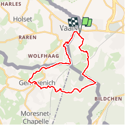
Tour Wandern von 13,1 km verfügbar auf Nordrhein-Westfalen, Städteregion Aachen, Aachen. Diese Tour wird von flip96 vorgeschlagen.
Beschreibung
Rondwandeling Vanuit Vaalserquartier, via 3 landenpunt, Gemmenich en door het Preuswald.
Mooie, korte wandeling door 3 landen.
Opmerkingen? flip96@home.nl
Ort
Land:
Germany
Region :
Nordrhein-Westfalen
Abteilung/Provinz :
Städteregion Aachen
Kommune :
Aachen
Standort:
Laurensberg
Gehen Sie:(Dec)
Gehen Sie:(UTM)
290400 ; 5628296 (32U) N.
Kommentare
Touren in der Umgebung
![Tour Wandern Vaals - 2023-04-07_19h11m12_788 - Photo](https://media.geolcdn.com/t/375/260/ext.jpg?maxdim=2&url=https%3A%2F%2Fmedia.geolcdn.com%2Ff%2Fbd8f5c72-b581-4e46-b6f7-9a77fca5b16a.jpg)
![Wandern Wandern](https://static1.geolcdn.com/sitytour/trail-icons/101.png)
2023-04-07_19h11m12_788
Wandern
Medium
(1)
Vaals,
Limburg,
Unbekannt,
Netherlands
![](/images/other/stat-length.png)
12,9 km | 16,3 km-effort
3h 42min
![](https://static1.geolcdn.com/siteimages/upload/files/16400158638029165_repeat_loop_refresh_sync_direction_icon.png)
Ja
![Tour Wandern Vaals - 2023-04-07_19h07m33_235 - Photo](https://media.geolcdn.com/t/375/260/ext.jpg?maxdim=2&url=https%3A%2F%2Fmedia.geolcdn.com%2Ff%2F2b2b6b31-a826-484c-a3a8-d4c3abde9549.jpg)
![Wandern Wandern](https://static1.geolcdn.com/sitytour/trail-icons/101.png)
2023-04-07_19h07m33_235
Wandern
Medium
(1)
Vaals,
Limburg,
Unbekannt,
Netherlands
![](/images/other/stat-length.png)
14,7 km | 18,3 km-effort
4h 9min
![](https://static1.geolcdn.com/siteimages/upload/files/16400158638029165_repeat_loop_refresh_sync_direction_icon.png)
Ja
![Tour Wandern Aachen - Aix-la-Chapelle - Photo](https://media.geolcdn.com/t/375/260/ext.jpg?maxdim=2&url=https%3A%2F%2Fmedia.geolcdn.com%2Ff%2F19678e47-68ef-4997-bad3-67eb75fafd82.jpg)
![Wandern Wandern](https://static1.geolcdn.com/sitytour/trail-icons/101.png)
Aix-la-Chapelle
Wandern
Einfach
(1)
Aachen,
Nordrhein-Westfalen,
Städteregion Aachen,
Germany
![](/images/other/stat-length.png)
11,4 km | 15,4 km-effort
3h 30min
![](https://static1.geolcdn.com/siteimages/upload/files/16400158638029165_repeat_loop_refresh_sync_direction_icon.png)
Ja
![Tour Wandern Aachen - Aix-la-Chapelle - Photo](https://media.geolcdn.com/t/375/260/ext.jpg?maxdim=2&url=https%3A%2F%2Fmedia.geolcdn.com%2Ff%2Fefbe95f3-eeed-42aa-9acc-74aad4d18b78.jpg)
![Wandern Wandern](https://static1.geolcdn.com/sitytour/trail-icons/101.png)
Aix-la-Chapelle
Wandern
Einfach
(1)
Aachen,
Nordrhein-Westfalen,
Städteregion Aachen,
Germany
![](/images/other/stat-length.png)
11,1 km | 13,4 km-effort
3h 2min
![](https://static1.geolcdn.com/siteimages/upload/files/16400158638029165_repeat_loop_refresh_sync_direction_icon.png)
Ja
![Tour Wandern Vaals - 2022-11-11_17h47m43_wandelroute---cittaslow-rondje-viele - Photo](https://media.geolcdn.com/t/375/260/ext.jpg?maxdim=2&url=https%3A%2F%2Fmedia.geolcdn.com%2Ff%2Fcb720190-f2d4-42d1-99cb-3f9826e2bd6a.jpg)
![Wandern Wandern](https://static1.geolcdn.com/sitytour/trail-icons/101.png)
2022-11-11_17h47m43_wandelroute---cittaslow-rondje-viele
Wandern
Medium
(1)
Vaals,
Limburg,
Unbekannt,
Netherlands
![](/images/other/stat-length.png)
12,8 km | 17,1 km-effort
3h 53min
![](https://static1.geolcdn.com/siteimages/upload/files/16400158638029165_repeat_loop_refresh_sync_direction_icon.png)
Ja
![Tour Wandern Vaals - 2021-07-14_08h55m00_1431 - Photo](https://media.geolcdn.com/t/375/260/ext.jpg?maxdim=2&url=https%3A%2F%2Fmedia.geolcdn.com%2Ff%2Fbe698cb8-a234-4803-8ecd-dfa4be54f61b.jpg)
![Wandern Wandern](https://static1.geolcdn.com/sitytour/trail-icons/101.png)
2021-07-14_08h55m00_1431
Wandern
Medium
(1)
Vaals,
Limburg,
Unbekannt,
Netherlands
![](/images/other/stat-length.png)
13,1 km | 16,6 km-effort
3h 46min
![](https://static1.geolcdn.com/siteimages/upload/files/16400158638029165_repeat_loop_refresh_sync_direction_icon.png)
Ja
![Tour Wandern Kelmis - 20200730 - Les 3 Bornes 7.3 Km - Photo](https://media.geolcdn.com/t/375/260/ext.jpg?maxdim=2&url=https%3A%2F%2Fmedia.geolcdn.com%2Ff%2Fab7b3f98-4235-4a73-ba70-1bedd5c785f3.jpg)
![Wandern Wandern](https://static1.geolcdn.com/sitytour/trail-icons/101.png)
20200730 - Les 3 Bornes 7.3 Km
Wandern
Schwierig
(1)
Kelmis,
Wallonien,
Lüttich,
Belgium
![](/images/other/stat-length.png)
7,4 km | 10,4 km-effort
1h 50min
![](https://static1.geolcdn.com/siteimages/upload/files/16400158638029165_repeat_loop_refresh_sync_direction_icon.png)
Ja
![Tour Wandern Kelmis - Venn Trilogie (1er étape) - Photo](https://media.geolcdn.com/t/375/260/ext.jpg?maxdim=2&url=https%3A%2F%2Fmedia.geolcdn.com%2Ff%2F1309a595-2e15-4d31-9259-ac0f30e3e1c8.jpg)
![Wandern Wandern](https://static1.geolcdn.com/sitytour/trail-icons/101.png)
Venn Trilogie (1er étape)
Wandern
Medium
(1)
Kelmis,
Wallonien,
Lüttich,
Belgium
![](/images/other/stat-length.png)
25 km | 30 km-effort
5h 0min
![](https://static1.geolcdn.com/siteimages/upload/files/16400158638029165_repeat_loop_refresh_sync_direction_icon.png)
Nein
![Tour Wandern Bleiberg - Promenade du Vieux Moulin (9,5km) - Photo](https://media.geolcdn.com/t/375/260/ext.jpg?maxdim=2&url=https%3A%2F%2Fstatic1.geolcdn.com%2Fsiteimages%2Fupload%2Ffiles%2F1553511878bg_sport_marche.png)
![Wandern Wandern](https://static1.geolcdn.com/sitytour/trail-icons/101.png)
Promenade du Vieux Moulin (9,5km)
Wandern
Sehr leicht
(2)
Bleiberg,
Wallonien,
Lüttich,
Belgium
![](/images/other/stat-length.png)
8,3 km | 11 km-effort
Unbekannt
![](https://static1.geolcdn.com/siteimages/upload/files/16400158638029165_repeat_loop_refresh_sync_direction_icon.png)
Ja