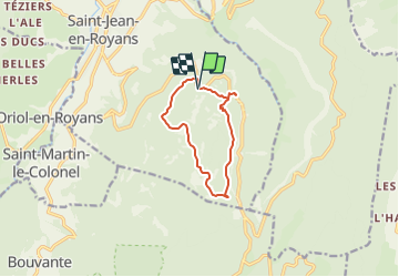
![](/images/other/stat-length.png)
![Tour Wandern Saint-Jean-en-Royans - SityTrail - Tour de l'echarasson avec description - Photo](https://media.geolcdn.com/t/1900/400/ext.pjpeg?maxdim=2&url=https%3A%2F%2Fstatic1.geolcdn.com%2Fsiteimages%2Fupload%2Ffiles%2F1553511878bg_sport_marche.png)
SityTrail - Tour de l'echarasson avec description
Djac
Benutzer
![Länge](/images/other/stat-length.png)
![Maximale Höhe](https://static1.geolcdn.com/siteimages/upload/files/1508320355ic_sort_altitude_max_24dp.png)
![Positive Höhendifferenz](https://static1.geolcdn.com/siteimages/upload/files/1508320355ic_sort_den_pos_24dp.png)
![Km-Effort](/images/other/stat-length.png)
![Min. Höhe](https://static1.geolcdn.com/siteimages/upload/files/1508320355ic_sort_altitude_min_24dp.png)
![Negative Höhendifferenz](https://static1.geolcdn.com/siteimages/upload/files/1508320355ic_sort_den_neg_24dp.png)
![Boucle](https://static1.geolcdn.com/siteimages/upload/files/16400158638029165_repeat_loop_refresh_sync_direction_icon.png)
![Wandern](https://static1.geolcdn.com/sitytour/trail-icons/101.png)
3h27
Schwierigkeit : Schwierig
![Scannen Sie diesen QR-Code, um die Tour in der SityTrail-Anwendung zu öffnen](https://capi.geolives.com/qq0zvz2zws4bq2lad0pu/sitytour/trails/2339816/qr.png?size=200)
Kostenlosegpshiking-Anwendung
Über SityTrail
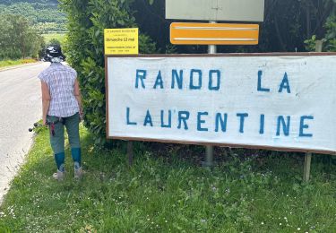
Tour Wandern von 9,2 km verfügbar auf Auvergne-Rhone-Alpen, Drôme, Saint-Jean-en-Royans. Diese Tour wird von Djac vorgeschlagen.
Beschreibung
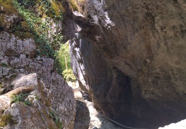
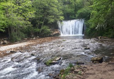
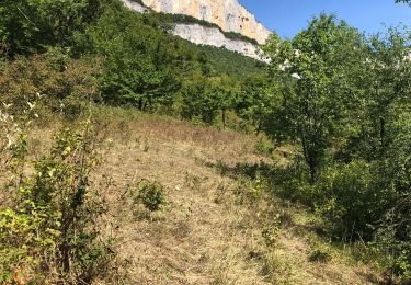
Très jolie randonnée qui permettra d'avoir de belles vues sur Combe laval. Un petit détour permettra de voir le col de la Machine et la vue imposante sur les Grands Goulets (attention pas de marquage, et une bonne descente).
Cette randonnée vous fera découvrir les différentes essences d'arbres du vercors.
Parfois le trajet ne suis pas vraiment la carte IGN, il faut bien suivre le balisage jaune et vert.
Cette randonnée ne presente aucune difficulté majeure.
Ort
Kommentare
Touren in der Umgebung
![Tour Wandern Saint-Laurent-en-Royans - 26 rocher des mines ARP - Photo](https://media.geolcdn.com/t/375/260/bd4f581f-b362-467f-a5ca-afa55317a017.jpg&format=jpg&maxdim=2)
![Wandern Wandern](https://static1.geolcdn.com/sitytour/trail-icons/101.png)
Wandern
![](/images/other/stat-length.png)
![](https://static1.geolcdn.com/siteimages/upload/files/16400158638029165_repeat_loop_refresh_sync_direction_icon.png)
![Tour Wandern Sainte-Eulalie-en-Royans - 26 ste eulalie - Photo](https://media.geolcdn.com/t/375/260/cc17d7c1-039b-4811-aa20-433bfbe37107.jpg&format=jpg&maxdim=2)
![Wandern Wandern](https://static1.geolcdn.com/sitytour/trail-icons/101.png)
Wandern
![](/images/other/stat-length.png)
![](https://static1.geolcdn.com/siteimages/upload/files/16400158638029165_repeat_loop_refresh_sync_direction_icon.png)
![Tour Wandern Bouvante - 26 gorges lyonne 23.08.23 - Photo](https://media.geolcdn.com/t/375/260/870074ef-5a15-4ee6-8281-67eb9d6cd365.jpg&format=jpg&maxdim=2)
![Wandern Wandern](https://static1.geolcdn.com/sitytour/trail-icons/101.png)
Wandern
![](/images/other/stat-length.png)
![](https://static1.geolcdn.com/siteimages/upload/files/16400158638029165_repeat_loop_refresh_sync_direction_icon.png)
![Tour Wandern Bouvante - 26 val ste marie - Photo](https://media.geolcdn.com/t/375/260/f2d22436-2d05-4a48-ba4c-5de578a7a580.jpg&format=jpg&maxdim=2)
![Wandern Wandern](https://static1.geolcdn.com/sitytour/trail-icons/101.png)
Wandern
![](/images/other/stat-length.png)
![](https://static1.geolcdn.com/siteimages/upload/files/16400158638029165_repeat_loop_refresh_sync_direction_icon.png)
![Tour Wandern Oriol-en-Royans - 26 pas de l écho - Photo](https://media.geolcdn.com/t/375/260/ac202026-42b8-42ae-9ed4-0d1c52688ae8.jpg&format=jpg&maxdim=2)
![Wandern Wandern](https://static1.geolcdn.com/sitytour/trail-icons/101.png)
Wandern
![](/images/other/stat-length.png)
![](https://static1.geolcdn.com/siteimages/upload/files/16400158638029165_repeat_loop_refresh_sync_direction_icon.png)
![Tour Wandern Bouvante - 26 tour Val ste marie bouvante 10 6 21 - Photo](https://media.geolcdn.com/t/375/260/b75a5e14-c2ec-4fc7-8531-278c44c9cb32.jpg&format=jpg&maxdim=2)
![Wandern Wandern](https://static1.geolcdn.com/sitytour/trail-icons/101.png)
Wandern
![](/images/other/stat-length.png)
![](https://static1.geolcdn.com/siteimages/upload/files/16400158638029165_repeat_loop_refresh_sync_direction_icon.png)
![Tour sport Saint-Laurent-en-Royans - St Laurent en Royans. La Laurentine - Photo](https://media.geolcdn.com/t/375/260/19b70eea-b54e-4263-823b-d99859d9e399.jpg&format=jpg&maxdim=2)
sport
![](/images/other/stat-length.png)
![](https://static1.geolcdn.com/siteimages/upload/files/16400158638029165_repeat_loop_refresh_sync_direction_icon.png)
![Tour Nordic Walking Saint-Laurent-en-Royans - Circuit entre Saint-Laurent-en-Royans et Pont-en-Royans - Photo](https://media.geolcdn.com/t/375/260/e35cab6e-ed35-4b24-b3a9-4e25ca3d2169.jpg&format=jpg&maxdim=2)
![Nordic Walking Nordic Walking](https://static1.geolcdn.com/sitytour/trail-icons/102.png)
Nordic Walking
![](/images/other/stat-length.png)
![](https://static1.geolcdn.com/siteimages/upload/files/16400158638029165_repeat_loop_refresh_sync_direction_icon.png)
![Tour Wandern Saint-Laurent-en-Royans - Tour de Combe Laval - Photo](https://media.geolcdn.com/t/375/260/9972e809-7238-47c2-ad32-ff5f48f040f2.jpg&format=jpg&maxdim=2)
![Wandern Wandern](https://static1.geolcdn.com/sitytour/trail-icons/101.png)
Wandern
![](/images/other/stat-length.png)
![](https://static1.geolcdn.com/siteimages/upload/files/16400158638029165_repeat_loop_refresh_sync_direction_icon.png)