


hastings

gerardprovost
Benutzer
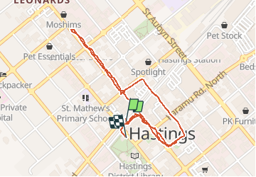

Länge
2,8 km

Maximale Höhe
18 m

Positive Höhendifferenz
10 m
Km-Effort
2,9 km

Min. Höhe
14 m

Negative Höhendifferenz
8 m
Boucle
Ja
Erstellungsdatum :
2020-02-15 03:02:57.145
Letzte Änderung :
2020-02-16 03:18:42.852
54m
Schwierigkeit : Sehr leicht

Kostenlosegpshiking-Anwendung
 SityTrail
IGN / Geografische Institute
SityTrail World
Die Welt öffnet sich für Sie
Über SityTrail
Tour Rennrad von 2,8 km verfügbar auf Hawke's Bay, Hastings District. Diese Tour wird von gerardprovost vorgeschlagen.
Ort
Land:
New Zealand
Region :
Hawke's Bay
Abteilung/Provinz :
Hastings District
Kommune :
Hastings
Standort:
Unknown
Gehen Sie:(Dec)
Gehen Sie:(UTM)
486492 ; 5611916 (60H) S.
Kommentare
Touren in der Umgebung