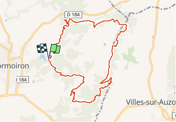
![](/images/other/stat-length.png)
![Tour Wandern Mormoiron - LAC DES SALETTES LES OCRES MORMOIRON - Photo](https://media.geolcdn.com/t/1900/400/ebbcce84-e946-4807-bb7f-1cc6e747e610.jpg&format=pjpeg&maxdim=2)
LAC DES SALETTES LES OCRES MORMOIRON
FLORENSAC
Benutzer
![Länge](/images/other/stat-length.png)
![Maximale Höhe](https://static1.geolcdn.com/siteimages/upload/files/1508320355ic_sort_altitude_max_24dp.png)
![Positive Höhendifferenz](https://static1.geolcdn.com/siteimages/upload/files/1508320355ic_sort_den_pos_24dp.png)
![Km-Effort](/images/other/stat-length.png)
![Min. Höhe](https://static1.geolcdn.com/siteimages/upload/files/1508320355ic_sort_altitude_min_24dp.png)
![Negative Höhendifferenz](https://static1.geolcdn.com/siteimages/upload/files/1508320355ic_sort_den_neg_24dp.png)
![Boucle](https://static1.geolcdn.com/siteimages/upload/files/16400158638029165_repeat_loop_refresh_sync_direction_icon.png)
![Wandern](https://static1.geolcdn.com/sitytour/trail-icons/101.png)
5h13
Schwierigkeit : Einfach
![Scannen Sie diesen QR-Code, um die Tour in der SityTrail-Anwendung zu öffnen](https://capi.geolives.com/qq0zvz2zws4bq2lad0pu/sitytour/trails/2330256/qr.png?size=200)
Kostenlosegpshiking-Anwendung
Über SityTrail
Tour Wandern von 12,2 km verfügbar auf Provence-Alpes-Côte d'Azur, Vaucluse, Mormoiron. Diese Tour wird von FLORENSAC vorgeschlagen.
Beschreibung
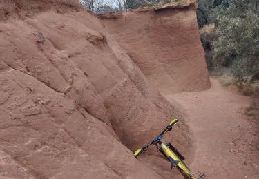
Une jolie randonnée tranquilou dans des sables de toutes les couleurs
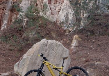
a environ 4.5 kms une sortie de canyon un peu raide
pour les téméraires continuer
pour les autres un passage sur la droite un peu moins pentu
on arrive sur le plateau( petit cabanon) pas loin de la route ou on se rejoint, continuer en suivant la trace
au km 10 ne pas hésiter à descendre dans la carrière puis remonter et reprendre le parcours
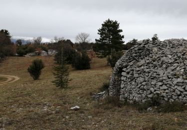
on n est pas passé devant les grottes qui sont pourtant a voir
on reviendra les faire une autre fois
Ort
Kommentare
Touren in der Umgebung
![Tour Wandern Villes-sur-Auzon - villes sur auzon - Photo](https://media.geolcdn.com/t/375/260/0e280ec1-76df-4cda-81c1-92933dd2eb5d.jpg&format=jpg&maxdim=2)
![Wandern Wandern](https://static1.geolcdn.com/sitytour/trail-icons/101.png)
Wandern
![](/images/other/stat-length.png)
![](https://static1.geolcdn.com/siteimages/upload/files/16400158638029165_repeat_loop_refresh_sync_direction_icon.png)
![Tour Wandern Mormoiron - Ballade for Friends - Photo](https://media.geolcdn.com/t/375/260/ext.jpg?maxdim=2&url=https%3A%2F%2Fstatic1.geolcdn.com%2Fsiteimages%2Fupload%2Ffiles%2F1553511878bg_sport_marche.png)
![Wandern Wandern](https://static1.geolcdn.com/sitytour/trail-icons/101.png)
Wandern
![](/images/other/stat-length.png)
![](https://static1.geolcdn.com/siteimages/upload/files/16400158638029165_repeat_loop_refresh_sync_direction_icon.png)
![Tour Wandern Mazan - pierres Sèches Mazan - Photo](https://media.geolcdn.com/t/375/260/ext.jpg?maxdim=2&url=https%3A%2F%2Fstatic1.geolcdn.com%2Fsiteimages%2Fupload%2Ffiles%2F1553511878bg_sport_marche.png)
![Wandern Wandern](https://static1.geolcdn.com/sitytour/trail-icons/101.png)
Wandern
![](/images/other/stat-length.png)
![](https://static1.geolcdn.com/siteimages/upload/files/16400158638029165_repeat_loop_refresh_sync_direction_icon.png)
![Tour Wandern Villes-sur-Auzon - LES ESCAMPEAUX - Photo](https://media.geolcdn.com/t/375/260/8e14f8aa-4eae-47ed-ac37-3fc4720c0e61.jpg&format=jpg&maxdim=2)
![Wandern Wandern](https://static1.geolcdn.com/sitytour/trail-icons/101.png)
Wandern
![](/images/other/stat-length.png)
![](https://static1.geolcdn.com/siteimages/upload/files/16400158638029165_repeat_loop_refresh_sync_direction_icon.png)
![Tour Mountainbike Mormoiron - One more time 🚴♂️🚴♀️🚴 - Photo](https://media.geolcdn.com/t/375/260/f3f6b427-22dc-427b-ba25-3201b8e8cf01.jpg&format=jpg&maxdim=2)
![Mountainbike Mountainbike](https://static1.geolcdn.com/sitytour/trail-icons/202.png)
Mountainbike
![](/images/other/stat-length.png)
![](https://static1.geolcdn.com/siteimages/upload/files/16400158638029165_repeat_loop_refresh_sync_direction_icon.png)
![Tour Mountainbike Mormoiron - Reco circuit Trail Ocres et Limons (avec variante !!!) - Photo](https://media.geolcdn.com/t/375/260/8f42caa2-02b8-414a-aa18-1c03ca335c98.jpg&format=jpg&maxdim=2)
![Mountainbike Mountainbike](https://static1.geolcdn.com/sitytour/trail-icons/202.png)
Mountainbike
![](/images/other/stat-length.png)
![](https://static1.geolcdn.com/siteimages/upload/files/16400158638029165_repeat_loop_refresh_sync_direction_icon.png)
![Tour Wandern Mormoiron - Balladounette d après fêtes 🥳 - Photo](https://media.geolcdn.com/t/375/260/ecd5d04a-a53f-4421-b56c-9619fa1eb2e3.jpg&format=jpg&maxdim=2)
![Wandern Wandern](https://static1.geolcdn.com/sitytour/trail-icons/101.png)
Wandern
![](/images/other/stat-length.png)
![](https://static1.geolcdn.com/siteimages/upload/files/16400158638029165_repeat_loop_refresh_sync_direction_icon.png)
![Tour Wandern Mormoiron - Old Single track - Photo](https://media.geolcdn.com/t/375/260/4c71c038-1cb7-40ac-b2e7-510d91db1d5b.jpg&format=jpg&maxdim=2)
![Wandern Wandern](https://static1.geolcdn.com/sitytour/trail-icons/101.png)
Wandern
![](/images/other/stat-length.png)
![](https://static1.geolcdn.com/siteimages/upload/files/16400158638029165_repeat_loop_refresh_sync_direction_icon.png)
![Tour Mountainbike Mormoiron - MTB Gravel in the Garden ...... - Photo](https://media.geolcdn.com/t/375/260/2c2d7a8e-eefe-454c-ab91-1d344156a1b6.jpg&format=jpg&maxdim=2)
![Mountainbike Mountainbike](https://static1.geolcdn.com/sitytour/trail-icons/202.png)
Mountainbike
![](/images/other/stat-length.png)
![](https://static1.geolcdn.com/siteimages/upload/files/16400158638029165_repeat_loop_refresh_sync_direction_icon.png)