![](/images/other/stat-length.png)
Trigance-Rancoumas
Sugg
Benutzer
![Länge](/images/other/stat-length.png)
Länge
14,6 km
![Maximale Höhe](https://static1.geolcdn.com/siteimages/upload/files/1508320355ic_sort_altitude_max_24dp.png)
Maximale Höhe
1156 m
![Positive Höhendifferenz](https://static1.geolcdn.com/siteimages/upload/files/1508320355ic_sort_den_pos_24dp.png)
Positive Höhendifferenz
602 m
![Km-Effort](/images/other/stat-length.png)
Km-Effort
23 km
![Min. Höhe](https://static1.geolcdn.com/siteimages/upload/files/1508320355ic_sort_altitude_min_24dp.png)
Min. Höhe
769 m
![Negative Höhendifferenz](https://static1.geolcdn.com/siteimages/upload/files/1508320355ic_sort_den_neg_24dp.png)
Negative Höhendifferenz
603 m
![Boucle](https://static1.geolcdn.com/siteimages/upload/files/16400158638029165_repeat_loop_refresh_sync_direction_icon.png)
Boucle
Ja
Erstellungsdatum :
2019-03-22 17:00:22.377
Letzte Änderung :
2019-03-22 17:00:22.502
![Wandern](https://static1.geolcdn.com/sitytour/trail-icons/101.png)
4h50
Schwierigkeit : Medium
![Scannen Sie diesen QR-Code, um die Tour in der SityTrail-Anwendung zu öffnen](https://capi.geolives.com/qq0zvz2zws4bq2lad0pu/sitytour/trails/232434/qr.png?size=200)
Kostenlosegpshiking-Anwendung
Über SityTrail
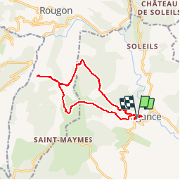
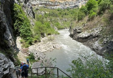
Tour Wandern von 14,6 km verfügbar auf Provence-Alpes-Côte d'Azur, Var, Trigance. Diese Tour wird von Sugg vorgeschlagen.
Beschreibung
RF : Jo Piquemal.
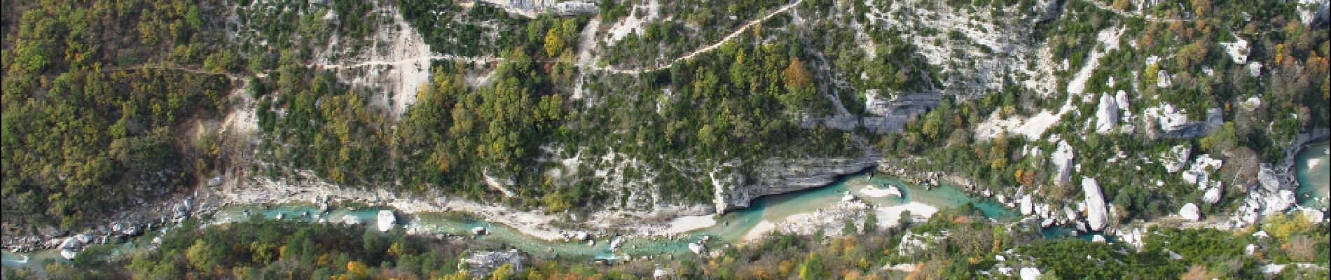
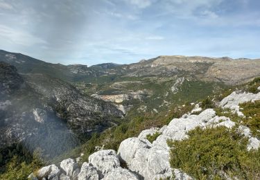
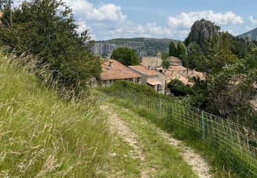
Magnifique rando au départ de Trigance jusqu'aux balcons de Rancoumas au dessus du Verdon.
Point de vue remarquable.
Un aller retour par le GR49 serait aussi sympa et laisserait plus de temps à Rancoumas car le parcours Nord n'est pas terrible !!!
Ort
Land:
France
Region :
Provence-Alpes-Côte d'Azur
Abteilung/Provinz :
Var
Kommune :
Trigance
Standort:
Unknown
Gehen Sie:(Dec)
Gehen Sie:(UTM)
294108 ; 4848462 (32T) N.
Kommentare
Touren in der Umgebung
![Tour Wandern Rougon - Gorges du Verdon - de Point Sublime vers Encastel - AR - Photo](https://media.geolcdn.com/t/375/260/ext.jpg?maxdim=2&url=https%3A%2F%2Fservices.sitytrail.com%2FGeolivesWS%2FDownloadMedia.ashx%3FTrailID%3D346532%26Media%3Dfix__20140919102850.jpg)
![Wandern Wandern](https://static1.geolcdn.com/sitytour/trail-icons/101.png)
Gorges du Verdon - de Point Sublime vers Encastel - AR
Wandern
Medium
(2)
Rougon,
Provence-Alpes-Côte d'Azur,
Alpes-de-Haute-Provence,
France
![](/images/other/stat-length.png)
9,3 km | 18,6 km-effort
3h 15min
![](https://static1.geolcdn.com/siteimages/upload/files/16400158638029165_repeat_loop_refresh_sync_direction_icon.png)
Ja
![Tour Wandern Rougon - Sentier Martel.Gorges du Verdon.06 05 16 - Photo](https://media.geolcdn.com/t/375/260/ext.jpg?maxdim=2&url=https%3A%2F%2Fservices.sitytrail.com%2FGeolivesWS%2FDownloadMedia.ashx%3FTrailID%3D565642%26Media%3Dfix__20160506150757.jpg)
![Wandern Wandern](https://static1.geolcdn.com/sitytour/trail-icons/101.png)
Sentier Martel.Gorges du Verdon.06 05 16
Wandern
Medium
(3)
Rougon,
Provence-Alpes-Côte d'Azur,
Alpes-de-Haute-Provence,
France
![](/images/other/stat-length.png)
12,1 km | 26 km-effort
6h 20min
![](https://static1.geolcdn.com/siteimages/upload/files/16400158638029165_repeat_loop_refresh_sync_direction_icon.png)
Nein
![Tour Wandern Trigance - Pont du Carajuan Rougon Pont du Tusset Belvédère de Rancoumas Trace réelle - Photo](https://media.geolcdn.com/t/375/260/0d9be621-f74c-4e9c-86b6-3e1c9c92569d.jpg&format=jpg&maxdim=2)
![Wandern Wandern](https://static1.geolcdn.com/sitytour/trail-icons/101.png)
Pont du Carajuan Rougon Pont du Tusset Belvédère de Rancoumas Trace réelle
Wandern
Sehr schwierig
Trigance,
Provence-Alpes-Côte d'Azur,
Var,
France
![](/images/other/stat-length.png)
21 km | 34 km-effort
7h 40min
![](https://static1.geolcdn.com/siteimages/upload/files/16400158638029165_repeat_loop_refresh_sync_direction_icon.png)
Ja
![Tour Wandern Trigance - Trigance : Rancoumas-Carajuan - Photo](https://media.geolcdn.com/t/375/260/05e6b860-df1f-428f-8277-8650dc3b7bdf.jpg&format=jpg&maxdim=2)
![Wandern Wandern](https://static1.geolcdn.com/sitytour/trail-icons/101.png)
Trigance : Rancoumas-Carajuan
Wandern
Medium
Trigance,
Provence-Alpes-Côte d'Azur,
Var,
France
![](/images/other/stat-length.png)
16,4 km | 26 km-effort
5h 53min
![](https://static1.geolcdn.com/siteimages/upload/files/16400158638029165_repeat_loop_refresh_sync_direction_icon.png)
Nein
![Tour Wandern Rougon - Mourre du chanier par rougon Réél - Photo](https://media.geolcdn.com/t/375/260/012183d2-9b95-47e6-8342-def03e6aa442.jpg&format=jpg&maxdim=2)
![Wandern Wandern](https://static1.geolcdn.com/sitytour/trail-icons/101.png)
Mourre du chanier par rougon Réél
Wandern
Sehr schwierig
Rougon,
Provence-Alpes-Côte d'Azur,
Alpes-de-Haute-Provence,
France
![](/images/other/stat-length.png)
18,7 km | 34 km-effort
7h 41min
![](https://static1.geolcdn.com/siteimages/upload/files/16400158638029165_repeat_loop_refresh_sync_direction_icon.png)
Ja
![Tour Wandern Rougon - Point sublime Verdon Blanc Martel 12 km - Photo](https://media.geolcdn.com/t/375/260/7151e3a3-b423-4b55-88c4-a120b42dbc2f.jpg&format=jpg&maxdim=2)
![Wandern Wandern](https://static1.geolcdn.com/sitytour/trail-icons/101.png)
Point sublime Verdon Blanc Martel 12 km
Wandern
Sehr schwierig
Rougon,
Provence-Alpes-Côte d'Azur,
Alpes-de-Haute-Provence,
France
![](/images/other/stat-length.png)
12,3 km | 24 km-effort
5h 32min
![](https://static1.geolcdn.com/siteimages/upload/files/16400158638029165_repeat_loop_refresh_sync_direction_icon.png)
Ja
![Tour Wandern Trigance - 2023-03-07 Belvédère des vautours - Photo](https://media.geolcdn.com/t/375/260/0d06071b-f845-42c2-8a64-fcf3d10e6149.jpg&format=jpg&maxdim=2)
![Wandern Wandern](https://static1.geolcdn.com/sitytour/trail-icons/101.png)
2023-03-07 Belvédère des vautours
Wandern
Medium
Trigance,
Provence-Alpes-Côte d'Azur,
Var,
France
![](/images/other/stat-length.png)
11,6 km | 17,6 km-effort
6h 18min
![](https://static1.geolcdn.com/siteimages/upload/files/16400158638029165_repeat_loop_refresh_sync_direction_icon.png)
Ja
![Tour Wandern Rougon - 2023-02-24 Pont de Tusset - Rancoumas - Entreverges - Photo](https://media.geolcdn.com/t/375/260/95d9c943-b4ce-4d81-89ff-82c5f7b78e7d.jpg&format=jpg&maxdim=2)
![Wandern Wandern](https://static1.geolcdn.com/sitytour/trail-icons/101.png)
2023-02-24 Pont de Tusset - Rancoumas - Entreverges
Wandern
Medium
Rougon,
Provence-Alpes-Côte d'Azur,
Alpes-de-Haute-Provence,
France
![](/images/other/stat-length.png)
10,8 km | 19,8 km-effort
6h 48min
![](https://static1.geolcdn.com/siteimages/upload/files/16400158638029165_repeat_loop_refresh_sync_direction_icon.png)
Ja
![Tour Wandern Trigance - Trigance, Pont de Sautet, Clue de Carejuan - Photo](https://media.geolcdn.com/t/375/260/1dc61dcc-3f4e-441d-8260-ccd5372d47f3.jpg&format=jpg&maxdim=2)
![Wandern Wandern](https://static1.geolcdn.com/sitytour/trail-icons/101.png)
Trigance, Pont de Sautet, Clue de Carejuan
Wandern
Sehr leicht
Trigance,
Provence-Alpes-Côte d'Azur,
Var,
France
![](/images/other/stat-length.png)
12,4 km | 18,3 km-effort
3h 2min
![](https://static1.geolcdn.com/siteimages/upload/files/16400158638029165_repeat_loop_refresh_sync_direction_icon.png)
Ja
pour moi le top vu le prix des cartes au 25\1000