


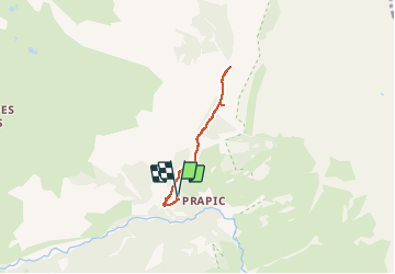


6,3 km | 9,9 km-effort

Benutzer


Kostenlosegpshiking-Anwendung
 SityTrail
IGN / Geografische Institute
SityTrail World
Die Welt öffnet sich für Sie
Tour Schneeschuhwandern von 4,9 km verfügbar auf Provence-Alpes-Côte d'Azur, Hochalpen, Orcières. Diese Tour wird von Marc Auger vorgeschlagen.
Randonnée raquette depuis le parking de Prapic aux cascades du torrent du Blaisil en passant par le tombeau du poète Joseph Reymond.
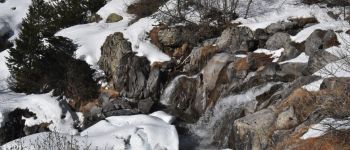
Suivant la température il est possible de voir les cascades en glace.


Wandern

Wandern

Wandern

Wandern

Skiwanderen

Wandern

Wandern

Skiwanderen

Skiwanderen