![](/images/other/stat-length.png)
![Tour Zu Fuß Estrablin - TL Crêtes d'estrablin - Photo](https://media.geolcdn.com/t/1900/400/ext.pjpeg?maxdim=2&url=https%3A%2F%2Fstatic1.geolcdn.com%2Fsiteimages%2Fupload%2Ffiles%2F1545311037marcheuse_200dpi.jpg)
TL Crêtes d'estrablin
Clubléorando
Benutzer
![Länge](/images/other/stat-length.png)
Länge
9,9 km
![Maximale Höhe](https://static1.geolcdn.com/siteimages/upload/files/1508320355ic_sort_altitude_max_24dp.png)
Maximale Höhe
352 m
![Positive Höhendifferenz](https://static1.geolcdn.com/siteimages/upload/files/1508320355ic_sort_den_pos_24dp.png)
Positive Höhendifferenz
171 m
![Km-Effort](/images/other/stat-length.png)
Km-Effort
12,2 km
![Min. Höhe](https://static1.geolcdn.com/siteimages/upload/files/1508320355ic_sort_altitude_min_24dp.png)
Min. Höhe
215 m
![Negative Höhendifferenz](https://static1.geolcdn.com/siteimages/upload/files/1508320355ic_sort_den_neg_24dp.png)
Negative Höhendifferenz
173 m
![Boucle](https://static1.geolcdn.com/siteimages/upload/files/16400158638029165_repeat_loop_refresh_sync_direction_icon.png)
Boucle
Ja
Erstellungsdatum :
2020-01-29 11:30:06.023
Letzte Änderung :
2023-02-24 16:47:22.601
![Zu Fuß](https://static1.geolcdn.com/sitytour/trail-icons/100.png)
3h30
Schwierigkeit : Einfach
![Scannen Sie diesen QR-Code, um die Tour in der SityTrail-Anwendung zu öffnen](https://capi.geolives.com/qq0zvz2zws4bq2lad0pu/sitytour/trails/2318459/qr.png?size=200)
Kostenlosegpshiking-Anwendung
Über SityTrail
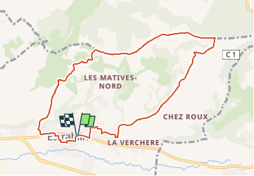
Tour Zu Fuß von 9,9 km verfügbar auf Auvergne-Rhone-Alpen, Isère, Estrablin. Diese Tour wird von Clubléorando vorgeschlagen.
Beschreibung
Balade en boucle au départ du parking centre du village d'Estrablin. prendre le sentier direction nord est puis retour par les Matives nord
POIs
Ort
Land:
France
Region :
Auvergne-Rhone-Alpen
Abteilung/Provinz :
Isère
Kommune :
Estrablin
Standort:
Unknown
Gehen Sie:(Dec)
Gehen Sie:(UTM)
653498 ; 5042209 (31T) N.
Kommentare
Touren in der Umgebung
![Tour Zu Fuß Jardin - Jardin - 10,7 km - 255 m de dénivelé - 3h30 - Photo](https://media.geolcdn.com/t/375/260/ext.jpg?maxdim=2&url=https%3A%2F%2Fstatic1.geolcdn.com%2Fsiteimages%2Fupload%2Ffiles%2F1545311037marcheuse_200dpi.jpg)
![Zu Fuß Zu Fuß](https://static1.geolcdn.com/sitytour/trail-icons/100.png)
Jardin - 10,7 km - 255 m de dénivelé - 3h30
Zu Fuß
Medium
(1)
Jardin,
Auvergne-Rhone-Alpen,
Isère,
France
![](/images/other/stat-length.png)
10,7 km | 14,1 km-effort
3h 30min
![](https://static1.geolcdn.com/siteimages/upload/files/16400158638029165_repeat_loop_refresh_sync_direction_icon.png)
Ja
![Tour Mountainbike Serpaize - canyon de Serpaize - Photo](https://media.geolcdn.com/t/375/260/ext.jpg?maxdim=2&url=https%3A%2F%2Fstatic1.geolcdn.com%2Fsiteimages%2Fupload%2Ffiles%2F1524743154velo.jpg)
![Mountainbike Mountainbike](https://static1.geolcdn.com/sitytour/trail-icons/202.png)
canyon de Serpaize
Mountainbike
Einfach
(1)
Serpaize,
Auvergne-Rhone-Alpen,
Isère,
France
![](/images/other/stat-length.png)
13,4 km | 16,8 km-effort
1h 46min
![](https://static1.geolcdn.com/siteimages/upload/files/16400158638029165_repeat_loop_refresh_sync_direction_icon.png)
Ja
![Tour Rennrad Pont-Évêque - Pont-Évêque 47km - Photo](https://media.geolcdn.com/t/375/260/f6a8b920-25cb-431a-8ca0-51204302ebe0.jpeg&format=jpg&maxdim=2)
![Rennrad Rennrad](https://static1.geolcdn.com/sitytour/trail-icons/201.png)
Pont-Évêque 47km
Rennrad
Sehr schwierig
Pont-Évêque,
Auvergne-Rhone-Alpen,
Isère,
France
![](/images/other/stat-length.png)
47 km | 56 km-effort
3h 23min
![](https://static1.geolcdn.com/siteimages/upload/files/16400158638029165_repeat_loop_refresh_sync_direction_icon.png)
Ja
![Tour Wandern Moidieu-Détourbe - 38 Moidieu Detourbe court 16km 300m - Photo](https://media.geolcdn.com/t/375/260/2e446041-4bb7-4cbf-9625-1e1122dbd165.jpg&format=jpg&maxdim=2)
![Wandern Wandern](https://static1.geolcdn.com/sitytour/trail-icons/101.png)
38 Moidieu Detourbe court 16km 300m
Wandern
Einfach
Moidieu-Détourbe,
Auvergne-Rhone-Alpen,
Isère,
France
![](/images/other/stat-length.png)
16,1 km | 20 km-effort
4h 39min
![](https://static1.geolcdn.com/siteimages/upload/files/16400158638029165_repeat_loop_refresh_sync_direction_icon.png)
Ja
![Tour Zu Fuß Eyzin-Pinet - Eyzin Pinet - château Pinet - 11 km - 298 m de dénivelé - 4h - Photo](https://media.geolcdn.com/t/375/260/ext.jpg?maxdim=2&url=https%3A%2F%2Fstatic1.geolcdn.com%2Fsiteimages%2Fupload%2Ffiles%2F1545311037marcheuse_200dpi.jpg)
![Zu Fuß Zu Fuß](https://static1.geolcdn.com/sitytour/trail-icons/100.png)
Eyzin Pinet - château Pinet - 11 km - 298 m de dénivelé - 4h
Zu Fuß
Medium
Eyzin-Pinet,
Auvergne-Rhone-Alpen,
Isère,
France
![](/images/other/stat-length.png)
11 km | 15 km-effort
4h 0min
![](https://static1.geolcdn.com/siteimages/upload/files/16400158638029165_repeat_loop_refresh_sync_direction_icon.png)
Ja
![Tour Wandern Serpaize - Serpaize_10,6km_d220m - Photo](https://media.geolcdn.com/t/375/260/ext.jpg?maxdim=2&url=https%3A%2F%2Fstatic1.geolcdn.com%2Fsiteimages%2Fupload%2Ffiles%2F1553511878bg_sport_marche.png)
![Wandern Wandern](https://static1.geolcdn.com/sitytour/trail-icons/101.png)
Serpaize_10,6km_d220m
Wandern
Einfach
(1)
Serpaize,
Auvergne-Rhone-Alpen,
Isère,
France
![](/images/other/stat-length.png)
4,5 km | 6 km-effort
1h 20min
![](https://static1.geolcdn.com/siteimages/upload/files/16400158638029165_repeat_loop_refresh_sync_direction_icon.png)
Ja
![Tour Zu Fuß Jardin - Vienne est - Bérardier - la Rosière - 10,20 km - 214 m de dénivelé - 3h - Photo](https://media.geolcdn.com/t/375/260/ext.jpg?maxdim=2&url=https%3A%2F%2Fstatic1.geolcdn.com%2Fsiteimages%2Fupload%2Ffiles%2F1545311037marcheuse_200dpi.jpg)
![Zu Fuß Zu Fuß](https://static1.geolcdn.com/sitytour/trail-icons/100.png)
Vienne est - Bérardier - la Rosière - 10,20 km - 214 m de dénivelé - 3h
Zu Fuß
Einfach
Jardin,
Auvergne-Rhone-Alpen,
Isère,
France
![](/images/other/stat-length.png)
10,2 km | 13,1 km-effort
3h 0min
![](https://static1.geolcdn.com/siteimages/upload/files/16400158638029165_repeat_loop_refresh_sync_direction_icon.png)
Ja
![Tour Zu Fuß Jardin - Jardin - 9,6 km - 223 m de dénivelé - 3h - Photo](https://media.geolcdn.com/t/375/260/ext.jpg?maxdim=2&url=https%3A%2F%2Fstatic1.geolcdn.com%2Fsiteimages%2Fupload%2Ffiles%2F1545311037marcheuse_200dpi.jpg)
![Zu Fuß Zu Fuß](https://static1.geolcdn.com/sitytour/trail-icons/100.png)
Jardin - 9,6 km - 223 m de dénivelé - 3h
Zu Fuß
Einfach
Jardin,
Auvergne-Rhone-Alpen,
Isère,
France
![](/images/other/stat-length.png)
9,6 km | 12,6 km-effort
3h 0min
![](https://static1.geolcdn.com/siteimages/upload/files/16400158638029165_repeat_loop_refresh_sync_direction_icon.png)
Ja
![Tour Zu Fuß Jardin - Jardin 21 JCB- 10 km - 229 m de dénivelé - 3h - Photo](https://media.geolcdn.com/t/375/260/ext.jpg?maxdim=2&url=https%3A%2F%2Fstatic1.geolcdn.com%2Fsiteimages%2Fupload%2Ffiles%2F1545311037marcheuse_200dpi.jpg)
![Zu Fuß Zu Fuß](https://static1.geolcdn.com/sitytour/trail-icons/100.png)
Jardin 21 JCB- 10 km - 229 m de dénivelé - 3h
Zu Fuß
Einfach
Jardin,
Auvergne-Rhone-Alpen,
Isère,
France
![](/images/other/stat-length.png)
10 km | 13 km-effort
3h 0min
![](https://static1.geolcdn.com/siteimages/upload/files/16400158638029165_repeat_loop_refresh_sync_direction_icon.png)
Ja