![](/images/other/stat-length.png)
![Tour Wandern Maurepas - marche du 16 janvier 2020 - Photo](https://media.geolcdn.com/t/1900/400/ext.pjpeg?maxdim=2&url=https%3A%2F%2Fstatic1.geolcdn.com%2Fsiteimages%2Fupload%2Ffiles%2F1553511878bg_sport_marche.png)
marche du 16 janvier 2020
jimch58
Benutzer
![Länge](/images/other/stat-length.png)
Länge
7,7 km
![Maximale Höhe](https://static1.geolcdn.com/siteimages/upload/files/1508320355ic_sort_altitude_max_24dp.png)
Maximale Höhe
178 m
![Positive Höhendifferenz](https://static1.geolcdn.com/siteimages/upload/files/1508320355ic_sort_den_pos_24dp.png)
Positive Höhendifferenz
111 m
![Km-Effort](/images/other/stat-length.png)
Km-Effort
9,2 km
![Min. Höhe](https://static1.geolcdn.com/siteimages/upload/files/1508320355ic_sort_altitude_min_24dp.png)
Min. Höhe
112 m
![Negative Höhendifferenz](https://static1.geolcdn.com/siteimages/upload/files/1508320355ic_sort_den_neg_24dp.png)
Negative Höhendifferenz
111 m
![Boucle](https://static1.geolcdn.com/siteimages/upload/files/16400158638029165_repeat_loop_refresh_sync_direction_icon.png)
Boucle
Ja
Erstellungsdatum :
2020-01-16 07:45:01.959
Letzte Änderung :
2020-01-16 11:04:53.115
![Wandern](https://static1.geolcdn.com/sitytour/trail-icons/101.png)
2h07
Schwierigkeit : Sehr leicht
![Scannen Sie diesen QR-Code, um die Tour in der SityTrail-Anwendung zu öffnen](https://capi.geolives.com/qq0zvz2zws4bq2lad0pu/sitytour/trails/2306664/qr.png?size=200)
Kostenlosegpshiking-Anwendung
Über SityTrail
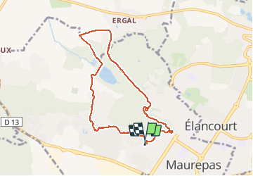
Tour Wandern von 7,7 km verfügbar auf Île-de-France, Yvelines, Maurepas. Diese Tour wird von jimch58 vorgeschlagen.
Beschreibung
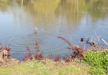
Par le ru de Maurepas puis sur le plateau dans le Bois, vers la Picterie ; retour par la Courance, Saint-Sauveur et les Rigoles Royales
Ort
Land:
France
Region :
Île-de-France
Abteilung/Provinz :
Yvelines
Kommune :
Maurepas
Standort:
Unknown
Gehen Sie:(Dec)
Gehen Sie:(UTM)
421609 ; 5401873 (31U) N.
Kommentare
Touren in der Umgebung
![Tour Wandern Lévis-Saint-Nom - _Le Vallon du Pommeret - Photo](https://media.geolcdn.com/t/375/260/ext.jpg?maxdim=2&url=https%3A%2F%2Fservices.sitytrail.com%2FGeolivesWS%2FDownloadMedia.ashx%3FTrailID%3D172087%26Media%3D296168f6-bac5-406d-9015-aae13e393b5e.jpg)
![Wandern Wandern](https://static1.geolcdn.com/sitytour/trail-icons/101.png)
_Le Vallon du Pommeret
Wandern
Einfach
(11)
Lévis-Saint-Nom,
Île-de-France,
Yvelines,
France
![](/images/other/stat-length.png)
6,3 km | 8 km-effort
1h 30min
![](https://static1.geolcdn.com/siteimages/upload/files/16400158638029165_repeat_loop_refresh_sync_direction_icon.png)
Ja
![Tour Wandern Le Mesnil-Saint-Denis - _Entre ancienne châtellenie et Ville nouvelle - Photo](https://media.geolcdn.com/t/375/260/ext.jpg?maxdim=2&url=https%3A%2F%2Fservices.sitytrail.com%2FGeolivesWS%2FDownloadMedia.ashx%3FTrailID%3D754427%26Media%3D98bcb1fa-3e08-461c-9cfd-0202e71bacca.png)
![Wandern Wandern](https://static1.geolcdn.com/sitytour/trail-icons/101.png)
_Entre ancienne châtellenie et Ville nouvelle
Wandern
Einfach
(1)
Le Mesnil-Saint-Denis,
Île-de-France,
Yvelines,
France
![](/images/other/stat-length.png)
8,6 km | 9,5 km-effort
2h 30min
![](https://static1.geolcdn.com/siteimages/upload/files/16400158638029165_repeat_loop_refresh_sync_direction_icon.png)
Ja
![Tour Wandern Lévis-Saint-Nom - _L'Yvette - Photo](https://media.geolcdn.com/t/375/260/ext.jpg?maxdim=2&url=https%3A%2F%2Fservices.sitytrail.com%2FGeolivesWS%2FDownloadMedia.ashx%3FTrailID%3D791900%26Media%3D1a0fab6c-bee3-420c-863c-ba0cc33379bb.JPG)
![Wandern Wandern](https://static1.geolcdn.com/sitytour/trail-icons/101.png)
_L'Yvette
Wandern
Einfach
(4)
Lévis-Saint-Nom,
Île-de-France,
Yvelines,
France
![](/images/other/stat-length.png)
5,2 km | 7 km-effort
1h 29min
![](https://static1.geolcdn.com/siteimages/upload/files/16400158638029165_repeat_loop_refresh_sync_direction_icon.png)
Ja
![Tour Wandern Le Tremblay-sur-Mauldre - rando du 12/03/2015 - Photo](https://media.geolcdn.com/t/375/260/ext.jpg?maxdim=2&url=https%3A%2F%2Fservices.sitytrail.com%2FGeolivesWS%2FDownloadMedia.ashx%3FTrailID%3D394961%26Media%3Dfix__20150312095010.jpg)
![Wandern Wandern](https://static1.geolcdn.com/sitytour/trail-icons/101.png)
rando du 12/03/2015
Wandern
Einfach
(1)
Le Tremblay-sur-Mauldre,
Île-de-France,
Yvelines,
France
![](/images/other/stat-length.png)
7,1 km | 9,3 km-effort
1h 59min
![](https://static1.geolcdn.com/siteimages/upload/files/16400158638029165_repeat_loop_refresh_sync_direction_icon.png)
Ja
![Tour Wandern Lévis-Saint-Nom - _Girouard - Photo](https://media.geolcdn.com/t/375/260/ext.jpg?maxdim=2&url=https%3A%2F%2Fservices.sitytrail.com%2FGeolivesWS%2FDownloadMedia.ashx%3FTrailID%3D780030%26Media%3D8e4fcc4d-bb49-4df5-bb6a-04111d08aa50.jpg)
![Wandern Wandern](https://static1.geolcdn.com/sitytour/trail-icons/101.png)
_Girouard
Wandern
Medium
(1)
Lévis-Saint-Nom,
Île-de-France,
Yvelines,
France
![](/images/other/stat-length.png)
8 km | 10 km-effort
2h 0min
![](https://static1.geolcdn.com/siteimages/upload/files/16400158638029165_repeat_loop_refresh_sync_direction_icon.png)
Ja
![Tour Zu Fuß Le Mesnil-Saint-Denis - Liaison douce le Mesnil - Cheuvreuse - Photo](https://media.geolcdn.com/t/375/260/fe0b08ae-f715-4ba6-a19f-cfaeaa2beefd.jpeg&format=jpg&maxdim=2)
![Zu Fuß Zu Fuß](https://static1.geolcdn.com/sitytour/trail-icons/100.png)
Liaison douce le Mesnil - Cheuvreuse
Zu Fuß
Einfach
Le Mesnil-Saint-Denis,
Île-de-France,
Yvelines,
France
![](/images/other/stat-length.png)
9,1 km | 10,4 km-effort
2h 22min
![](https://static1.geolcdn.com/siteimages/upload/files/16400158638029165_repeat_loop_refresh_sync_direction_icon.png)
Nein
![Tour Mountainbike Élancourt - VTT elancourt - Photo](https://media.geolcdn.com/t/375/260/7baccbc1-8d3f-4bc5-8bd1-9856d64ea15b.jpg&format=jpg&maxdim=2)
![Mountainbike Mountainbike](https://static1.geolcdn.com/sitytour/trail-icons/202.png)
VTT elancourt
Mountainbike
Einfach
Élancourt,
Île-de-France,
Yvelines,
France
![](/images/other/stat-length.png)
26 km | 29 km-effort
2h 1min
![](https://static1.geolcdn.com/siteimages/upload/files/16400158638029165_repeat_loop_refresh_sync_direction_icon.png)
Ja
![Tour Wandern Le Mesnil-Saint-Denis - Noé et fort Manoir - Photo](https://media.geolcdn.com/t/375/260/e6a91856-761a-423d-868c-4c6fa8fd0be2.jpg&format=jpg&maxdim=2)
![Wandern Wandern](https://static1.geolcdn.com/sitytour/trail-icons/101.png)
Noé et fort Manoir
Wandern
Einfach
Le Mesnil-Saint-Denis,
Île-de-France,
Yvelines,
France
![](/images/other/stat-length.png)
8,4 km | 9,4 km-effort
2h 1min
![](https://static1.geolcdn.com/siteimages/upload/files/16400158638029165_repeat_loop_refresh_sync_direction_icon.png)
Nein
![Tour Wandern Maurepas - 10852243-ADAL_MAUREPAS_14012020 - Photo](https://media.geolcdn.com/t/375/260/ext.jpg?maxdim=2&url=https%3A%2F%2Fstatic1.geolcdn.com%2Fsiteimages%2Fupload%2Ffiles%2F1553511878bg_sport_marche.png)
![Wandern Wandern](https://static1.geolcdn.com/sitytour/trail-icons/101.png)
10852243-ADAL_MAUREPAS_14012020
Wandern
Schwierig
(1)
Maurepas,
Île-de-France,
Yvelines,
France
![](/images/other/stat-length.png)
17,8 km | 22 km-effort
4h 49min
![](https://static1.geolcdn.com/siteimages/upload/files/16400158638029165_repeat_loop_refresh_sync_direction_icon.png)
Ja