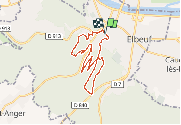
![](/images/other/stat-length.png)
![Tour Wandern Elbeuf - rando Elbeuf-sur-Seine](https://media.geolcdn.com/t/1900/400/9a69885d-b17d-49d7-920e-5a42b62a51b4.jpg&format=pjpeg&maxdim=2)
rando Elbeuf-sur-Seine "le mont Duve"
bipf
Benutzer
![Länge](/images/other/stat-length.png)
![Maximale Höhe](https://static1.geolcdn.com/siteimages/upload/files/1508320355ic_sort_altitude_max_24dp.png)
![Positive Höhendifferenz](https://static1.geolcdn.com/siteimages/upload/files/1508320355ic_sort_den_pos_24dp.png)
![Km-Effort](/images/other/stat-length.png)
![Min. Höhe](https://static1.geolcdn.com/siteimages/upload/files/1508320355ic_sort_altitude_min_24dp.png)
![Negative Höhendifferenz](https://static1.geolcdn.com/siteimages/upload/files/1508320355ic_sort_den_neg_24dp.png)
![Boucle](https://static1.geolcdn.com/siteimages/upload/files/16400158638029165_repeat_loop_refresh_sync_direction_icon.png)
![Wandern](https://static1.geolcdn.com/sitytour/trail-icons/101.png)
2h09
Schwierigkeit : Sehr leicht
![Scannen Sie diesen QR-Code, um die Tour in der SityTrail-Anwendung zu öffnen](https://capi.geolives.com/qq0zvz2zws4bq2lad0pu/sitytour/trails/2299537/qr.png?size=200)
Kostenlosegpshiking-Anwendung
Über SityTrail
Tour Wandern von 7,8 km verfügbar auf Normandie, Seine-Maritime, Elbeuf. Diese Tour wird von bipf vorgeschlagen.
Beschreibung
Belle ballade de moins de 8km au départ du parking public en face de pôle emploi rue Petou.
Vous emprunterez d'agréables sentiers en sous-bois tout au long de la ballade.
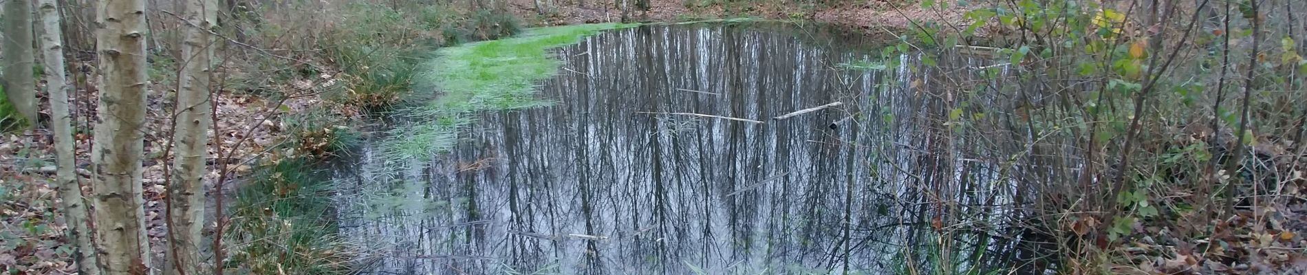
Vous pourrez vous arrêter au bord de cette jolie petite mare dans le parc "Laquerrière". Puis vous aurez une belle vue sur Caudebec et au-delà.
Vous redescendrez par la rue Sœur Marie-Alexis " attention : forte déclivité".
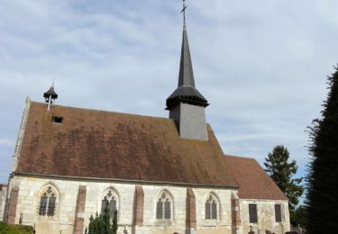
dans un des coudes, vous aurez la vue furtive sur les toits vernissés de l'église Saint-Etienne d'Elbeuf.
Vous emprunterez ensuite la sente des Echelettes ( attention : par temps de gel ou de pluie, il est préférable de continuer sur la rue sœur Marie-Alexis ).
Vous regagnerez ensuite le point de départ par la rue Petou.
Foto-Galerie
![Tour Wandern Elbeuf - rando Elbeuf-sur-Seine Tour Wandern Elbeuf - rando Elbeuf-sur-Seine](https://media.geolcdn.com/t/170/100/9a69885d-b17d-49d7-920e-5a42b62a51b4.jpg&format=jpg&maxdim=2)
![Tour Wandern Elbeuf - rando Elbeuf-sur-Seine Tour Wandern Elbeuf - rando Elbeuf-sur-Seine](https://media.geolcdn.com/t/170/100/769ab014-3bd2-4a47-800d-693c1f0bf323.jpg&format=jpg&maxdim=2)
Ort
Kommentare
Touren in der Umgebung
![Tour Wandern Caudebec-lès-Elbeuf - Caudebec-les- Elbeuf 12km - Photo](https://media.geolcdn.com/t/375/260/ff911e05-9d04-4aef-af60-0d3d13a09c7b.jpg&format=jpg&maxdim=2)
![Wandern Wandern](https://static1.geolcdn.com/sitytour/trail-icons/101.png)
Wandern
![](/images/other/stat-length.png)
![](https://static1.geolcdn.com/siteimages/upload/files/16400158638029165_repeat_loop_refresh_sync_direction_icon.png)
![Tour Wandern La Londe - La Londe 76- 13 km - Photo](https://media.geolcdn.com/t/375/260/23588b19-2689-475f-b2bd-10608cbf7253.jpg&format=jpg&maxdim=2)
![Wandern Wandern](https://static1.geolcdn.com/sitytour/trail-icons/101.png)
Wandern
![](/images/other/stat-length.png)
![](https://static1.geolcdn.com/siteimages/upload/files/16400158638029165_repeat_loop_refresh_sync_direction_icon.png)
![Tour Wandern Saint-Cyr-la-Campagne - Saint-Germain de Pasquier. 9 km - Photo](https://media.geolcdn.com/t/375/260/a7042a8e-39bd-47d3-8b07-a6773a8f9760.jpg&format=jpg&maxdim=2)
![Wandern Wandern](https://static1.geolcdn.com/sitytour/trail-icons/101.png)
Wandern
![](/images/other/stat-length.png)
![](https://static1.geolcdn.com/siteimages/upload/files/16400158638029165_repeat_loop_refresh_sync_direction_icon.png)
![Tour Wandern Caudebec-lès-Elbeuf - Caudebec les Elbeuf vers saint Cyr la campagne - Photo](https://media.geolcdn.com/t/375/260/ext.jpg?maxdim=2&url=https%3A%2F%2Fservices.sitytrail.com%2FGeolivesWS%2FDownloadMedia.ashx%3FTrailID%3D985245%26Media%3Dfix__20180531102544.jpg)
![Wandern Wandern](https://static1.geolcdn.com/sitytour/trail-icons/101.png)
Wandern
![](/images/other/stat-length.png)
![](https://static1.geolcdn.com/siteimages/upload/files/16400158638029165_repeat_loop_refresh_sync_direction_icon.png)
![Tour Wandern Saint-Germain-de-Pasquier - Circuit du Dué - St Germain de Pasquier - Photo](https://media.geolcdn.com/t/375/260/ext.jpg?maxdim=2&url=https%3A%2F%2Fservices.sitytrail.com%2FGeolivesWS%2FDownloadMedia.ashx%3FTrailID%3D111639%26Media%3D7883_6.jpg)
![Wandern Wandern](https://static1.geolcdn.com/sitytour/trail-icons/101.png)
Wandern
![](/images/other/stat-length.png)
![](https://static1.geolcdn.com/siteimages/upload/files/16400158638029165_repeat_loop_refresh_sync_direction_icon.png)
![Tour Mountainbike Caudebec-lès-Elbeuf - La Caudebécaise 2011 - 45 km - Caudebec-lès-Elbeuf - Photo](https://media.geolcdn.com/t/375/260/ext.jpg?maxdim=2&url=https%3A%2F%2Fservices.sitytrail.com%2FGeolivesWS%2FDownloadMedia.ashx%3FTrailID%3D106431%26Media%3D10925_1.jpg)
![Mountainbike Mountainbike](https://static1.geolcdn.com/sitytour/trail-icons/202.png)
Mountainbike
![](/images/other/stat-length.png)
![](https://static1.geolcdn.com/siteimages/upload/files/16400158638029165_repeat_loop_refresh_sync_direction_icon.png)
![Tour Wandern Cléon - 20200120-Cléon COOL - Photo](https://media.geolcdn.com/t/375/260/ext.jpg?maxdim=2&url=https%3A%2F%2Fstatic1.geolcdn.com%2Fsiteimages%2Fupload%2Ffiles%2F1553511878bg_sport_marche.png)
![Wandern Wandern](https://static1.geolcdn.com/sitytour/trail-icons/101.png)
Wandern
![](/images/other/stat-length.png)
![](https://static1.geolcdn.com/siteimages/upload/files/16400158638029165_repeat_loop_refresh_sync_direction_icon.png)
![Wandern Wandern](https://static1.geolcdn.com/sitytour/trail-icons/101.png)
Wandern
![](/images/other/stat-length.png)
![](https://static1.geolcdn.com/siteimages/upload/files/16400158638029165_repeat_loop_refresh_sync_direction_icon.png)
![Tour Wandern Saint-Pierre-lès-Elbeuf - orival les troglodyte - Photo](https://media.geolcdn.com/t/375/260/92f6efdc-352c-4a72-a8db-32871db4d1d7.jpg&format=jpg&maxdim=2)
![Wandern Wandern](https://static1.geolcdn.com/sitytour/trail-icons/101.png)
Wandern
![](/images/other/stat-length.png)
![](https://static1.geolcdn.com/siteimages/upload/files/16400158638029165_repeat_loop_refresh_sync_direction_icon.png)